
New tropical cyclone Lua moving slowly off the Pilbara coast, Australia
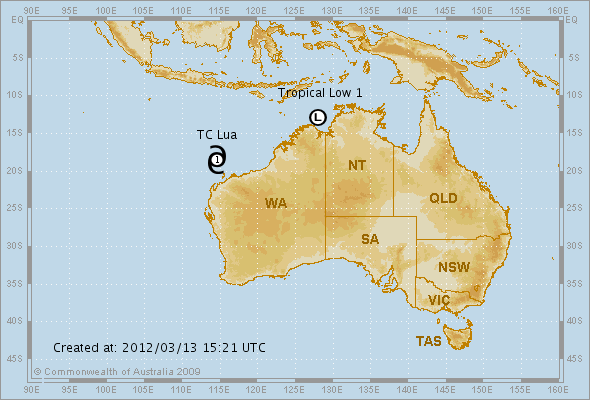
Image credit: bom.gov.au
A new tropical cyclone has formed off the Pilbara coast, Australia. On March 13th, 2012 Tropical Cyclone Lua (Category 1) was located at 8 pm WST near 18.5S 114.6E, that is 340 km northwest of Karratha and 385 km north of Exmouth and slow moving. TC Lua lies well north of the west Pilbara coast and is expected to slowly intensify and drift northwards for the next 24 hours. The system is then expected to continue intensifying and move southeast towards the east Pilbara coast later in the week.
Second active system – Tropical Low – A Cyclone WARNING continues for coastal and island communities from Cape Hotham to Kalumburu, including Darwin and the Tiwi Islands, and inland to Batchelor, Adelaide River and Daly River. At 9:30 pm CST <8:00 pm wst > today a Tropical Low was estimated to be 315 kilometres west of Darwin and 215 kilometres northwest of Port Keats and moving south at 7 kilometres per hour.
The tropical low appears to be taking a slow southerly track but is expected to curve southeast towards the western Top End coast early Wednesday. The low is expected to develop into a tropical cyclone on Wednesday morning and is likely to cross the southwest coast of the Top End on Wednesday night.

Video forecast by 28storms.com
Tropical Cyclone Lua – Tracking Map
Tropical Low – Tracking Map
More information and latest updates can be found at www.bom.gov.au
I'm a dedicated researcher, journalist, and editor at The Watchers. With over 20 years of experience in the media industry, I specialize in hard science news, focusing on extreme weather, seismic and volcanic activity, space weather, and astronomy, including near-Earth objects and planetary defense strategies. You can reach me at teo /at/ watchers.news.
Commenting rules and guidelines
We value the thoughts and opinions of our readers and welcome healthy discussions on our website. In order to maintain a respectful and positive community, we ask that all commenters follow these rules.