
Tropical cyclone Lua expected to intensify into a severe tropical cyclone during Thursday
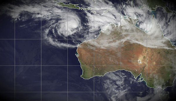
Image credit: TW
According to Australian Bureau of Meteorology, as of 2:00 am WST Tropical Cyclone Lua (Category 2) was estimated to be 700 kilometres northwest of Karratha, 790 kilometres northwest of Port Hedland and it is moving north at speed of 4 kilometres per hour. Lua is expected to intensify into a severe tropical cyclone during Thursday and remain intense as it approaches the coast. A Cyclone Watch is current for coastal areas from Cape Leveque to Mardie, as well as adjacent inland parts.
Tropical cyclone Lua formed off the northern coast of Western Australia. On March 13, it was a minimum tropical storm with maximum sustained winds near 35 knots (~40 mph/~65 kph) and was located about 240 miles west-northwest of Port Hedland, Australia. It was barely moving at 2 knots (~2 mph/~4 kph) to the west-northwest, but is expected to turn to the east-southeast. Forecasters at the Joint Typhoon Warning Center expect Lua to meander for a day or two before intensifying and making landfall in the Pilbara region sometime on March 16.

According to JTWC Tropical Cyclone Lua (TC 17S) is located 385 nm north of Learmonth and is moving east-southeastward at 2 knots over the past six hours. The initial intensity is assessed at 60 knots and is based on Dvorak estimates. Upper level analysis indicates TC Lua is 5 degrees equatorward of a ridge axis with a point source to northeast. The system is currently completing a turn to the southeast and is forecast to track southeastward under the steering influence of a deep layer ridge north of the Australian continent. Maximum significant wave height is 7 meters (23 feet).
Forecast Track Map (WA)
Tropical Cyclone Advice
High Seas Warning
Tropical Cyclone Technical Bulletin

Lua’s movement has slowed over the last 6 hours, and it is likely to turn back towards the Pilbara coast during Thursday. According to Australian Bureau of Meteorology, Lua is expected to intensify into a severe tropical cyclone during Thursday and remain intense as it approaches the coast. Gales are not expected in coastal areas during Thursday. Gales are expected to develop during Friday or early Saturday as the cyclone approaches the coast. Destructive to very destructive winds are expected to develop in coastal areas near the centre of the cyclone during Saturday. Heavy rainfall is expected in coastal areas of the east Pilbara and west Kimberley during Thursday and Friday.
Details of Tropical Cyclone Lua at 2:00 am WST: .Centre located near...... 15.6 degrees South 113.0 degrees East .Location accuracy........ within 55 kilometres .Recent movement.......... towards the north at 4 kilometres per hour .Wind gusts near centre... 140 kilometres per hour and INTENSIFYING .Severity category........ 2 .Central pressure......... 975 hectoPascals
FESA-State Emergency Service advises that there are no community alerts at present. Communities between Mardie and Cape Leveque should listen for the next advice.

New tropical low is forming
At 3:30am a TROPICAL LOW 997hPa was located over land near 15.8S 131.5E about 85 km northeast of Victoria River Downs and 175 km south-southwest of Katherine, moving east-southeast at 27 kilometres per hour. Strong and squally northwest monsoonal winds are affecting island and coastal areas north of the low.
Damaging wind gusts up to 100 km/h are possible with squally monsoonal showers in the Darwin-Daly District, including the Tiwi Islands during today. Heavy monsoonal rain currently falling over the Darwin-Daly District, including the Tiwi Islands, and northern Victoria River District may lead to flash flooding.
Severe Weather Warning
Coastal Waters Warning issued by Darwin

Commenting rules and guidelines
We value the thoughts and opinions of our readers and welcome healthy discussions on our website. In order to maintain a respectful and positive community, we ask that all commenters follow these rules.