
Fabulous displays of northern lights after M8.7 solar flare

Image credit: TW
The anticipated geomagnetic storm caused by Monday’s M8.7 solar flare and Tuesday’s coronal mass ejection (CME) impact is over. The aurora watch has been cancelled today for all but the highest latitudes around the Arctic Circle but a dazzling display of auroras did lit up the far northern skies in a supercharged light show.
Even experienced stargazers were stunned by the intensity of the aurora borealis that swept across the night sky in northern Scandinavia after the biggest solar flare in six years. "It has been absolutely incredible," British astronomer John Mason cried from the deck of the MS Midnatsol, a cruise ship plying the fjord-fringed coast of northern Norway.

There are reports of spectacular displays of the aurora seen at high latitudes in Europe. Reporting for Associated Press, Karl Ritter and Seth Borenstein say that “experienced stargazers were stunned by the intensity of the aurora borealis that swept across the night sky in northern Scandinavia” during the night of January 24, 2012.
"It was the biggest northern lights I've seen in the five-six years that I've worked here," said Andreas Hermansson, a tour guide at the Ice Hotel in the Swedish town of Jukkasjarvi, above the Arctic Circle.


Coronal aurora over Fairbanks, Alaska (January 22, 2012)
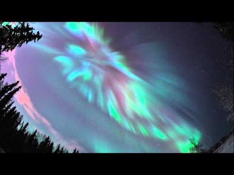
- View SpaceWeather's January 2012 aurora gallery here.
Featured photo credit: Jaromir Stanczyk

Teo Blašković founded The Watchers in 2011 and edited it until 2026, covering seismic and volcanic activity, extreme weather, space weather and near-Earth objects. Articles on this page are his archive.
Earlier reporting
Nothing on Watchers was published in the last 24 hours. These are older articles.
- On October 22, 2017, a single flash of lightning stretched 515 miles from eastern Texas to near Kansas City, a distance that takes eight hours to drive, and nobody realized how far it had gone until scientists went back through the satellite data years later Epicenter
- CPC posts a slight risk of heavy rain from the Gulf Coast to the Northeast urban corridor November 25-29, and a moderate risk of West Coast wind and Sierra snow on November 25
- Florida's east coast faces a moderate flash flood risk Wednesday through Friday, with 4 to 8 inches of rain forecast and the St. Johns River near Cocoa already in major flood at 17.13 feet
- Cyclone Akvan to make landfall between Nellore and Visakhapatnam around noon on November 20, IMD forecasts 120-130 km/h winds gusting to 145
