
Auroral Tempest – Time-lapse video by InFocus Imagery
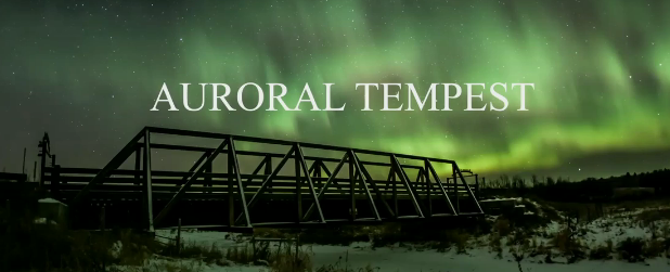
Image credit: TW
This time-lapse was captured on the morning of November 11, 2013. It is suspected that two CMEs (Coronal Mass Ejections) on November 8th and 10th from two separate X-class solar flares combined to form one cloud of plasma. The interaction of this energy with Earth's magnetosphere created the following visual feast.
Conditions were a chilly -22 degrees C with no wind. It was a very beautiful night above the snow covered fields on the Alberta prairie.
Featured image and video courtesy of InFocusImagery.com

Teo Blašković founded The Watchers in 2011 and edited it until 2026, covering seismic and volcanic activity, extreme weather, space weather and near-Earth objects. Articles on this page are his archive.
Earlier reporting
Nothing on Watchers was published in the last 24 hours. These are older articles.
- On October 22, 2017, a single flash of lightning stretched 515 miles from eastern Texas to near Kansas City, a distance that takes eight hours to drive, and nobody realized how far it had gone until scientists went back through the satellite data years later Epicenter
- CPC posts a slight risk of heavy rain from the Gulf Coast to the Northeast urban corridor November 25-29, and a moderate risk of West Coast wind and Sierra snow on November 25
- Florida's east coast faces a moderate flash flood risk Wednesday through Friday, with 4 to 8 inches of rain forecast and the St. Johns River near Cocoa already in major flood at 17.13 feet
- Cyclone Akvan to make landfall between Nellore and Visakhapatnam around noon on November 20, IMD forecasts 120-130 km/h winds gusting to 145

Commenting rules and guidelines
We value the thoughts and opinions of our readers and welcome healthy discussions on our website. In order to maintain a respectful and positive community, we ask that all commenters follow these rules.