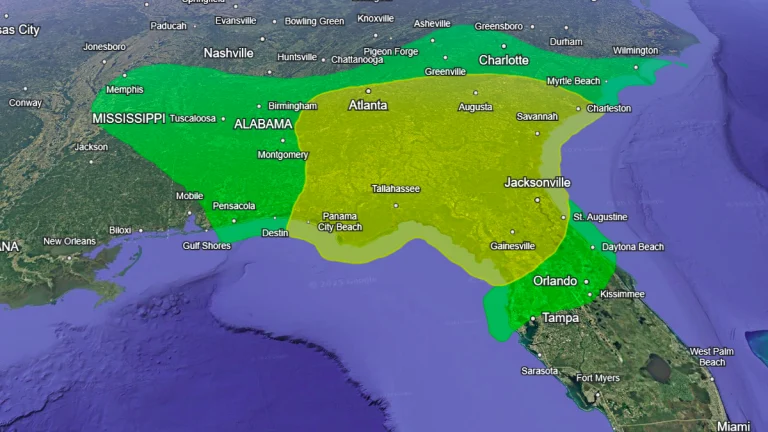
• Damaging tornado strikes St. Johns County, Florida

    A tornado touched down in St. Johns County, Florida, on May 29, 2025, near SR9B and St. Johns Parkway, causing significant damage to trees, power lines, and structures. The National Weather Service (NWS) is conducting a survey to assess the tornado’s strength and path, with no injuries reported.

  • Saharan dust plume to reach Florida by weekend, Texas by next week

    A plume of Saharan dust stretching from the coast of Africa to the northwestern Caribbean and into the Gulf of Mexico is forecast to reach Florida by Saturday, May 31, 2025. Southern and central parts of the state are expected to experience hazy skies and reduced air quality over the weekend. A denser plume could arrive by mid-next week, with the dust reaching Texas by Tuesday, June 3.

  • Downburst damages multiple aircraft at North Perry Airport, Florida

    A severe thunderstorm produced a damaging downburst in Pembroke Pines, Florida, on Friday, May 23, 2025, severely damaging multiple aircraft at North Perry Airport and prompting an emergency airport closure. Straight-line winds also caused widespread damage across Broward County, with hail reported along the Treasure Coast.

  • 126-year-old rain record broken in Charleston as heavy rain spreads across Southeast

    Charleston, South Carolina, set a new daily rainfall record on Sunday, May 11, 2025, after a moisture-laden storm system brought prolonged periods of heavy rain to the region. The event marked the highest recorded precipitation for that date at Charleston International Airport, with widespread impacts extending across the Southeast and mid-Atlantic. Flash flood threats are expected to persist through Wednesday, May 14, according to the Weather Prediction Center (WPC).

  • Red Flag Warnings issued across east Florida

    A Red Flag Warning has been issued for nearly all of eastern Florida, from Daytona Beach to Miami, on Thursday, March 20, 2025, as wildfires burned over 5 655 (14 000 acres) across the state.