
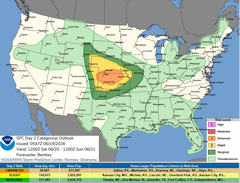
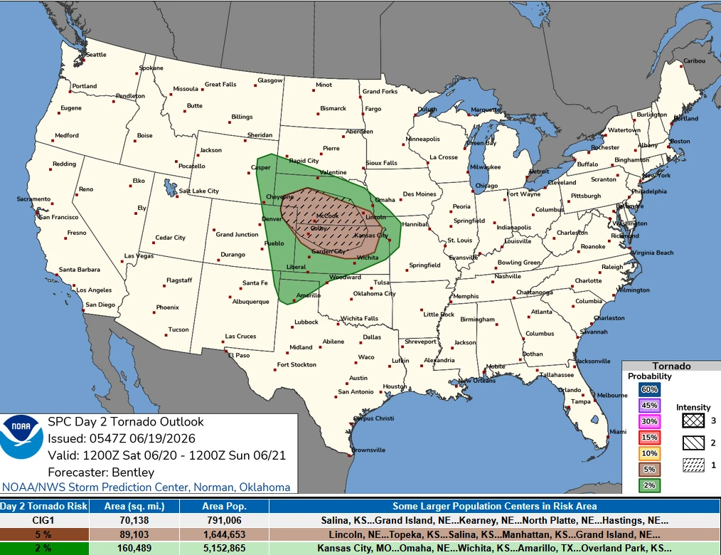
SPC issues Enhanced Risk for severe thunderstorms across portions of the Central Plains
The Storm Prediction Center (SPC) has placed portions of the Central Plains including parts of Kansas and Nebraska under an Enhanced Risk of severe thunderstorms for Saturday, June 20, 2026. Large to very large hail, damaging winds exceeding 121 km/h (75 mph), and tornadoes possible from afternoon into evening hours.
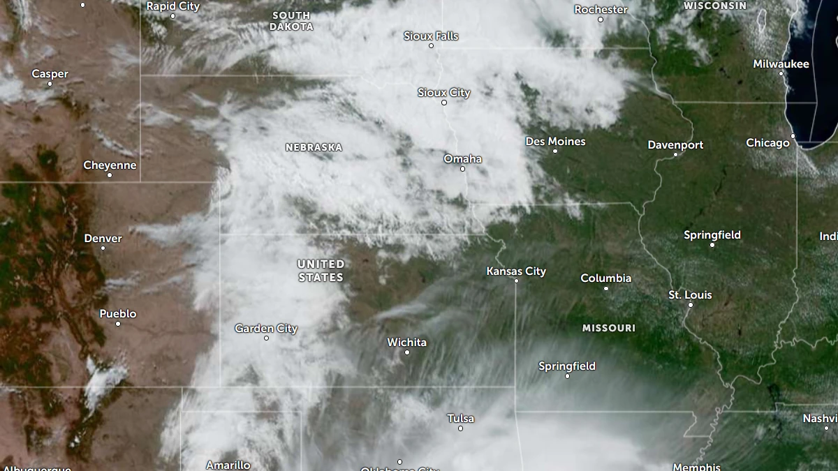
Satellite image of central USA at 16:50 UTC on June 19, 2026. Credit: NOAA/GOES-19, Zoom Earth, The Watchers
The Storm Prediction Center (SPC) has placed portions of the Central Plains under an Enhanced Risk of severe thunderstorms for Saturday, June 20, with large to very large hail, damaging winds exceeding 121 km/h (75 mph), and tornadoes possible from afternoon into evening hours.
Severe thunderstorms are forecast across portions of the Central Plains vicinity from Saturday afternoon into Saturday evening. Large to very large hail, severe winds with some gusts exceeding 121 km/h (75 mph), and tornadoes will be the primary hazards.
The forecast is tied to an evolving synoptic pattern across the western and central United States. A mid-level ridge is forecast to de-amplify as it emerges from the Rockies into the central Plains while stronger mid-level flow develops across the Rockies.
At the surface, strong lee cyclogenesis is expected across eastern Colorado, with a frontal zone extending eastward from a surface low near southern Nebraska and a dryline extending southward into the southern Plains.
As the lee cyclone deepens, low-level flow is forecast to strengthen across the Plains, transporting moisture northward and increasing instability across Kansas, northeast Colorado and southwest Nebraska.
The combination of richer moisture, steep lapse rates and strong wind shear is expected to create an environment favorable for organized severe thunderstorms.
By mid-afternoon, storms are expected to develop within the upslope flow regime across eastern Wyoming, southwest South Dakota and the Nebraska Panhandle.
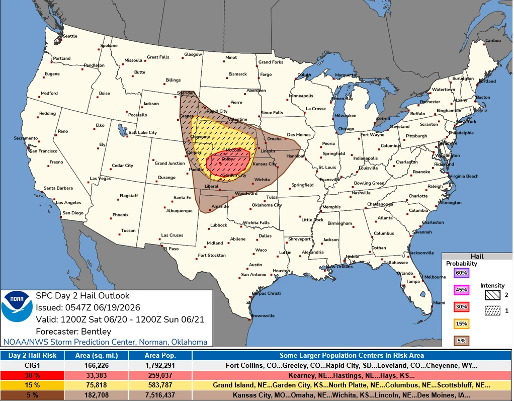
Forecast soundings cited by the SPC show cool temperatures aloft, steep lapse rates and strong shear, supporting supercells capable of producing large to very large hail.
Additional thunderstorm development is forecast later in the afternoon along the uncapped dryline across eastern Colorado and western Kansas and along the frontal zone across central and southern Nebraska.
Moderate mid-level flow within the warm sector is expected to support a supercell storm mode. These initial storms will pose a threat for large to very large hail, while tornado potential will increase, particularly near the frontal boundary and as the low-level jet strengthens during the evening.
The SPC expects these supercells to congeal into one or more mesoscale convective systems (MCSs) during the evening and track southeastward into central and eastern Kansas.
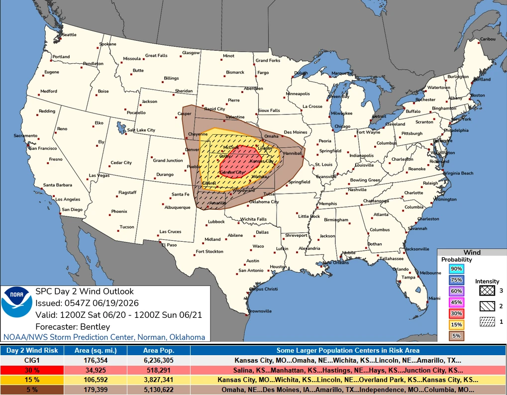
As storms evolve, the wind threat is expected to increase, with some gusts exceeding 121 km/h (75 mph). The outlook also notes the potential for a quasi-linear convective system (QLCS) and embedded supercell tornado threat.
References:
1 Day 2 convective Outlook – SPC – June 19, 2026

I am an Assistant Editor and Severe Weather & Science Journalist at The Watchers, specializing in real-time severe weather coverage, geophysical event reporting, and research-driven scientific analysis. You can reach me at rishav(at)watchers(.)news.
Commenting rules and guidelines
We value the thoughts and opinions of our readers and welcome healthy discussions on our website. In order to maintain a respectful and positive community, we ask that all commenters follow these rules.