
Critical fire-weather conditions forecast across eastern New Mexico and western Texas
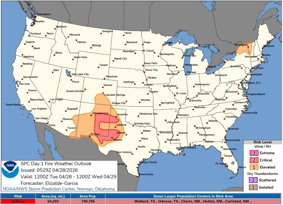
Critical fire-weather conditions are forecast across parts of eastern New Mexico and western Texas on Tuesday, April 28, 2026, as west to southwest winds of 25–30 km/h (15–20 mph) combine with relative humidity of 10–20% over dry fuels. The Storm Prediction Center outlined a Critical Fire Weather Area covering approximately 140 380 km² (54 200 mi²) and 740 760 people, with the strongest overlap of wind and humidity reductions forecast from east-central and southeastern New Mexico into adjacent Texas.

Critical Fire Weather map for 24 hours ending 14:00 EDT on April 29, 2026. Credit: NWS/SPC
The Storm Prediction Center (SPC) outlined the Critical Fire Weather Area for portions of eastern New Mexico and western Texas on April 28, with Midland, Odessa, Clovis, Hobbs, and Carlsbad among the larger population centers inside the risk area.
SPC expects widespread west to southwest winds of 25–30 km/h (15–20 mph) across the Southern Plains, with relative humidity falling to 10–20% over dry fuels. Stronger wind corridors of 30–40 km/h (20–25 mph), combined with humidity near 10%, are forecast across east-central and southeastern New Mexico into adjacent parts of Texas within the core Critical fire-weather corridor.
A mid- and upper-level shortwave trough moving across the Southwest and High Plains will support strong westerly flow aloft, downslope warming, and boundary-layer mixing, maintaining dry and windy surface conditions across the region. SPC placed the strongest fire-spread potential where wind, dry air, and receptive fuels overlap during the afternoon.
NWS Albuquerque said Critical fire-weather conditions will focus mostly across eastern New Mexico on Tuesday, with Elevated conditions elsewhere, and advised avoiding activities that produce sparks. The office issued a Red Flag Warning and said dry and breezy conditions would continue through mid-week before precipitation enters New Mexico later in the week.
NWS Midland/Odessa said Critical fire-weather conditions are expected across southeast New Mexico and portions of West Texas from morning through evening on April 28. The office issued a Red Flag Warning and urged residents to avoid outdoor burning and activities that cause sparks or open flame.
Farther northeast, SPC forecast an Elevated fire-weather threat across Upstate New York and western Vermont. Southerly winds of 16–25 km/h (10–15 mph), terrain-enhanced corridors near 30 km/h (20 mph), and relative humidity of 25–35%, locally near 20%, are forecast to align with dry fuels.
NWS Burlington issued a Fire Weather Watch for northern New York and western Vermont on April 28, saying south winds of 15–25 km/h (10–15 mph), gusts up to 50 km/h (30 mph), and relative humidity as low as 20–25%, would make fire containment difficult if fires start.
The National Interagency Fire Center’s April outlook placed much of the central and southern High Plains into most of New Mexico under above-normal significant wildland fire potential for April.
References:
1 Day 1 Fire Weather Outlook – NWS/SPC – April 28, 2026
I'm a dedicated researcher, journalist, and editor at The Watchers. With over 20 years of experience in the media industry, I specialize in hard science news, focusing on extreme weather, seismic and volcanic activity, space weather, and astronomy, including near-Earth objects and planetary defense strategies. You can reach me at teo /at/ watchers.news.
Commenting rules and guidelines
We value the thoughts and opinions of our readers and welcome healthy discussions on our website. In order to maintain a respectful and positive community, we ask that all commenters follow these rules.