
Lava reaches lower southern slope of Etna, 2 km (1.2 miles) from Altamontana trail
New lava flow from Mount Etna’s summit is advancing along the southern flank, reaching an elevation of about 2 270 m (7 450 feet). The most advanced front is now located about 2 km (1.24 miles) from the Altamontana trail, a major access route used for monitoring and hiking, following effusion that began on August 9, 2025.
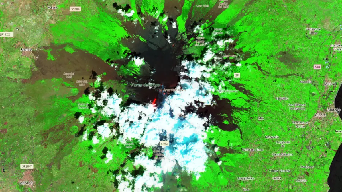
IR satellite image of Etna volcano on August 20, 2025. Credit: Copernicus EU/Sentinel-2, The Watchers
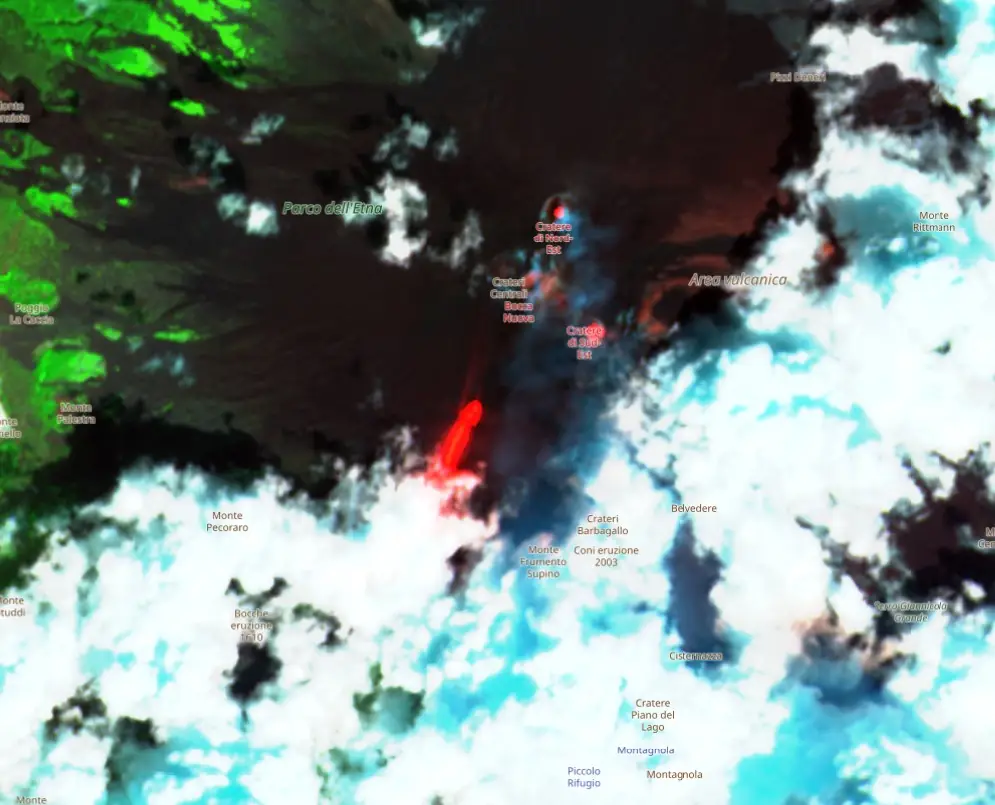
An effusive fissure opened late on August 9, 2025, between Bocca Nuova and the South-East Crater of Mount Etna, at an elevation of approximately 3 000 to 3 100 m (9 840–10 170 feet) above sea level (a.s.l.).
The fissure produced a lava flow that traveled about 600 m (1 970 feet) to the south before the effusion ceased the following day. Subsequent activity re-established and expanded lava field that remains active to date.
According to the National Institute of Geophysics and Volcanology’s Etna Observatory (INGV-OE), an active vent at 2 980 m (9 777 feet) a.s.l. continues to feed lava through a complex system including a lava tunnel and several ephemeral vents.
VIDEO UPDATE
— Etna Walk (@etnawalk) August 19, 2025
Etna Eruption – 19/8/2025
© Giuseppe Distefano / Marco Restivo#Etna #EtnaWalk #EtnaEruption #volcano @INGV_press @NatGeoMagITA @NatGeo @DJIGlobal @MilletMountain pic.twitter.com/itghnljlUK
The flow has divided into two main arms migrating southwest, with the most advanced front currently at about 2 270 m (7 450 feet) elevation, near the Cave of the Arches, approximately 2 km (1.2 miles) from the Altamontana track.
The Altamontana track (Pista Altomontana) is a well-established trail that encircles Mount Etna at elevations between approximately 1 700 and 2 000 m (5 550–6 550 feet) a.s.l. It serves both as a strategic access route for volcanological monitoring teams and as a popular hiking path for visitors.
Its proximity to the advancing lava front provides a geographic reference point in INGV assessments and may influence decisions regarding access restrictions and safety measures if the flow continues to approach inhabited or frequented areas.
VIDEO UPDATE
— Etna Walk (@etnawalk) August 18, 2025
Etna Eruption – 17/8/2025
© Giuseppe Distefano#Etna #EtnaWalk #EtnaEruption #volcano pic.twitter.com/ftKtMSSRTB
The INGV reports Strombolian explosive activity at the South-East Crater continues with variable intensity. Reddish ash emissions have also been intermittently observed from the Bocca Nuova Crater.
As of 21:00 local time (19:00 UTC) on August 18, the average amplitude of volcanic tremor rose to high levels, with weak oscillations. The tremor’s source is located in proximity to the South-East Crater, at depths between 2 900 and 3 000 m (9 500–9 840 feet) a.s.l. Infrasonic activity remains moderate, with events localized at the South-East Crater and characterized by medium-width signals.
No significant changes have been detected by INGV’s GNSS and clinometric deformation monitoring networks. However, the DRUV tilt station has registered a gradual inversion of its typical trend, which may suggest evolving magmatic conditions.
The INGV’s weekly bulletin, released on August 19, covering the week of August 11–17, confirmed persistent effusive activity from a fracture vent at the base of Bocca Nuova, along with ongoing Strombolian activity at the South-East Crater. Degassing was also noted at Bocca Nuova, Voragine, and the Northeast Crater.
Throughout that week, volcanic tremor amplitude remained mostly at medium levels. No fracturing seismic events with magnitude ≥2.0 were recorded. Infrasonic activity remained moderate, and ground deformation signals from GNSS and tilt networks indicated no significant variations.
Mount Etna is Europe’s most active volcano and the highest in Italy, rising above the city of Catania on the island of Sicily. Its volcanic history extends back to at least 1500 BCE.
The volcano features both summit eruptions and less frequent, high-effusion flank eruptions that produce extensive lava flows. Its most prominent geological structure is the Valle del Bove, a 5 × 10 km (3.1 × 6.2 miles) caldera open to the east, and much of its surface is covered by historical basaltic lava flows.
I'm a dedicated researcher, journalist, and editor at The Watchers. With over 20 years of experience in the media industry, I specialize in hard science news, focusing on extreme weather, seismic and volcanic activity, space weather, and astronomy, including near-Earth objects and planetary defense strategies. You can reach me at teo /at/ watchers.news.
Commenting rules and guidelines
We value the thoughts and opinions of our readers and welcome healthy discussions on our website. In order to maintain a respectful and positive community, we ask that all commenters follow these rules.