
Multiple rounds of storms forecast to impact southern Plains through Friday
A moist low-level jet interacting with outflow boundaries will drive widespread showers and thunderstorms across the southern Plains through June 13, 2025. The heaviest rainfall is expected in east-central Texas, where 50–100 mm (2–4 inches) is forecast, with isolated areas potentially receiving up to 150 mm (6 inches).
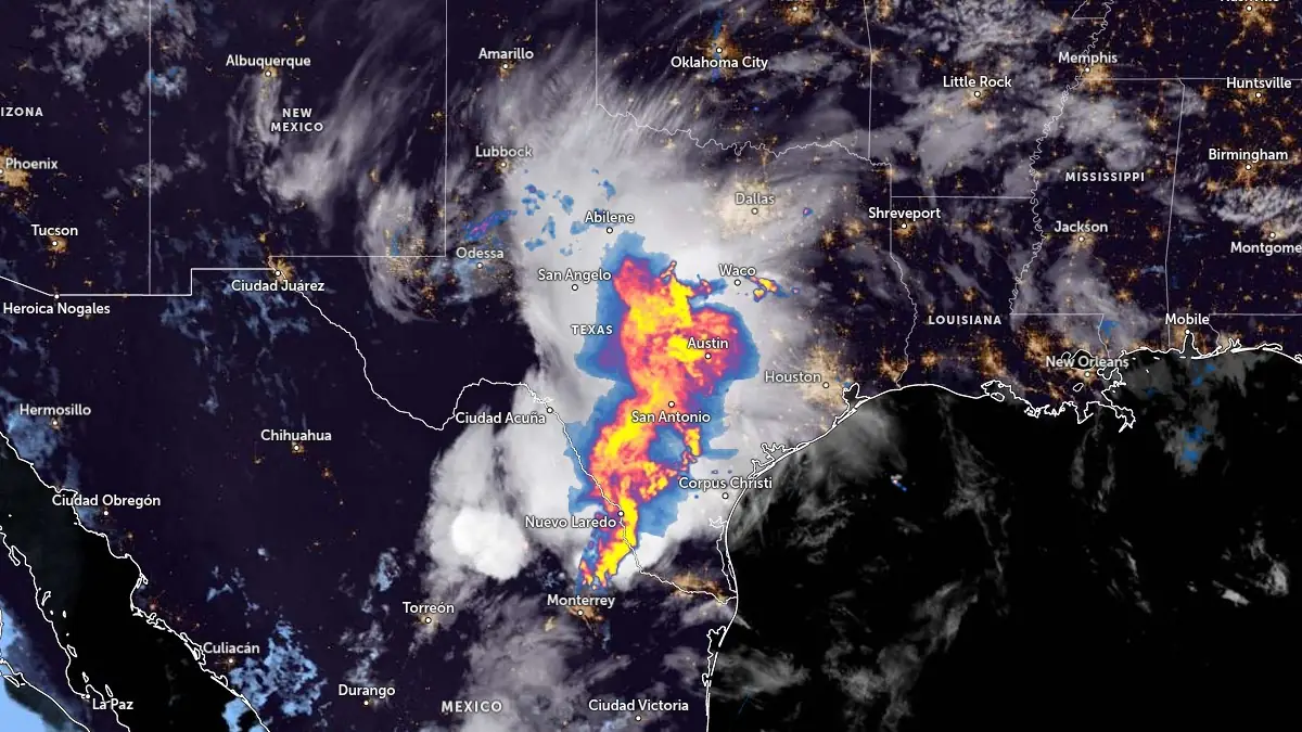
Image credit: NOAA/GOES-East, RAMMB/CIRA, The Watchers. Acquired at 07:50 UTC on June 11, 2025
Widespread showers and thunderstorms are forecast to persist across central and eastern Texas, the ArkLaTex region, and western Louisiana through Friday morning, June 13.
According to the U.S. Weather Prediction Center (WPC), a Moderate Risk (level 3 of 4) for excessive rainfall will be valid for east-central Texas on Wednesday, June 11. Forecast models suggest widespread 50–100 mm (2–4 inches) of rain, with isolated totals reaching up to 150 mm (6 inches), particularly where multiple rounds of convection overlap.
These repeated rounds of storms are being driven by a persistent moist low-level jet intersecting with outflow boundaries. Enhanced low-level moisture convergence is expected to support the development of additional convective cells through the midweek period.


The Storm Prediction Center (SPC) has issued a Slight Risk (level 2 of 5) for severe weather across southeastern Texas for Wednesday. The severe threat is being fueled by high convective available potential energy (CAPE), which could support strong wind gusts and large hail, particularly in the evening hours.
The National Weather Service (NWS) has issued flood advisories for multiple counties across south-central Texas, including the San Antonio metro area, where 40–75 mm (1.5–3 inches) of rain is expected. Flash flooding is possible in urban and low-lying areas, especially where soils are already saturated from earlier rainfall.
A separate area of concern is developing over the Upper Midwest, particularly southern Minnesota. The WPC has placed this region under a slight risk (level 2 of 4) for excessive rainfall valid from Thursday evening into Friday morning, June 13. Forecast totals of 25–50 mm (1–2 inches) are expected, with locally higher amounts possible due to frontal boundary interaction with a mid-level shortwave trough.
I'm a dedicated researcher, journalist, and editor at The Watchers. With over 20 years of experience in the media industry, I specialize in hard science news, focusing on extreme weather, seismic and volcanic activity, space weather, and astronomy, including near-Earth objects and planetary defense strategies. You can reach me at teo /at/ watchers.news.
Commenting rules and guidelines
We value the thoughts and opinions of our readers and welcome healthy discussions on our website. In order to maintain a respectful and positive community, we ask that all commenters follow these rules.