
Record rainfall impacts New Orleans as severe storms move through Louisiana
Record rains drenched New Orleans on Wednesday, May 7, 2025, as severe storms brought flash floods and strong gusts to parts of Louisiana, causing widespread damage.
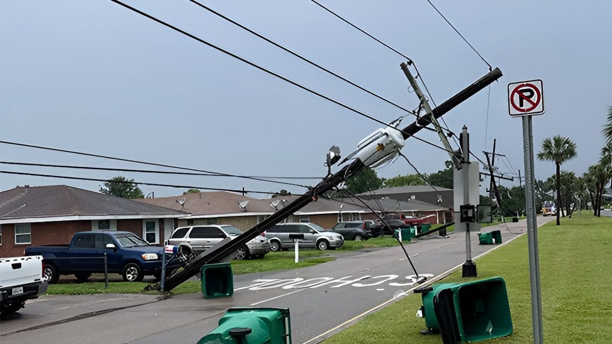
Storm damage in Jefferson Parish, Louisiana on Wednesday, May 7, 2025. Image credit: Scott Walker - Jefferson Parish Councilman At-Large
New Orleans set a new daily rain record for May 7 after recording 41.7 mm (1.64 inches) of rain and breaking the previous record of 33.8 mm (1.33 inches) set in 1976. Meanwhile, parts of the state reported 150 to 200 mm (6 to 8 inches) of rain as the storms moved in from Texas, triggering flash floods.
A Flash Flood Watch remains in effect across the southern and eastern portions of the state, including New Orleans, through 19:00 local time (LT) on Thursday, May 8.
The storms led to widespread damage across the state as strong gusts downed trees and power lines, triggering power outages and prompting school closures. More than 5 000 customers were without power by Wednesday afternoon, with over 3 000 remaining without power by early hours of Thursday.
New Orleans woke up drenched this morning as torrential rain hammered the city this morning. A Level 3 out of 4 flood risk is still in play today for New Orleans. #LAwx pic.twitter.com/JjV2QRAZ4n
— WeatherNation (@WeatherNation) May 7, 2025
Crazy video of how intense the wind gusts were with the West Bank storm. Trevor Buchanan #lawx pic.twitter.com/edYlOAjfEJ
— Zack Fradella (@ZackFradellaWx) May 7, 2025
New Orleans’ Lakefront Airport recorded a gust of 93 km/h (58 mph) on Wednesday. Councilman Scott Walker reported storm damage in Jefferson Parish, near New Orleans, stating that a possible tornado tore across the region.
Visuals showed downed trees and power lines, along with damage to fences and homes, with dustbins spread across roads after being flung around by strong gusts across the area.
Meanwhile, the Plaquemines Parish Fire Department reported that multiple trees were downed in the Belle Chasse area, and they were coordinating with the local volunteer fire department to clear out the roads.
Storm damage was also reported in Terrytown, with a fallen tree on the Hamilton road creating dangerous driving conditions for drivers trying to go around it after the storm.
The weather is expected to remain unsettled for much of the region through the weekend, with the National Weather Service (NWS) forecasting moderate rainfall.
The storms were part of a larger severe weather event that was triggered by the omega block weather pattern over the U.S.
The severe weather conditions had moved in from Texas on Wednesday morning, where it claimed the life of a 10-year-old girl and caused widespread damage.
Read more:

I am an Assistant Editor and Severe Weather & Science Journalist at The Watchers, specializing in real-time severe weather coverage, geophysical event reporting, and research-driven scientific analysis. You can reach me at rishav(at)watchers(.)news.
Commenting rules and guidelines
We value the thoughts and opinions of our readers and welcome healthy discussions on our website. In order to maintain a respectful and positive community, we ask that all commenters follow these rules.