
Long-duration atmospheric river brings heavy rain and snow across California
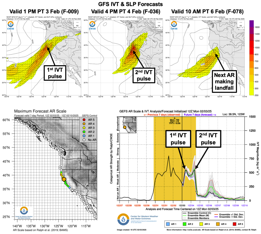
A long-duration atmospheric river (AR) continues to impact Northern California, bringing heavy precipitation, with two additional moisture pulses expected before it dissipates on Wednesday, February 5, 2025.
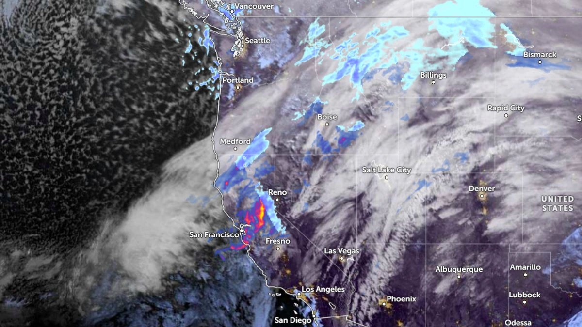
Satellite image of atmospheric river impacting California at 12:40 UTC on February 4, 2025. Credit: NOAA, Goes-East, Zoom Earth, The Watchers
- The ongoing atmospheric river (AR) has persisted for over 96 hours in some areas of California, with two additional pulses of moisture expected before it dissipates on February 5.
- Davis Creek recorded 45.7 cm (18 inches) of snow, while Hillcrest saw the highest rainfall at 328 mm (12.92 inches) between January 31 and February 3. Other states, including Montana, Idaho, and Oregon, also reported significant snowfall and rainfall.
- A weaker AR is expected to make landfall over California on February 6, bringing further precipitation and keeping the risk of excessive rainfall in place through early February 7.
- Major-to-extreme winter storm impacts are expected in the higher terrain of the Sierra Nevada due to heavy snow and high winds.
Atmospheric river impacting California since Friday, January 31 will gradually settle southward through the middle of the week as multiple waves of low pressure traverse the front and bring strong Pacific moisture transport into the coastal ranges, portions of the Central Valley, and the foothills of the Sierra Nevada.
This will result in more heavy rain for the region with concerns for flooding which will also include the Bay Area.
An additional 50 to 100 mm (2 to 4 inches) of rain is expected for the coastal ranges, with 75 to 150+ mm (3 to 6+ inches) for the Sierra Nevada foothills. The Weather Prediction Center has maintained a Slight Risk (level 2 of 4) of excessive rainfall across the region to account for this. Meanwhile, for the highest elevations of the central and northern Sierra Nevada, as much as 30 to 90 cm (1 to 3 feet) of new snowfall is expected.
By the time this AR dissipates, some locations in Northern California will have experienced more than 96 hours or 4 days of continuous AR conditions.
A weaker AR is forecast to make landfall over California on Thursday, February 6, bringing additional precipitation across the region.
The current AR has already brought significant precipitation in the form of both snow and ice across the region, with winter weather advisories remaining in effect for much of Northern California.
Davis Creek recorded the heaviest snowfall in California, with 45.7 cm (18 inches) of accumulated snow by 18:00 PST on Monday, February 2 (02:00 UTC on Tuesday, February 3). Meanwhile, Hillcrest recorded the highest rainfall, reporting 328 mm (12.92 inches) between January 31 and February 3, followed by British Creek Ranger Station with 325.4 mm (12.81 inches) during the same period.
Several other states also reported significant snowfall. Cooke City, Montana, recorded 81.3 cm (32 inches) of snow by 18:00 PST on Monday. Meanwhile, Hailey, Idaho, reported 71.1 cm (28 inches), followed by Galena with 68.6 cm (27 inches) during this period.
Oregon recorded both snow and rain, with O’Brien and Brookings receiving approximately 76.2 mm (3 inches) of rainfall, while areas such as Altamont accumulated 22.9 cm (9 inches) of snow during this period.
The NWS Weather Prediction Center (WPC) forecasts an additional 152 – 305 mm (6 – 12 inches) of precipitation in the Northern Sierra Nevada and 76 – 203 mm (3 – 8 inches) in the Northern/Central California Coast Ranges and Central/Southern Sierra Nevada over the next seven days.
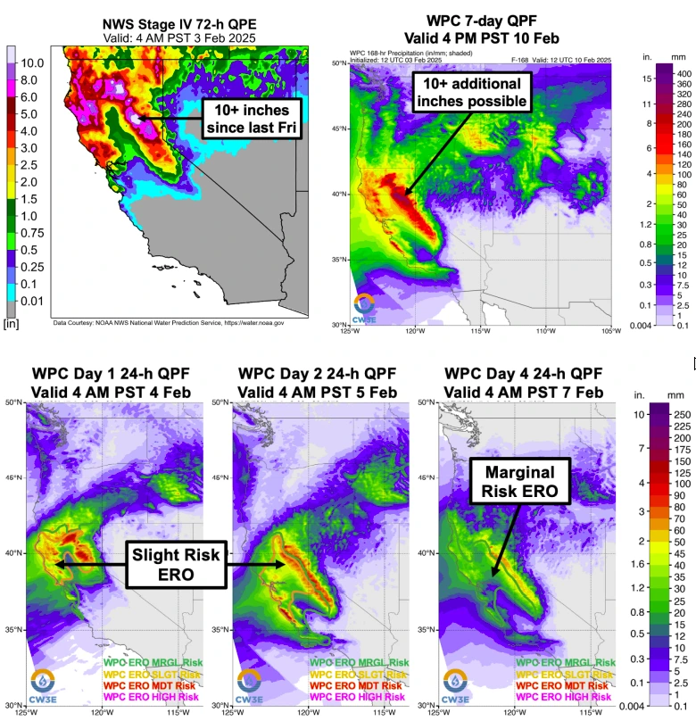
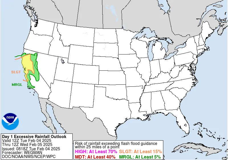
The WPC has issued a slight risk of excessive rainfall for the Northern/Central California Coast Ranges, Bay Area, Sacramento Valley, northern San Joaquin Valley, and Northern/Central Sierra Nevada foothills through early Wednesday, indicating a less than 15% probability of excessive rainfall.
A marginal risk outlook, indicating a less than 5% probability of excessive rainfall, has been issued for northeastern California, the southern San Joaquin Valley, the Southern Sierra Nevada foothills, and the Transverse Ranges.
A slight risk has been issued for much of Northern and Central California from Thursday into early Friday, February 7, due to additional precipitation from the next AR.
Numerous stream gages in Northern California are forecast to rise above the action/monitor stage over the next five days. Five gages are expected to exceed the minor flood stage, while one gage (Pit River at Canby) is forecast to reach the major flood stage.
At least 30 – 91 cm (1 – 3 feet) of snow are forecast above 1 830 m (6 000 feet) in the Northern Sierra Nevada, above 2 130 m (7 000 feet) in the Central Sierra Nevada, and above 2 440 m (8 000 feet) in the Southern Sierra Nevada by Thursday morning.
References:
1 Storm Summary Number 4 for West Coast Atmospheric River – NWS/WPC – February 3, 2025
2 Quick Look at Ongoing Atmospheric River Event in California – CW3E – February 3, 2025
3 Short Range Forecast Discussion – NWS/WPC – February 4, 2025

I am an Assistant Editor and Severe Weather & Science Journalist at The Watchers, specializing in real-time severe weather coverage, geophysical event reporting, and research-driven scientific analysis. You can reach me at rishav(at)watchers(.)news.
Commenting rules and guidelines
We value the thoughts and opinions of our readers and welcome healthy discussions on our website. In order to maintain a respectful and positive community, we ask that all commenters follow these rules.