
Widespread freezing rain and dangerous travel forecast from Midwest to Mid-Atlantic, U.S.
A mix of freezing rain and sleet will develop across parts of the Midwest and northern Mid-Atlantic from Wednesday, February 5 through Thursday, February 6, 2025, as Arctic air lingers ahead of an approaching storm system. The greatest ice accumulation risks are expected in western Maryland, the West Virginia Panhandle, and Pennsylvania, where ice buildup may cause power outages and hazardous road conditions. Elsewhere, lighter freezing rain could still lead to travel disruptions across the Great Lakes and Ohio Valley.
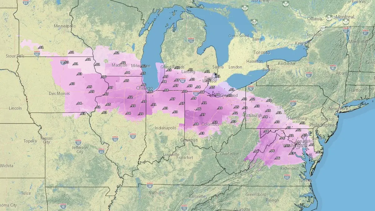
Ice accumulation forecast - 07:00 EST, February 6, 2025. Credit: NWS
- Freezing rain and sleet are expected from Wednesday to Thursday across the Midwest, Great Lakes, and Mid-Atlantic, creating hazardous travel conditions.
- The heaviest ice accumulation (over 6 mm / 0.25 inches) is likely in western Maryland, the West Virginia Panhandle, and parts of Pennsylvania, with risks of power outages and tree damage.
- Dangerous road conditions are anticipated as even minor ice accretion can lead to travel disruptions; drivers are advised to check conditions and exercise caution.
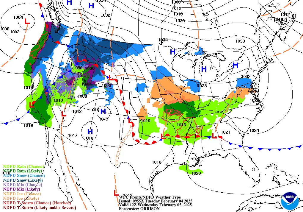
An Arctic high-pressure system will push southward across the northern Plains and Midwest through Wednesday, bringing colder air into the Great Lakes and Northeast in the wake of a departing cold front.
This cold airmass, though gradually moderating, will be in place ahead of a developing storm system that will track into the Ohio Valley and Mid-Atlantic by Wednesday night. The interaction of this system with lingering subfreezing air is expected to produce a mix of precipitation, including snow, sleet, and freezing rain.
The highest probability of significant ice accretion — ranging from 40 to 70% for amounts exceeding 6 mm (0.25 inches) — is forecast across western Maryland, the West Virginia Panhandle, and central to southern Pennsylvania. These areas are at the greatest risk for scattered power outages and tree damage due to ice buildup.
Lighter freezing rain, with accumulations below 6 mm (0.25 inches), is expected across a broader region, including parts of the Midwest, the Great Lakes, and the northern Mid-Atlantic.
Road conditions are expected to deteriorate due to ice accumulation, making travel hazardous.

Remember, even minor ice accretion on roadways can lead to dangerous conditions, particularly on untreated surfaces. Drivers in affected regions are advised to check road conditions before traveling and to proceed with caution.
The storm system will move eastward by late Thursday, with improving conditions expected by Friday. However, the lingering effects of ice accumulation may continue to impact travel and power infrastructure in the hardest-hit areas.
References:
1 Short Range Forecast Discussion – NWS/WPC – February 4, 2025
2 Key Messages for the upcoming freezing rain event to span from the Midwest to the Mid-Atlantic – NWS/WPC – February 4, 2025

I am an Assistant Editor and Severe Weather & Science Journalist at The Watchers, specializing in real-time severe weather coverage, geophysical event reporting, and research-driven scientific analysis. You can reach me at rishav(at)watchers(.)news.
Commenting rules and guidelines
We value the thoughts and opinions of our readers and welcome healthy discussions on our website. In order to maintain a respectful and positive community, we ask that all commenters follow these rules.