
Freezing rain expected north of Philadelphia and surrounding regions
A Winter Weather Advisory has been issued for parts of eastern Pennsylvania, including Upper Bucks, Lehigh, and Northampton counties north of Philadelphia, as well as portions of New Jersey, New York, Connecticut, Massachusetts, Vermont, and New Hampshire. The advisory is in effect from late Friday, December 27, to Saturday, December 28, 2024, with freezing rain expected to impact these areas, creating hazardous travel conditions and the potential for ice accumulation.
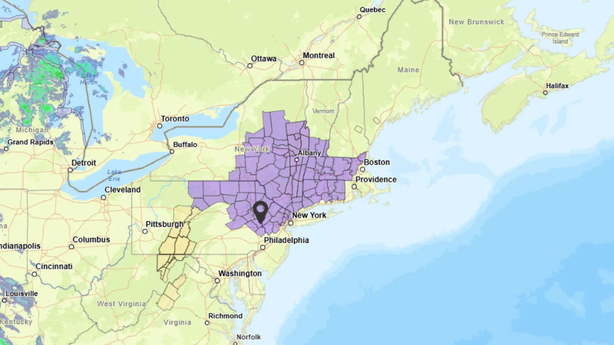
Map of areas under Winter Weather Advisory. Image credit: NWS
A Winter Weather Advisory has been issued for Upper Bucks, Lehigh, and Northampton counties north of Philadelphia, PA from Friday, December 27, at 19:00 local time (LT) through Saturday, December 28, at 09:00 LT, due to anticipated freezing rain during this period.
Total ice accumulations are expected to range from a light glaze to up to 2.5 mm (one-tenth of an inch). Roads, especially bridges and overpasses, are likely to become slick and hazardous. Very slippery conditions on sidewalks, roads, and bridges are possible. Drivers are advised to slow down and exercise caution while traveling.
If you need to go outside, take extra care with your first steps on stairs, sidewalks, and driveways, as these surfaces may be icy and slippery, increasing the risk of falls and injuries. Slow down and use caution when driving or walking in affected areas.
Temperatures are expected to remain at around around -2 °C (20+ °F) through early Friday, rising to 4- 9 °C (40s °F) by the afternoon. Rainfall is anticipated as moisture moves into the region on Saturday. Although Saturday is forecasted to be the wettest day of the weekend, there will be breaks in the rain, with temperatures hovering around 10 – 15 °C (50s °F ).
Overnight, areas north and west of Philadelphia will experience temperatures dipping to around freezing, potentially leading to freezing rain in some locations.
Temperatures will rise to 16 – 20 °C (60s °F) on Sunday, December 29. While most of the day is expected to remain dry, some precipitation is possible during the night.
Temperatures will remain in the upper around 14 – 16 °C (50s °F) ahead of New Year’s Eve on Monday, December 30, with some rain expected in the morning. Additional rain is anticipated during the evening of New Year’s Eve, Tuesday, December 31, with temperatures remaining around 13 °C (mid-50s °F) throughout the day.
Meanwhile, the northwestern United States will continue to experience a stormy weather pattern over the coming days as a series of storm systems move inland from the Pacific. Heavy precipitation has already been observed across the Northern Rockies and Pacific Northwest in the past 24 hours, and this trend will persist.
Today, Northern California and the Pacific Northwest are expected to receive another significant round of precipitation, which will extend into the Northern Rockies. Additional storms will bring further heavy rainfall and snowfall to the region through Sunday and into Monday.
By the end of the weekend, rainfall amounts are expected to reach 75 – 125 mm (3 – 5 inches) across the Washington and Oregon Cascades, the northwest California coastal mountains, and the northern Sierra. Snowfall of 30 – 90 cm (1 – 3 feet) is likely in the highest elevations. This extended period of wet weather is expected to elevate stream flows, increase soil saturation, and heighten the risks of river flooding, as well as rock and mudslides.
In the Lower Mississippi Valley, Tennessee Valley, Southern Appalachians, and Mid-Atlantic, wet weather is forecast to intensify over the next few days. Precipitation will expand northward into the Upper Mississippi Valley today and move eastward into the Southern Appalachians on Saturday, eventually reaching the Mid-Atlantic and Northeast by Saturday night and Sunday.
While drought conditions have shown some improvement across parts of the South and East in recent weeks, many areas still face precipitation deficits. The anticipated rainfall is expected to be hydrologically beneficial, particularly for regions that remain below average in rainfall.
Despite the stormy conditions, Arctic air will remain absent from the Lower 48 as west-to-east atmospheric flow keeps cold air confined north of the U.S./Canada border. Most of the United States will experience much above average temperatures in the coming days.
This warm pattern will continue west of the Mississippi River and represents a reversal for areas east of the river, which have generally experienced below average temperatures in December.
The elevated temperatures could lead to record-high morning low temperatures across the Central Plains and Mid-to-Upper Mississippi Valley today, extending into the Upper Mississippi Valley and Great Lakes region on Saturday, and the Mid-Atlantic and Northeast on Sunday.
References:
1 Philadelphia weather: Potential for freezing rain ahead of weekend rain, warmup – Fox 29 – December 26, 2024
2 Short Range Forecast Discussion – NWS/WPC – December 27, 2024

I am an Assistant Editor and Severe Weather & Science Journalist at The Watchers, specializing in real-time severe weather coverage, geophysical event reporting, and research-driven scientific analysis. You can reach me at rishav(at)watchers(.)news.
Commenting rules and guidelines
We value the thoughts and opinions of our readers and welcome healthy discussions on our website. In order to maintain a respectful and positive community, we ask that all commenters follow these rules.