
Francine makes landfall in Louisiana as Category 2 hurricane, leaving almost 400 000 without power
Making landfall in Louisiana as a Category 2 hurricane on Wednesday, September 11, 2024, Francine battered the state with gusts reaching 169 km/h (105 mph) and torrential rainfall. The storm knocked out power to hundreds of thousands and prompted rescue operations in the flood-ravaged New Orleans metro area.
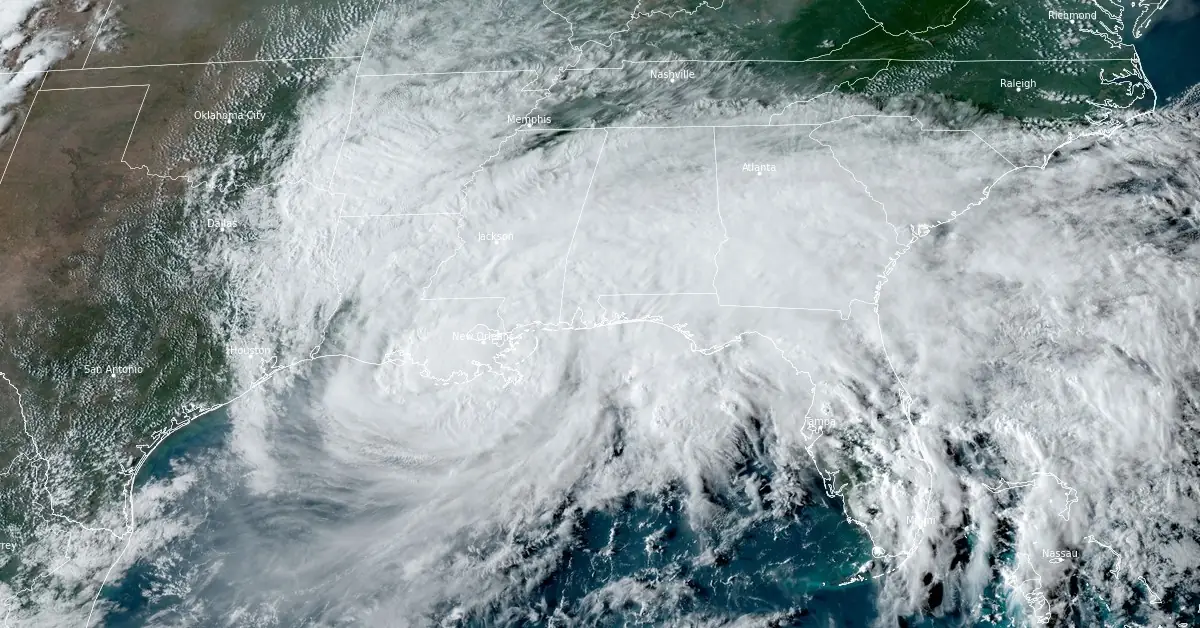
Featured image: 00 UTC on September 11, 2024. Credit: NOAA/GOES-East, RAMMB/CIRA, The Watchers
- Category 2 Hurricane “Francine” made landfall in southern Louisiana, in Terrebonne Parish, approximately 48 km (30 miles) south-southwest of Morgan City.
- Maximum sustained winds at the time of landfall were estimated near 155 km/h (100 mph).
- The hurricane knocked out power to hundreds of thousands of homes and businesses in the region. By Thursday morning, nearly 400 000 customers were without power in Louisiana, and an additional 17 000 were affected in Mississippi.
- Heavy rainfall accompanied the storm, leading to a Flash Flood Emergency in parts of the New Orleans metro area. In just nine minutes, 12.7 mm (0.50 inches) of rain fell, while 114 mm (4.5 inches) fell in over three hours. The flooding posed life-threatening risks, prompting rescue operations.
Hurricane “Francine” made landfall in Terrebonne Parish, Louisiana, at 22:00 UTC on Wednesday, September 11, as a Category 2 hurricane with maximum sustained winds of 161 km/h (100 mph). The storm quickly weakened after landfall and was downgraded to a tropical storm by 03:00 UTC on Thursday, September 12.
At landfall, the storm caused significant damage in coastal areas. Winds exceeding 161 km/h (100 mph) were recorded, with Eugene Island reporting gusts as high as 169 km/h (105 mph). Dulac experienced gusts of 156 km/h (97 mph), while New Orleans saw wind speeds of 126 km/h (78 mph) and 122 km/h (76 mph) as Francine’s eyewall moved through the city.
The hurricane knocked out power to hundreds of thousands of homes and businesses in the region. By Thursday morning, nearly 400 000 customers were without power in Louisiana, and an additional 17 000 were affected in Mississippi, according to PowerOutage.us.
Heavy rainfall accompanied the storm, leading to a Flash Flood Emergency in parts of the New Orleans metro area. In just nine minutes, 12.7 mm (0.50 inches) of rain fell, while 114 mm (4.5 inches) fell in over three hours. The flooding posed life-threatening risks, prompting rescue operations.
One New Orleans East business owner says he constantly has to come out after storms to manually unclog catch basins to prevent his business from flooding. Here he is doing so after #Francine to relieve an inundated Chef Hwy @FOX8NOLA pic.twitter.com/4vzyCr8UND
— David Jones (@DavidJonesTV) September 12, 2024
Catastrophic flooding here in Metairie at my house. Absolutely nuts! It hasn’t flooded like this since Katrina! #HurricaneFrancine #Francine pic.twitter.com/dEvk0FZge5
— Karson (@KarsonRhodes_wx) September 12, 2024
Lafourche Parish Sheriff Craig Webre reported that more than two dozen individuals, including small children, were rescued from floodwaters in Thibodaux. “All the residents were safely evacuated from the area, and most were taken to emergency shelters,” authorities confirmed.
New Orleans International Airport reported 186 mm (7.33 inches) of rain on Wednesday, making it the second-wettest September day on record and the ninth-wettest day overall since 1946. Due to the storm, flights in and out of the airport were canceled through Thursday morning.
Despite Francine weakening into a tropical storm, the National Hurricane Center (NHC) warned that dangerous conditions would persist, including the risk of tornadoes and severe thunderstorms. The storm’s effects were felt beyond Louisiana, with Wind Advisories, Flood Watches, and hazardous weather alerts posted as far north as southern Missouri and as far east as Tennessee.
Francine is expected to bring 76 – 152 mm (3 – 6 inches) of rainfall across Mississippi, Alabama, and the Florida Panhandle, with localized amounts of up to 254 mm (10 inches) possible. The NHC noted that this could lead to “locally considerable flash and urban flooding.”
Power outages continued to climb throughout Wednesday night and into Thursday morning. As of early Thursday, 391 000 customers were without power in Louisiana, with more than 41 000 in Mississippi. Terrebonne and St. Mary Parishes, where the storm made landfall, were among the hardest hit by blackouts and flooding.
Morgan City, located in St. Mary Parish, experienced severe flooding as Francine pushed storm surge inland. “It’s a little bit worse than what I expected to be honest with you. I pulled all my trucks back to the station; it’s too dangerous to be out there in this.” Said Morgan City Fire Chief Alvin Cockerham.
St. Mary Parish Sheriff’s Office reported damage to homes, downed trees, and power lines. Det. Lt. David Spencer said the area saw “more flooding than originally predicted.” Roofs of several homes were damaged, but there were no immediate reports of injuries.
Ahead of Francine’s landfall, Louisiana Governor Jeff Landry declared a state of emergency and requested federal assistance. President Joe Biden approved the request, stating that the storm’s severity exceeded the state’s ability to respond effectively. Governor Landry said, “This federal assistance is needed to save lives and property.”
The Louisiana National Guard was deployed to assist with search-and-rescue operations. The Guard mobilized nearly 400 high-water vehicles, about 100 boats, and 50 helicopters for emergency response efforts in affected areas.
As of Thursday morning, Francine was centered about 97 km (60 miles) north of New Orleans, with maximum sustained winds of 72 km/h (45 mph). The storm was moving northeast at 19 km/h (12 mph), continuing to weaken as it traveled inland.
The NHC expects Francine to bring heavy rainfall and wind across Mississippi, Alabama, Georgia, and the Florida Panhandle as it progresses northward. Although weakening, the storm still poses a risk for flash flooding and power outages in these areas.
8 pm CDT – Hurricane #Francine is producing heavy rains and gusty winds across New Orleans. Stay inside and away from windows and have multiple ways to receive warnings and updates. Next forecast will be issued by 10 pm CDT. Visit https://t.co/tW4KeGe9uJ pic.twitter.com/IN71iMnQbY
— National Hurricane Center (@NHC_Atlantic) September 12, 2024
Francine further weakened to a tropical depression at 12:00 UTC on September 12 when its center was located about 50 km (31 miles) S of Jackson, Mississippi. The storm had maximum sustained winds of 55 kn/h (35 mph) and a minimum central pressure of 996 hPa.
The system is moving toward the north-northeast at approximately 19 km/h (12 mph). A turn toward the north is expected during the next day or so, with some decrease in forward speed.
On the forecast track, the center of Francine will move over central and northern portions of Mississippi through early Friday, September 13.
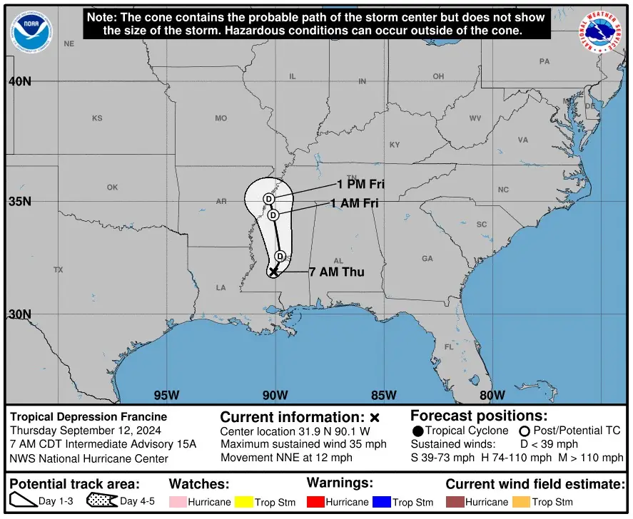
Continued weakening is forecast, and Francine is expected to become a post-tropical cyclone later today.
A few tornadoes are possible today, mainly this morning and afternoon from the Florida Panhandle to north-central Alabama.
In addition, swells generated by the storm will continue to affect much of the northern Gulf coast through today. These swells are likely to cause life-threatening surf and rip current conditions.
Francine is the eighth hurricane to make landfall in the state since 2000 and 57th since the mid-19th century.
References:
1 Francine lashes Louisiana, leaves hundreds of thousands without power – CBS – September 12, 2024
2 Ferocious Francine slams Louisiana ripping roofs from buildings, trapping residents amid rising floodwaters – Fox Weather – September 11, 2024
3 Tropical Depression Francine – Intermediate Advisory Number 15A – NWS/NHC – Issued at 12:00 UTC on September 12, 2024

I am an Assistant Editor and Severe Weather & Science Journalist at The Watchers, specializing in real-time severe weather coverage, geophysical event reporting, and research-driven scientific analysis. You can reach me at rishav(at)watchers(.)news.
Commenting rules and guidelines
We value the thoughts and opinions of our readers and welcome healthy discussions on our website. In order to maintain a respectful and positive community, we ask that all commenters follow these rules.