
Rex block shatters multiple records in Canada
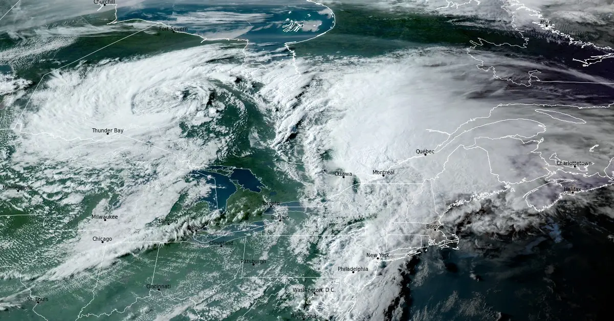
Image credit: NOAA/GOES-East, RAMMB/CIRA, The Watchers. Acquired at 22:10 UTC on August 9, 2024
Canada experienced a week of extraordinary weather, breaking multiple records for heat and rainfall across the country. A unique atmospheric pattern, known as a Rex block, caused temperatures to soar in the Arctic Circle, while remnants of Hurricane “Debby” brought torrential rains to Eastern Canada.
Communities in the Northwest Territories recorded Canada’s hottest temperatures multiple times this week. Temperatures surged into the mid-30s °C (mid-90s °F) deep within the Arctic Circle, an area typically associated with much cooler temperatures.
Fort Good Hope recorded a scorching 37 °C (98.6 °F), marking the highest temperature ever recorded during August in the Northwest Territories. Little Chicago, N.W.T., reached 36 °C (96.8 °F) several times, setting the highest temperature ever recorded in the region. Inuvik also experienced record heat, with temperatures soaring to 34.8 °C (94.6 °F)—nearly double the average seasonal high for early August.
This intense heatwave persisted for four consecutive days, with temperatures remaining in the lower 30s °C (lower 90s °F) through the weekend. Remarkably, these temperatures were 10 °C (18 °F) higher than those recorded in the southernmost parts of Canada.
While the North endured record-breaking heat, Eastern Canada faced a deluge of rain. The remnants of Hurricane “Debby” brought significant rainfall to the region, particularly in areas not typically hardest hit by such storms. Montreal experienced its wettest day on record on August 9, 2024, with 158 mm (6.2 inches) of rain falling at Montreal Airport. This surpassed the previous record of 87.6 mm (3.4 inches) set in 1880.
The torrential downpour led to widespread flooding across Quebec, with many communities recording rainfall totals well over 100 mm (3.9 inches), and some nearing 200 mm (7.9 inches) by the time the storm subsided early on August 10.
The unusual weather was driven by a Rex block, a rare atmospheric phenomenon where a high-pressure system becomes trapped north of a low-pressure system, causing stagnation in weather patterns. This led to extreme conditions being locked in place for several days, resulting in historic heat in the North and the unusual track of remnants of Hurricane “Debby” remnants, which brought heavy rainfall to interior sections of Eastern Canada.
As the week ended, cooler air moved into southern Canada, bringing relief from the heat, while the North began to see a slight easing of temperatures.
Reference:
1 All-time records shattered as Canada’s weather turns upside down – TWN – August 11, 2024

I am an Assistant Editor and Severe Weather & Science Journalist at The Watchers, specializing in real-time severe weather coverage, geophysical event reporting, and research-driven scientific analysis. You can reach me at rishav(at)watchers(.)news.
Commenting rules and guidelines
We value the thoughts and opinions of our readers and welcome healthy discussions on our website. In order to maintain a respectful and positive community, we ask that all commenters follow these rules.