
Tropical Storm “Harold” hits South Texas, marking the first U.S. hit of the 2023 Atlantic hurricane season
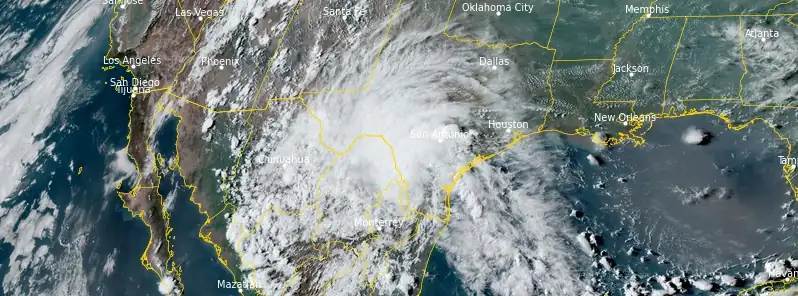
Featured image: Tropical Storm "Harold" at 22:50 UTC on August 22, 2023. Credit: NOAA/GOES-East, RAMMB/CIRA, The Watchers
Tropical Storm “Harold” — the first Atlantic tropical cyclone to make landfall in the US for 2023, hit South Texas on Tuesday, August 22, 2023, delivering torrential rains and localized flash floods in areas along the Mexico border. This sudden impact came mere hours after its upgrade from a tropical depression on its trajectory across the Gulf of Mexico.
Tropical Storm “Harold” made landfall on Padre Island, Texas at around 15:00 UTC on August 22, 2023, within just 12 hours of its designation as a tropical storm. At the time of landfall, the system had maximum sustained winds of 85 km/h (50 mph) and minimum central pressure of 998 hPa.
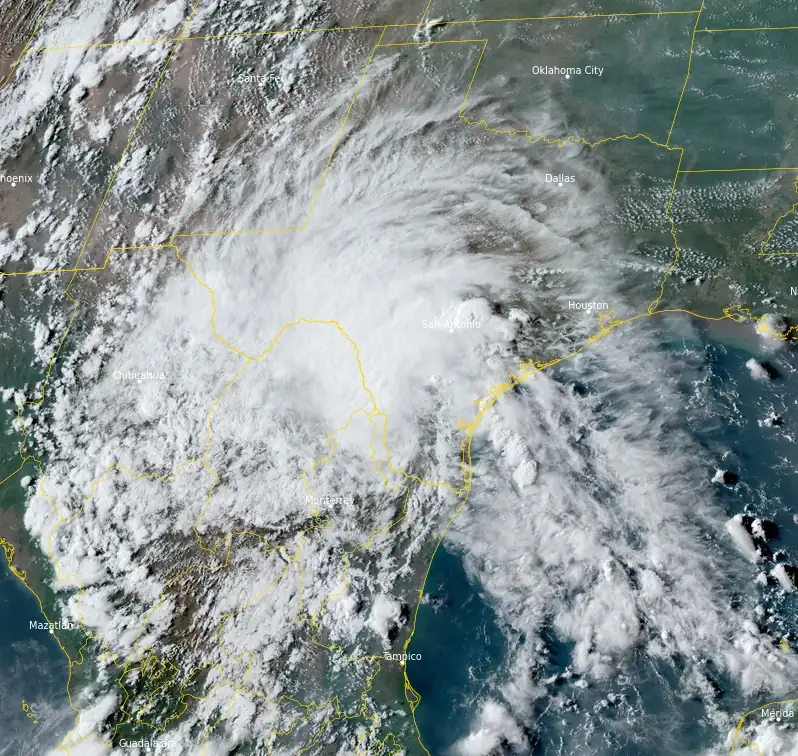
Post landfall, Harold’s wind intensity began to diminish, relegating it to a tropical depression by Tuesday afternoon (LT). As the storm proceeds, it is expected to transform into a tropical rainstorm and move northwestward along the Rio Grande River on Wednesday.
25 to 100 mm (1 – 4 inches) of rainfall has already been recorded across numerous locales in South Texas. Specifically, Corpus Christi reported an accumulation of 120 mm (4.74 inches) as of 03:00 local time on Wednesday. Though the primary rainband ceased along the South Texas coast on Tuesday evening, areas northwest of Laredo, Texas, continued to witness flooding downpours.
Harold’s heaviest rainfall is anticipated in the mountainous terrains of northern Mexico and potentially in Texas’s Big Bend area along the Rio Grande River.
Harold is expected to produce rainfall amounts of 25 to 50 mm (1 to 2 inches) with isolated higher amounts of 100 mm (4 inches) across the Big Bend and Trans Pecos regions of Texas as well as southern New Mexico through tonight. Isolated to widely scattered instances of flash flooding are possible. In far northern Mexico, rainfall amounts of 100 to 150 mm (4 to 6 inches), with local amounts of 250 mm (10 inches) are expected today. Scattered instances of flash flooding are expected with landslides possible.
While this rainfall may alleviate the prevailing drought in certain parts of South Texas, regions bearing the brunt of the drought, notably southeastern and central Texas, may not receive adequate relief. The arid land in southern Texas might struggle to absorb the tropical downpours, enhancing the risk of flash floods, as highlighted by AccuWeather Senior Meteorologist Courtney Travis.
The coastal influences of Harold, such as winds and tides, will likely abate as it ventures further inland through Wednesday. Interactions with the challenging terrains in northern Mexico are projected to further diminish Harold’s wind intensity, rendering it an untrackable feature by midweek. Still, remnants of Harold’s tropical moisture may persist. This residual moisture could be channeled northwestward, subsequently moving north into regions like western Texas, New Mexico, and potentially eastern Arizona. This moisture-laden system will encircle the southern and western peripheries of a substantial heat dome settled over the nation’s midsection. However, this rain’s extent might contract with time.
El Paso, Texas, which previously evaded the downpours linked to Tropical Storm Hilary, was hit by Harold’s rain and thunderstorms late on Tuesday. These heavy showers could induce localized flash floods. Moreover, the widespread cloud cover and rain may ensure that temperatures remain below 32 °C (80s °F) for the first time since early June, marking potentially the coolest El Paso daytime temperatures since April or May.
Interestingly, before acquiring the status of a depression, Harold, in its formative tropical rainstorm stage, had unleashed downpours and isolated thunderstorms on the Bahamas and the Florida Peninsula last week. The Florida Keys documented a general precipitation of 50 – 75 mm (2 – 3 inches), while drought-afflicted zones along Florida’s west coast reported 6 – 25 mm (0.25 to 1 inch) of rain.
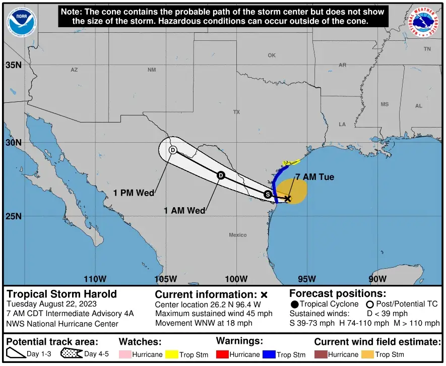
At 09:00 UTC on August 23, the center of Tropical Depression “Harold” was located about 380 km (235 miles) S of Midland, Texas and about 545 km (340 miles) SE of El Paso, Texas.
It had maximum sustained winds of 45 km/h (30 mph) and minimum central pressure of 1 005 hPa.
The depression is moving toward the west-northwest near 22 km/h (14 mph) and this motion is expected to continue with some acceleration into Thursday morning
In addition to heavy rain, gusty winds are possible in the Big Bend and Trans Pecos regions of Texas, southern New Mexico, and northernmost Mexico through tonight. Winds could be particularly gusty in and near areas of elevated terrain. Higher gusts could persist even after the system dissipates.
References:
1 Tropical Depression Harold – Advisory Number 8 – NWS Weather Prediction Center College Park MD AL092023 – 400 AM CDT Wed Aug 23 2023
2 Harold to transition to tropical rainstorm, following first US landfall of 2023 – AccuWeather – August 23, 2023
The Watchers team and our contributors bring the latest on extreme weather, earthquakes, volcanic eruptions, space weather, and all things science. We're all about making sense of the natural world and keeping you informed on what’s happening. Got a tip or a question? Hit us up using the form at newstips!
Commenting rules and guidelines
We value the thoughts and opinions of our readers and welcome healthy discussions on our website. In order to maintain a respectful and positive community, we ask that all commenters follow these rules.