
Hilary becomes the fourth tropical storm or hurricane to reach California intact, brings record-breaking rains

Image credit: Office of the Governor of California
Tropical Storm “Hilary” — previously a Category 4 hurricane — reached California on August 20, 2023, marking its position as one of the rare storms to maintain integrity upon reaching the state. The storm, with surface winds over 80 km/h (50 mph), brought with it record-breaking rainfall and caused widespread flooding and power outages across the region.
- Post-Tropical Cyclone “Hilary” is forecast to continue its track north into the heart of the Great Basin today, spreading heavy rainfall and high wind gusts throughout the West on Monday. Accordingly, isolated to scattered instances of flash flooding are possible today across much of the West, where a Slight Risk of Excessive Rainfall is in effect.
After crossing into California on August 20, Tropical Storm “Hilary” marked a historic event as it became only the fourth tropical storm or hurricane to remain intact upon reaching the state, with its effects being the most pronounced in nearly 85 years. Historical comparisons include Hurricane Nora in 1997, the Long Beach tropical storm in 1939, and the San Diego hurricane in 1858.
High winds were noted in the mountains east of San Diego and northern Los Angeles County, with gusts at higher elevations ranging from 1.2 to 1.8 km (4 000 to 6 000 feet) exceeding 130 km/h (80 mph). However, the paramount impact came from the torrential rainfall.
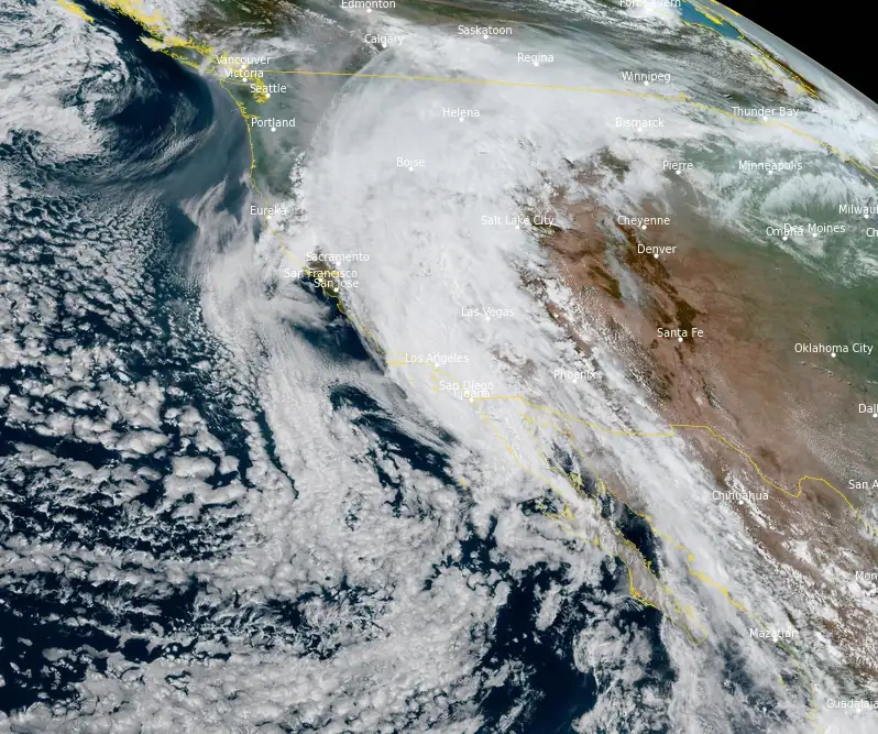
Accumulations surpassed 178 mm (7 inches) in parts of northern Los Angeles County within a few days, breaking nearly all prior daily rainfall records for a region unaccustomed to rain in August. San Bernardino County witnessed boulders on roadways, and multiple semi-trucks overturned on Interstate 8 near Gordon’s Well, as recorded by the National Weather Service. Near Forest Falls, California, rainfall from Hilary amounted to 266.9 mm (10.51 inches).
Power disruptions affected large swathes of the state, with a peak of 57 000 customers without electricity on Monday morning, August 21.
Hilary’s extensive reach led to the closure of parks in three states, disrupted air travel, and resulted in over 1 000 flight cancellations on Sunday. Orange and San Diego counties saw all state beaches and parks shut down. Governor Newsom had proclaimed a state of emergency on the preceding Saturday in anticipation of Hilary’s landfall. Among the widespread flooding, storm chasers reported inundation in Ocotillo, California, early Sunday afternoon. Los Angeles, housing the nation’s largest school district, remained closed on Monday.
While the mountain ranges of the west began dissipating Hilary’s circulation, residual heavy rain continued in its wake. Notwithstanding the current challenges, improvements in conditions across southern California are anticipated, especially by later today and into Tuesday. This will pave the way for officials to start the damage assessment process.
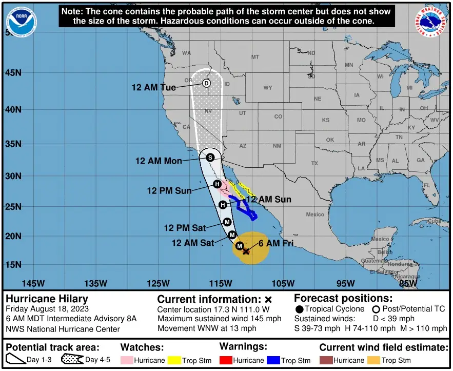
Before hitting California, Hilary, which rapidly intensified into a Category 4 hurricane since it formed on August 16, made landfall in the northern part of the Baja California Peninsula, Mexico. This event tragically resulted in a fatality near Santa Rosalia, Mexico, caused by floodwaters.
At 15:00 UTC on August 21, the center of Post-Tropical Cyclone “Hilary” was located about 180 km (115 miles) WNW of Elko, Nevada. The system had maximum sustained winds of 55 km/h (35 mph) and minimum central pressure of 1 004 hPa. It was moving NNE at 39 km/h (24 mph) and this motion is expected to continue before the circulation dissipates later today (LT).
Rainfall will be diminishing across coastal Southern California on Monday. Additional rainfall totals up to 25 mm (1 inch) are possible. Hilary is expected to produce additional rainfall amounts of 25 to 76 mm (1 to 3 inches) across portions of southeast California and southern Nevada through Monday, with isolated storm total amounts up to 305 mm (12 inches). Continued flash and urban flooding is expected.
Across portions of Oregon and Idaho, rainfall totals of 25 to 76 mm (1 to 3 inches) with local maxima to 127 mm (5 inches) are expected through Tuesday morning, resulting in localized, some significant, flash flooding.
Flood Watches are in effect for:
- Southern California
- Northwest Arizona
- Much of Nevada
- Southwest Utah
- Eastern Oregon
- Western and Central Idaho
- Far Southeast Washington
Hilary is still expected to produce strong, gusty winds today in Nevada, western Utah, southern Idaho, and southwest Montana. The strongest gusts would be favored in high terrain, passes, canyons, and summits.
High Wind Warnings and Wind Advisories are in effect for:
- Northern and Central Nevada
- Western Utah
- Southern Idaho
- Southwest Montana
Large swells will continue to affect portions of the Baja California Peninsula and southern California through this morning. These swells are likely to cause life-threatening surf and rip current conditions.
References:
1 Atlantic Sees Historic Tropical Cyclone Outbreak, Hilary Hits Southern California with Devastating Floods – Michael Lowry – August 21, 2023
2 Deadly Hilary hits Mexico, floods parts of Southern California – AccuWeather – August 21, 2023
I'm a dedicated researcher, journalist, and editor at The Watchers. With over 20 years of experience in the media industry, I specialize in hard science news, focusing on extreme weather, seismic and volcanic activity, space weather, and astronomy, including near-Earth objects and planetary defense strategies. You can reach me at teo /at/ watchers.news.
Hilary’s remnants have reached Ohio and are causing flash flooding