
Super Typhoon “Mawar” threatens Guam with direct impact
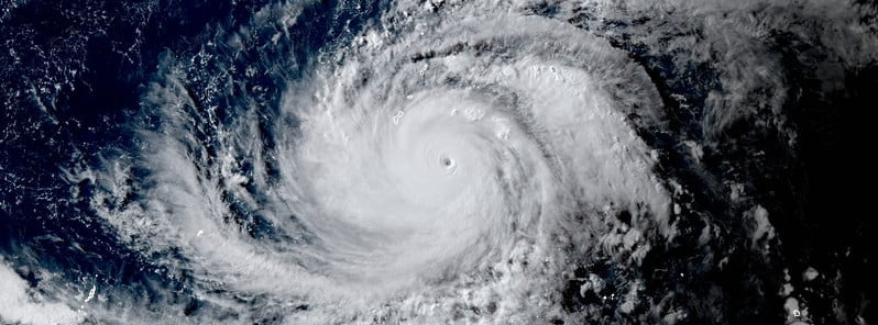
Featured image: Typhoon "Mawar" at 07:10 UTC on May 23, 2023. Credit: JMA/Himawari-9, RAMMB/CIRA, The Watchers
Mawar rapidly intensified into a super typhoon on May 23, 2023, as it continued moving toward Guam where a state of emergency has been declared. There is a possibility Mawar makes a direct hit to the island, resulting in significant damage. This will be the strongest storm to hit the island in 20 years.
- Typhoon Warning remains in effect for Guam and Rota. Damaging winds of 63 km/h (39 mph) or more are expected late this evening (LT), with the onset of typhoon-force winds forecast for Wednesday morning (LT)
- Tropical Storm Warning remains in effect for Saipan and Tinian. Damaging winds of 63 km/h (39 mph) or more are expected tonight into Wednesday morning (LT)
- Typhoon Watch remains in effect for Saipan and Tinian. Typhoon-force winds are possible if the westward turn of Mawar is delayed
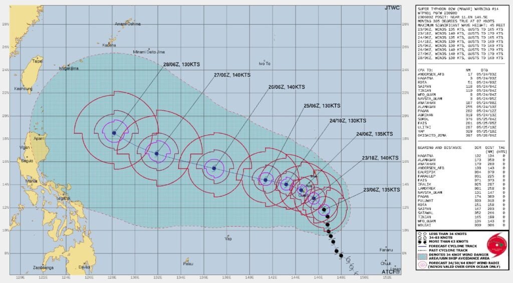
- Mawar will move near or over Guam before 06:00 UTC on May 24
At 09:00 UTC on May 23, the center of Super Typhoon “Mawar” was located about 275 km (170 miles) southeast of Yigo, Guam.
The storm had maximum 10-minute sustained winds of 185 km/h (115 mph), with gusts to 260 km/h (160 mph), while maximum 1-minute sustained winds were at 250 km/h (155 mph).
The minimum central barometric pressure was 935 hPa, and the system was moving north-northwest at 13 km/h (8.1 mph).
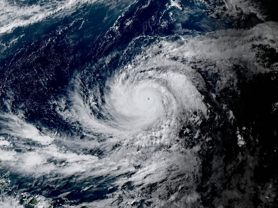
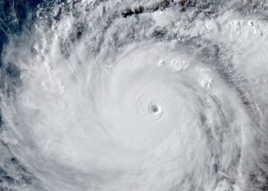
Animated multispectral satellite imagery (MSI) depicts the classic, symmetric cloud pattern typical of a super typhoon, with an outer band along the northern and western peripheries currently approaching Guam and the Northern Mariana Islands, JTWC forecasters said.
Super Typhoon “Mawar” continues to undergo rapid intensification, supported by very favorable upper-level conditions and a warm sea surface. The primary inhibitor to additional near-term intensification is the impact of inner-core dynamics, including the possibility of an eyewall replacement cycle.
The current forecast calls for marginal intensification to 259 km/h (161 mph) over the next 12 hours, and it is all but certain that the system will remain at or near super typhoon intensity prior to the passage of the eye over or near Guam.
Guam Governor Lou Leon Guerrero declared a state of emergency and ordered all residents in low-lying areas of the island to evacuate to shelters on higher ground no later than 18:00 LT today. “Mawar is a real threat and a possible direct hit to our island,” she said.
Along with extremely dangerous winds, rough surf, and coastal flooding, Mawar is bringing heavy rains — up to 250 mm (10 inches) and potentially as much as 500 mm (20 inches), which could result in life-threatening floods and mudslides.
Mawar is likely to bring considerable damage to buildings and homes of light material. Non-concrete roofs can suffer extensive damage, while non-reinforced concrete walls could be blown down. Severe damage to well-built wooden and metal structures is possible.
Electricity and water may be unavailable for days and perhaps weeks after the storm passes. Most trees will be snapped or uprooted.
A storm surge of 1.8 to 3 m (6 to 10 feet) above the normal high tide is expected as Mawar moves overhead on Wednesday. The surge may reach to between 3 and 4.6 m (10 – 15 feet) above normal high tide for the most vulnerable storm surge-prone areas.
In 2002, Typhoon “Pongsona” hit Guam with wind speeds of 241 km/h (150 mph) and resulted in damage worth $1 billion. Typhoon “Mangkhut” in 2018 caused $4.3 million worth of damage while the damage caused by Typhoon “Wutip” in 2019 amounted to approximately $1.3 million.
I'm a dedicated researcher, journalist, and editor at The Watchers. With over 20 years of experience in the media industry, I specialize in hard science news, focusing on extreme weather, seismic and volcanic activity, space weather, and astronomy, including near-Earth objects and planetary defense strategies. You can reach me at teo /at/ watchers.news.
Commenting rules and guidelines
We value the thoughts and opinions of our readers and welcome healthy discussions on our website. In order to maintain a respectful and positive community, we ask that all commenters follow these rules.