
Fiona becomes a Category 4 hurricane, expected to hit Atlantic Canada as a powerful hurricane-force cyclone
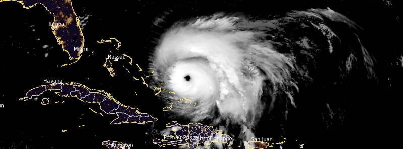
Featured image: Hurricane "Fiona" at 06:50 UTC on September 21, 2022. Credit: NOAA/GOES-East, RAMMB/CIRA, The Watchers
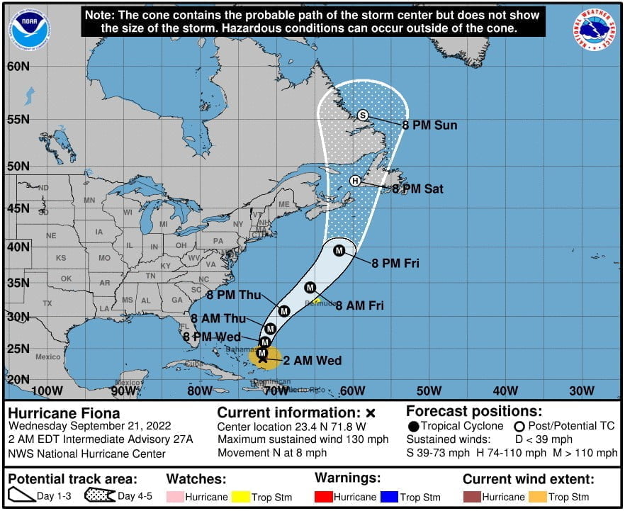
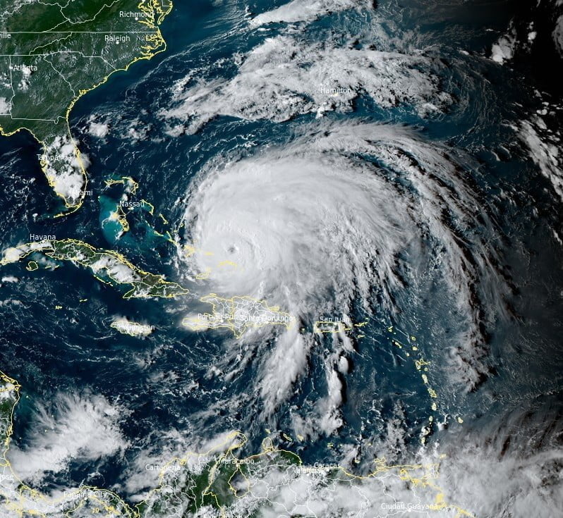
Fiona strengthened into a Category 4 hurricane at 06:00 UTC on Wednesday, September 21, 2022, while moving away from the Turks and Caicos islands. The center of Fiona will continue to move away from the islands today, and approach Bermuda late on Thursday. The system is expected to affect portions of Atlantic Canada as a powerful hurricane-force cyclone late Friday and Saturday.
- Heavy rain will continue impacting the islands through tonight, with additional flooding possible, NHC warns.
- Tropical storm conditions are possible on Bermuda by late Thursday (LT), September 22.
At 06:00 UTC on September 21, the center of Hurricane “Fiona” was located about 170 km (105 miles) N of North Caicos and 1 215 km (755 miles) SW of Bermuda.1
The storm had maximum sustained winds of 210 km/h (130 mph) and minimum central pressure of 13 km/h (8 mph). Additional strengthening is forecast through tonight, with some fluctuations in intensity possible tonight and Thursday.
Fiona is moving toward the north near 13 km/h (8 mph) and this general motion is expected to continue through today.
A turn toward the NNE, with an increase in forward speed, is expected by Thursday.
On the forecast track, the center of Fiona will continue to move away from the Turks and Caicos today, and approach Bermuda late on Thursday.
Gusty winds are likely to continue over portions of the southeastern Bahamas and Turks and Caicos islands overnight. Tropical storm conditions could reach Bermuda by late Thursday or early Friday.
Swells generated by Fiona are affecting the northern coast of Hispaniola, the Turks and Caicos Islands, and the southeastern and central Bahamas. These swells will continue to spread westward across the southwestern Atlantic toward the northwestern Bahamas and the east coast of the United States during the next day or two.
Swells from Fiona are expected to reach Bermuda by early Thursday, causing life-threatening surf and rip current conditions.
Fiona is expected to affect portions of Atlantic Canada as a powerful hurricane-force cyclone late Friday and Saturday, September 23 and 24, and could produce significant impacts from high winds, storm surge, and heavy rainfall, NHC said.
This year, water temperatures have been running 5 to 10 °C (10 – 20 °F) higher than average over the North Atlantic, especially just south of Atlantic Canada, and those warmer-than-usual waters may result in less weakening of the hurricane or a slower transformation to a rainstorm, AccuWeather meteorologists said.2
A dip in the jet stream over eastern Canada late this week will likely allow Fiona to take a path into the Gulf of St. Lawrence, western Newfoundland, or possibly northern Nova Scotia from Friday night to Saturday.
Should the storm track into the Gulf of St. Lawrence, high water levels and significant coastal flooding can occur in the region, and the storm could make a mess for maritime operations in the region.
“Fiona will bring widespread power outages due to high winds, flooding due to torrential rain and isolated storm surge and massive seas offshore and in the Gulf of St. Lawrence,” AccuWeather Senior Meteorologist and Canada Weather Expert Brett Anderson said.
Strong winds from Fiona over the North Atlantic just south of Newfoundland and the Gulf of St. Lawrence can allow swells to build to 12 m (40 feet) or higher.
References:
1 Hurricane Fiona Intermediate Advisory Number 27A – NWS National Hurricane Center Miami FL – 200 AM EDT Wed Sep 21 2022
2 Hurricane Fiona to slam into Atlantic Canada head-on after sideswiping Bermuda – AccuWeather – Setepbmer 20/21, 2022.
I'm a dedicated researcher, journalist, and editor at The Watchers. With over 20 years of experience in the media industry, I specialize in hard science news, focusing on extreme weather, seismic and volcanic activity, space weather, and astronomy, including near-Earth objects and planetary defense strategies. You can reach me at teo /at/ watchers.news.
Commenting rules and guidelines
We value the thoughts and opinions of our readers and welcome healthy discussions on our website. In order to maintain a respectful and positive community, we ask that all commenters follow these rules.