
Lisa forecast to make landfall over Belize as a hurricane
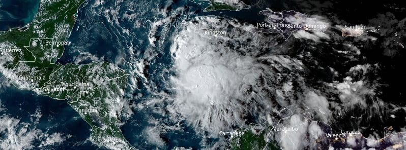
Featured image: Tropical Storm "Lisa" at 21:30 UTC on October 31, 2022. Credit: NOAA/GOES-East, RAMMB/CIRA, The Watchers
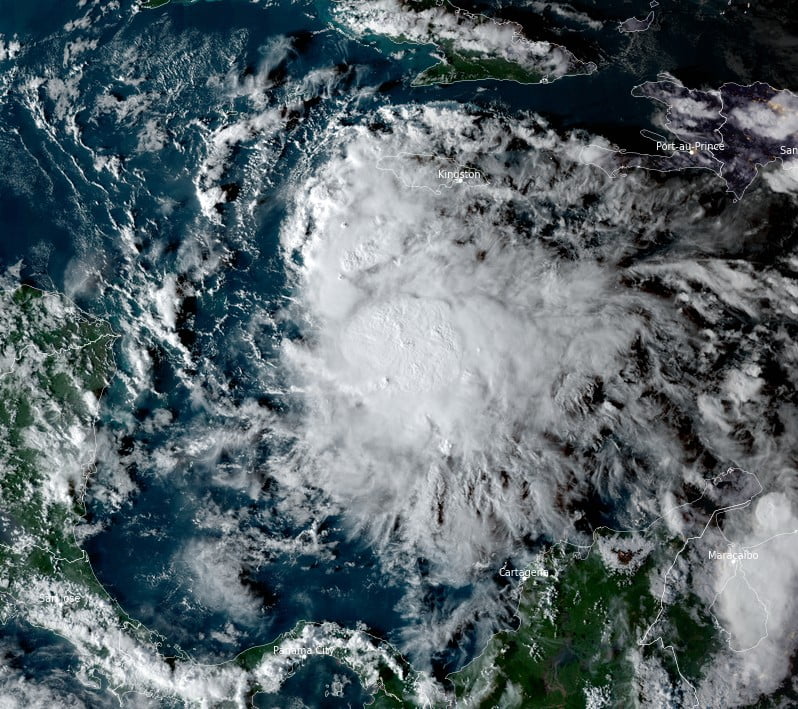
Tropical Storm “Lisa” formed in the Caribbean Sea at 15:00 UTC on October 31, 2022, as the 12th named storm of the 2022 Atlantic hurricane season. At the time, Lisa’s center was located about 285 km (175 miles) south of Kingston, Jamaica. The system is expected to strengthen into a hurricane before making landfall over Belize on November 2.
- Hurricane conditions are possible in the Bay Islands of Honduras early Wednesday, November 2, and along the coast of Belize by Wednesday afternoon, where a Hurricane Watch is in effect
- Tropical storm conditions are expected along portions of the north coast of Honduras, where a Tropical Storm Warning has been issued. A Tropical Storm Watch is in effect for the remainder of the coast of Honduras, the Caribbean coast of Guatemala, and the southeastern Yucatan Peninsula of Mexico, where tropical storm conditions are possible
- Localized flash flooding is expected across portions of the eastern Yucatan Peninsula, Belize, and northern Honduras, including the Bay Islands, starting late Tuesday and continuing through Thursday
- There is potential for a dangerous storm surge near where the core of Lisa crosses the coast of Belize
At 06:00 UTC on November 1, the center of Tropical Storm “Lisa” was located about 415 km (260 miles) SSE of Grand Cayman and 915 km (570 miles) E of Belize City, Belize, according to the National Hurricane Center (NHC).1
It had maximum sustained winds of 75 km/h (45 mph) and a minimum central pressure of 1 004 hPa.
It was moving W at 19 km/h (12 mph) and this motion is expected to continue over the next few days.
On the forecast track, Lisa’s center will pass south of the Cayman Islands today, move near or over the Bay Islands of Honduras early November 2 (LT), and approach Belize later in the day.
The environmental conditions appear relatively favorable for Lisa to strengthen during the next 36 to 48 hours. Sea surface temperatures are quite warm beneath the cyclone and the vertical wind shear is expected to be low to moderate.2
There is some dry air near the system, however, which might slow the rate of intensification.
The NHC intensity forecast follows the trend of the consensus models and continues to show Lisa becoming a hurricane when it is over the Gulf of Honduras early Wednesday, and it is expected to maintain that intensity when it makes landfall.
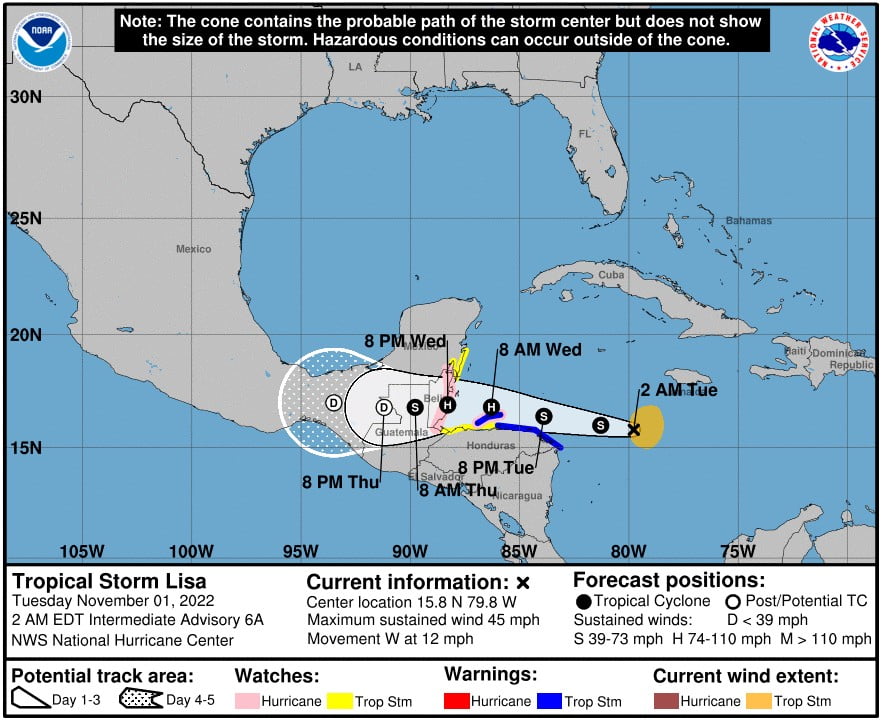
A Tropical Storm Warning is in effect for Bay Islands; Honduras from the border with Nicaragua to Punta Castilla.
A Tropical Storm Watch is in effect for the coast of Honduras from west of Punta Castilla westward to the Guatemala border; Guatemala from the border with Honduras to Puerto Barrios; Mexico from Chetumal to Punta Herrero
Hurricane conditions are possible in the Bay Islands of Honduras beginning early Wednesday and are possible along the coast of Belize Wednesday afternoon.
Tropical storm conditions are expected along the northeastern coast of Honduras within the Tropical Storm Warning area tonight and Wednesday.
Tropical storm conditions are possible in the Tropical Storm Watch area in Mexico, Honduras, and Guatemala Wednesday afternoon.
Through Thursday evening, November 3, Lisa is expected to produce the following rainfall amounts:
- 75 – 128 mm (3 to 5 inches) with local amounts to 200 mm (8 inches) across portions of Belize and the Bay Islands of Honduras
- 50 – 100 mm (2 to 4 inches) with local amounts to 150 mm (6 inches) across portions of Northern Honduras, Jamaica, Guatemala and the eastern Yucatan peninsula
- 50 mm (1 inch) with local amounts to 100 mm (2 inches) across portions of the Cayman Islands, eastern Nicaragua.
This rainfall could produce flash floods from northern Honduras northward to the eastern Yucatan Peninsula.
A storm surge could raise water levels by as much as 0.9 to 1.5 m (3 to 5 feet) above normal tide levels along the immediate coast of Belize in areas of onshore winds and 0.3 – 0.9 m (1 to 3 feet) for the Bay Islands of Honduras.
Near the coast, the surge will be accompanied by large and damaging waves.
Swells generated by Lisa are expected to affect Jamaica and the Cayman Islands during the next day or so, and will begin to affect Central America later today. These swells could cause life-threatening surf and rip current conditions.
References:
1 Tropical Storm Lisa Intermediate Advisory Number 6A – NWS National Hurricane Center Miami FL – 200 AM EDT Tue Nov 01 2022
2 Tropical Storm Lisa Discussion Number 6 – NWS National Hurricane Center Miami FL – 1100 PM EDT Mon Oct 31 2022
I'm a dedicated researcher, journalist, and editor at The Watchers. With over 20 years of experience in the media industry, I specialize in hard science news, focusing on extreme weather, seismic and volcanic activity, space weather, and astronomy, including near-Earth objects and planetary defense strategies. You can reach me at teo /at/ watchers.news.
Commenting rules and guidelines
We value the thoughts and opinions of our readers and welcome healthy discussions on our website. In order to maintain a respectful and positive community, we ask that all commenters follow these rules.