
Subtropical Storm “Nicole” forecast to strengthen into a hurricane before reaching Florida, U.S.
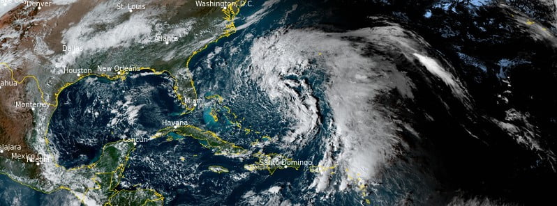
Featured image: Subtropical Storm "Nicole" at 20:20 UTC on November 7, 2022. Credit: NOAA/GOES-East, RAMMB/CIRA, The Watchers
Subtropical Storm “Nicole” formed northeast of the Bahamas at 09:00 UTC on November 7, 2022. The system is forecast to be near or at hurricane intensity by the time it reaches the northwest Bahamas and the Florida peninsula, U.S.
- Hurricane conditions and a dangerous storm surge are expected in portions of the northwestern Bahamas beginning Tuesday night (LT), November 8, where a Hurricane Warning is in effect.1
- Hurricane conditions are possible across portions of the coast of the southeast and east-central Florida beginning late Wednesday, where a Hurricane Watch is in effect. Tropical storm conditions are expected in the Tropical Storm Warning areas in Florida and Georgia beginning early Wednesday.
- A dangerous storm surge is expected along much of the east coast of Florida and portions of coastal Georgia where a storm surge warning is now in effect. The storm surge will be accompanied by large and damaging waves. Residents in the warning area should listen to the advice given by local officials.
- NHC is urging residents living in the regions expected to be affected by Nicole not to focus on the exact track of Nicole since it is expected to be a large storm with hazards extending well to the north of the center, outside of the forecast cone.
- These hazards are likely to affect much of the Florida peninsula and portions of the southeast U.S.
- Nicole will produce heavy rainfall by Wednesday night and Thursday across the Florida Peninsula. Flash and urban flooding will be possible along with river rises on portions of the St. Johns River.
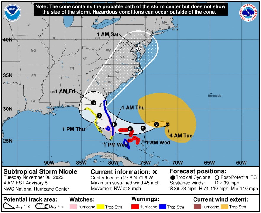
At 06:00 UTC on November 8, the center of Subtropical Storm “Nicole” was located about 665 km (415 miles) ENE of the Northwestern Bahamas, according to the National Hurricane Center (NHC).2
The system had maximum sustained winds of 75 km/h (45 mph) and a minimum central pressure of 998 hPa.
Nicole was moving NE at 11 km/h (7 mph).
A turn toward the west or west-southwest is forecast to begin today, and that motion should continue through early Thursday, November 10.
On the forecast track, the center of Nicole will approach the northwestern Bahamas today and tonight, move near or over those islands on Wednesday, November 9 and approach the east coast of Florida Wednesday night (LT).
Nicole is forecast to be at or near hurricane intensity by Wednesday or Wednesday night while it is moving near or over the northwestern Bahamas.
A Tropical Storm Warning is in effect for Andros Island, New Providence, and Eleuthera in the northwestern Bahamas; Hallandale Beach, Florida to Altamaha Sound, Georgia; Lake Okeechobee.
A Storm Surge Warning is in effect for North Palm Beach, Florida to Altamaha Sound Georgia; Mouth of the St. Johns River to Georgetown, Florida.
A Hurricane Watch is in effect for Hallandale Beach to the Volusia/Brevard County Line, Florida; Lake Okeechobee.
A Storm Surge Watch is in effect for areas south of North Palm Beach to Hallandale Beach, Florida.
A Tropical Storm Watch is in effect for areas South of Hallandale Beach to the north of Ocean Reef, Florida.
Hurricane conditions are expected in the northwest Bahamas within the hurricane warning area by early Wednesday, with tropical storm conditions expected elsewhere in the northwest Bahamas by tonight. Hurricane conditions are possible within the watch area in Florida by Wednesday night with tropical storm conditions possible by tonight or early Wednesday.
The combination of a dangerous storm surge and the tide will cause normally dry areas near the coast to be flooded by rising waters moving inland from the shoreline.
The water could reach the following heights above ground somewhere in the indicated areas if the peak surge occurs at the time of high tide:
- North Palm Beach to Altamaha Sound including the St. Johns River to the Fuller Warren Bridge: 0.9 – 1.5 m (3 to 5 feet)
- St. Johns River south of the Fuller Warren Bridge to Georgetown: 0.6 – 1.2 m (2 to 4 feet)
- Hallandale Beach to North Palm Beach: 0.6 – 1.2 m (2 to 4 feet)
- North of Ocean Reef to Hallandale Beach including Biscayne Bay: 0.3 – 0.6 m (1 to 2 feet)
Storm surge could raise water levels by as much as 1.2 – 1.8 m (4 to 6 feet) above normal tide levels along the immediate coast of the northwestern Bahamas in areas of onshore winds.
The deepest water will occur along the immediate coast near and to the north of the landfall location, where the surge will be accompanied by large and destructive waves. Surge-related flooding depends on the relative timing of the surge and the tidal cycle, and can vary greatly over short distances.
Nicole is expected to produce the following rainfall amounts through Thursday:
- Northwest Bahamas, central and northern portions of the Florida Peninsula: 75 – 125 mm (3 to 5 inches) with local maxima of 175 mm (7 inches)
- Southeast Florida and Southeast Georgia: 25 – 75 mm (1 to 3 inches) with local maxima of 100 mm (5 inches)
Heavy rainfall from this system will spread north farther up the Eastern Seaboard late this week into this weekend.
Large swells generated by Nicole will affect the northwest Bahamas, the east coast of Florida, and much of the southeastern United States coast during the next several days. These swells are likely to cause life-threatening surf and rip current conditions.
References:
1 Subtropical Storm Nicole Discussion Number 5 – NWS National Hurricane Center Miami FL – 400 AM EST Tue Nov 08 2022
2 Subtropical Storm Nicole Intermediate Advisory Number 4A – NWS National Hurricane Center Miami FL – AM EST Tue Nov 08 2022
I'm a dedicated researcher, journalist, and editor at The Watchers. With over 20 years of experience in the media industry, I specialize in hard science news, focusing on extreme weather, seismic and volcanic activity, space weather, and astronomy, including near-Earth objects and planetary defense strategies. You can reach me at teo /at/ watchers.news.
Commenting rules and guidelines
We value the thoughts and opinions of our readers and welcome healthy discussions on our website. In order to maintain a respectful and positive community, we ask that all commenters follow these rules.