
Grímsvötn volcano Aviation Color Code raised to Orange, Iceland
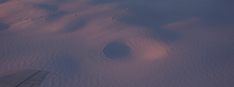
Image credit: IMO/Njál Fannar Reynisson
The Icelandic Met Office (IMO) has raised to Aviation Color Code for Grímsvötn volcano from Yellow to Orange on December 6, one day after the glacial flood from Grímsvötn reached its peak discharge. By definition, the Aviation Color Code is updated to Orange when a volcano shows increased activity and there is an increasing probability of an eruption.
The seismic activity at Grímsvötn has been increasing above the normal level over the last couple of days. A magnitude 2.3 earthquake was recorded near the volcano on December 6 followed at 06:10 UTC by a shallow M3.6 at the eastern summit caldera rim and several aftershocks of magnitude 1.1
This seismic activity is possibly occurring due to the decreased pressure above the volcano since the floodwater left Grímsvötn sub-glacial lake.
According to a GPS meter from the Meteorological Office in Grímsvötn, the ice cap has sunk about 77 m (252 feet) since subsidence started on November 24. The subsidence has slowed down a lot and the glacial flood has decreased, so it can be concluded that the lakes have mostly emptied.
According to flow measurements made between 16:00 and 18:00 UTC on December 5, the flow in Gígjukvísl was 2 310 m3/s (81 000 ft3/s). Between 09:30 and 12:30 on December 6, the flow was was 1 100 m3/s (39 200 ft3/s) and has therefore decreased significantly.
No volcanic tremor has been detected and no increase/changes in geochemical emissions at the volcano are measured, IMO said.
According to calculations from the Institute of Earth Sciences at the University of Iceland, at least 0.8 km3 (0.2 mi3) of water has drained from the sub-glacial lake. Due to this elevated seismic activity, the IMO has decided to raise the Aviation Color Code from Grímsvötn volcano from Yellow to Orange.
There are examples of eruptions in Grímsvötn after water flows from there.
“The last time this happened was in 2004 and before that in 1934 and 1922. In 2004, traces of the start of the eruption were seen on October 28 and the eruption began about three days later, or at the end of the day on November 1,” IMO said.
In the days before, the earthquake in Grímsvötn was a sign that an eruption was imminent.
The last eruption in Grímsvötn took place in 2011, but this time it had run out of Grímsvötn just over six months before. Since 2011 it has run a total of 6 times from Grímsvötn without an eruption.
The eruption has taken place every five to ten years from Grímsvötn, and scientists agree that measurements show that conditions are such that Grímsvötn is ready to erupt.
Update
The Aviation Color Code was lowered back to Yellow on December 7 as earthquakes decreased to normal values.
“When the seismicity increased we needed to react as it could have been a typical precursor of a volcanic eruption,” IMO’s earthquake hazards coordinator Kristín Jónsdóttir said.
“We need to react to any relevant changes in the volcano activity. In this case, it was likely that an eruption would have been triggered by the flood, and sometimes the time between the two events is not that long so we needed to be ready. This scenario, that a flood will trigger an eruption is becoming less likely as time passes.”
Geological summary
Grímsvötn, Iceland’s most frequently active volcano in historical time, lies largely beneath the vast Vatnajökull icecap. The caldera lake is covered by a 200 m (650 feet) ice shelf, and only the southern rim of the 6 x 8 km (3.7 x 5 miles) caldera is exposed.
The geothermal area in the caldera causes frequent jökulhlaups (glacier outburst floods) when melting raises the water level high enough to lift its ice dam.
Long NE-SW-trending fissure systems extend from the central volcano. The most prominent of these is the noted Laki (Skaftar) fissure, which extends to the SW and produced the world’s largest known historical lava flow during an eruption in 1783.
The 15 km3 (3.6 mi3) basaltic Laki lavas erupted over a 7-month period from a 27 km (16.7 miles) long fissure system. Extensive crop damage and livestock losses caused a severe famine that resulted in the loss of one-fifth of the population of Iceland.2
References:
1 Icesheet in Grímsvötn subsiding – IMO
2 Grímsvötn – Geological summary – GVP
I'm a dedicated researcher, journalist, and editor at The Watchers. With over 20 years of experience in the media industry, I specialize in hard science news, focusing on extreme weather, seismic and volcanic activity, space weather, and astronomy, including near-Earth objects and planetary defense strategies. You can reach me at teo /at/ watchers.news.
Commenting rules and guidelines
We value the thoughts and opinions of our readers and welcome healthy discussions on our website. In order to maintain a respectful and positive community, we ask that all commenters follow these rules.