
Tropical Storm “Nicholas” to make landfall in Texas, flash flooding, dangerous storm surge and gusty winds expected
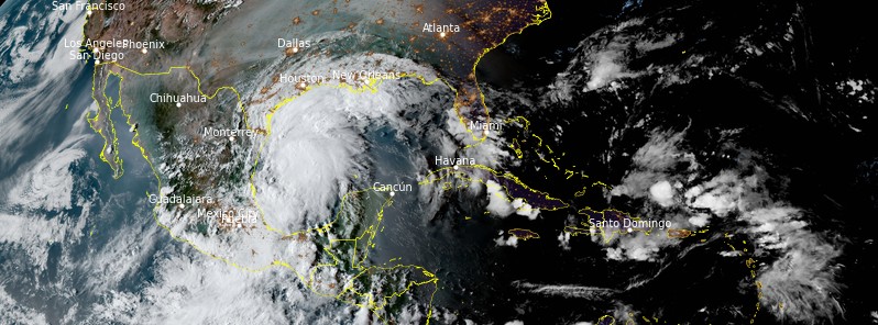
Featured image: Tropical Storm "Nicholas" at 22:50 UTC on September 13, 2021. Credit: NOAA/GOES-East, RAMMB/CIRA, TW
Tropical Storm "Nicholas" formed in the Gulf of Mexico at 15:00 UTC on September 12, 2021, as the 14th named storm of the 2021 Atlantic hurricane season. At the time, its center was located about 205 km (130 miles) NE of Veracruz, Mexico.
- Heavy rainfall will impact portions of the Texas and Louisiana coasts through the middle of the week. Significant rainfall amounts are possible, potentially resulting in areas of considerable flash and urban flooding, especially in highly urbanized metropolitan areas. Isolated minor to moderate river flooding is also expected.1
- There is the danger of life-threatening storm surge inundation along the coast of Texas from Port Aransas to San Luis Pass. Residents in these areas should follow any advice given by local officials.
- Nicholas is forecast to approach the middle Texas coast as a strong tropical storm today, and could be near hurricane intensity at landfall. Tropical storm conditions are expected along portions of the middle Texas coast beginning by this afternoon (LT), with hurricane conditions possible from Port Aransas to Freeport this afternoon and tonight.
- Tropical storm conditions are expected along portions of the northeastern coast of Mexico and the coast of south Texas during the next few hours.
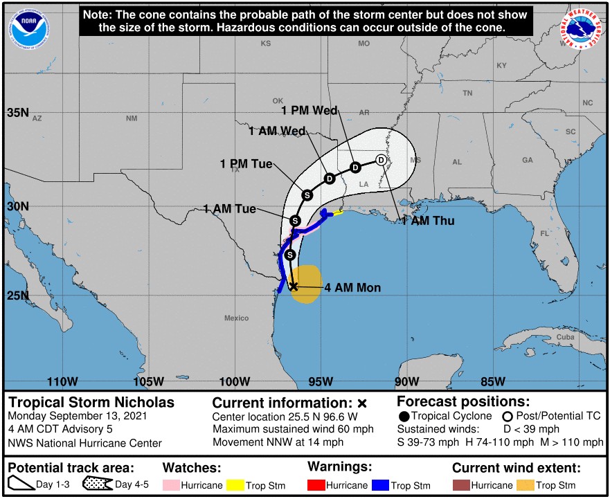
At 09:00 UTC on September 13, the center of Tropical Storm "Nicholas" was located 75 km (45 miles) SE of the mouth of the Rio Grande and 325 km (200 miles) S of Port O'Connor, Texas.
The storm had maximum sustained winds of 95 km/h (60 mph), minimum central pressure of 1 001 hPa, and was moving NNW at 22 km/h (14 mph).2
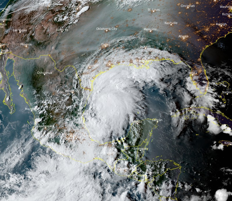
Tropical Storm "Nicholas" at 22:50 UTC on September 13, 2021. Credit: NOAA/GOES-East, RAMMB/CIRA, TW
Strengthening is forecast today, and Nicholas could reach the northwest Gulf coast as a hurricane.
Weakening is anticipated on Tuesday and Wednesday, September 14 and 15 over land.
A Storm Surge Warning is in effect for:
- Port Aransas to San Luis Pass, Texas
- Aransas Bay, San Antonio Bay, and Matagorda Bay
A Hurricane Watch is in effect for:
- Port Aransas to Freeport, Texas
A Tropical Storm Warning is in effect for:
- Mouth of the Rio Grande to High Island, Texas
- Barra el Mezquital to the U.S./Mexico border
A Storm Surge Watch is in effect for:
- Mouth of the Rio Grande to Port Aransas, Texas
- San Luis Pass Texas to Rutherford Beach Louisiana, including Galveston Bay
- Baffin Bay and Corpus Christi Bay
A Tropical Storm Watch is in effect for:
- East of High Island, Texas to Sabine Pass
Nicholas is expected to turn northward later today and NNE on Tuesday, September 14.
On the forecast track, the center of Nicholas will pass near or just offshore the coasts of northeastern Mexico and south Texas this morning, and move onshore along the coast of south or central Texas Monday afternoon or evening.
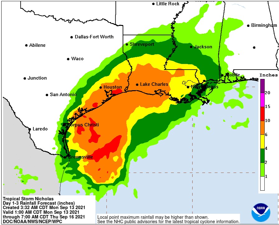
Nicholas is expected to produce storm total rainfall of 200 – 400 mm (8 to 16 inches), with isolated maximum amounts of 500 mm (20 inches), across portions of the middle and upper Texas coastal areas through the middle of the week.
Across the rest of coastal Texas into southwest Louisiana rainfall of 125 to 250 mm (5 to 10 inches) is expected. This rainfall may produce areas of considerable flash and urban flooding, especially in highly urbanized metropolitan areas. Additionally, there is the potential for isolated minor to moderate river flooding.
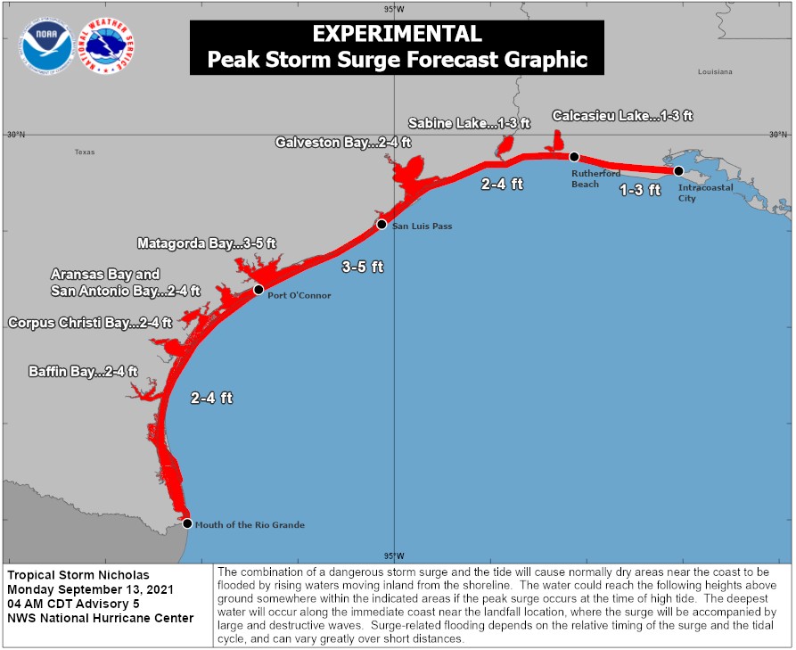
The combination of a dangerous storm surge and the tide will cause normally dry areas near the coast to be flooded by rising waters moving inland from the shoreline.
The water could reach the following heights above ground somewhere in the indicated areas if the peak surge occurs at the time of high tide:
- Port O'Connor to San Luis Pass TX including Matagorda Bay: 0.9 – 1.5 m (3 – 5 feet),
- San Luis Pass, TX to Rutherford Beach, LA including Galveston Bay: 0.6 – 1.2 m (2 – 4 feet),
- Mouth of the Rio Grande to Port O'Connor, TX: 0.6 – 1.2 m (2 – 4 feet),
- Baffin Bay, Corpus Christi Bay, Aransas Bay and San Antonio Bay: 0.6 – 1.2 m (2 – 4 feet),
- Rutherford Beach, LA to Intracoastal City, LA: 0.3 – 0.9 m (1 – 3 feet),
- Sabine Lake and Calcasieu Lake: 0.3 – 0.9 m (1 – 3 feet).
The deepest water will occur along the immediate coast in areas of onshore winds, where the surge will be accompanied by large and dangerous waves. Surge-related flooding depends on the relative timing of the surge and the tidal cycle, and can vary greatly over short distances.
Tropical storm conditions are expected to first reach the coast within the warning area in northeastern Mexico and southern Texas this morning, making outside preparations difficult or dangerous. These conditions will spread northward within the warning area through tonight.
Hurricane conditions are possible in the Hurricane Watch area as early as this afternoon. Tropical storm conditions are possible within the watch area by tonight or early Tuesday.
A tornado or two will be possible today into tonight across the Texas coast.
Swells generated by Nicholas will continue affecting portions of the northwest Gulf coast through Tuesday.
These swells are likely to cause life-threatening surf and rip current conditions.
References:
1 Tropical Storm Nicholas Discussion Number 5 – NWS National Hurricane Center Miami FL AL142021 – 400 AM CDT Mon Sep 13 2021
2 BULLETIN – Tropical Storm Nicholas Advisory Number 5 – NWS National Hurricane Center Miami FL – AL142021 400 AM CDT Mon Sep 13 2021
I'm a dedicated researcher, journalist, and editor at The Watchers. With over 20 years of experience in the media industry, I specialize in hard science news, focusing on extreme weather, seismic and volcanic activity, space weather, and astronomy, including near-Earth objects and planetary defense strategies. You can reach me at teo /at/ watchers.news.
Commenting rules and guidelines
We value the thoughts and opinions of our readers and welcome healthy discussions on our website. In order to maintain a respectful and positive community, we ask that all commenters follow these rules.