
Idalia strengthening, forecast to impact Florida as Category 2 or 3 hurricane
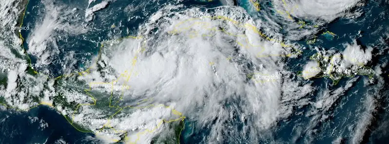
Featured image: Tropical Storm "Idalia" at 21:50 UTC on August 27, 2023. Credit: NOAA/GOES-East, RAMMB/CIRA, The Watchers
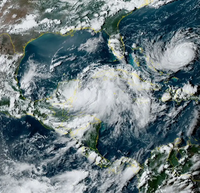
Tropical Storm “Idalia” formed in the Caribbean Sea on Sunday, August 27, 2023, as the 10th named storm of the 2023 Atlantic hurricane season. The system is still strengthening and is expected to make landfall in Florida as a Category 2 or 3 hurricane on Wednesday, August 30.
- Idalia is forecast to become a hurricane by the time it reaches the southeastern Gulf of Mexico, and it could be near or at major hurricane strength when it reaches the Gulf coast of Florida. The risk continues to increase for a life-threatening storm surge and hurricane-force winds along portions of the west coast of Florida and the Florida Panhandle beginning as early as Tuesday. Storm surge and hurricane watches are in effect for portions of the west coast of Florida and the coast of the Florida Panhandle, and residents in these areas should monitor updates to the NHC forecast and follow any advice given by local officials.
- Scattered flash and urban flooding is expected across portions of the west coast of Florida, the Florida Panhandle, and southern Georgia late Tuesday night through Wednesday. Heavy rainfall may lead to flash flooding across portions of the Carolinas Wednesday into Thursday.
- Hurricane-force winds are expected across portions of far western Cuba late Monday. Heavy rainfall is expected across portions of eastern Yucatan and western Cuba and may produce areas of flash and urban flooding as well as landslides across western Cuba.
At 06:00 UTC on August 28, the center of Tropical Storm “Idalia” was located about 245 km (150 miles) S of the western tip of Cuba. It had maximum sustained winds of 95 km/h (60 mph). At the time, Idalia was nearly a stationary system with a minimum central pressure of 990 hPa.
A motion toward the north-northeast and north is expected to begin later today, bringing the center of Idalia over the extreme southeastern Gulf of Mexico by tonight (LT). Idalia will then continue on a northward or north-northeastward path over the eastern Gulf of Mexico on Tuesday and reach the Gulf coast of Florida on Wednesday.
Strengthening is forecast, and Idalia is expected to become a hurricane later today. The system is likely to be near or at major hurricane intensity when it reaches the Gulf Coast of Florida.
On August 26, Florida Governor Ron DeSantis declared a state of emergency for 33 Gulf Coast counties in advance of the storm. The next day, a hurricane watch was issued for much of the west coast of Florida.
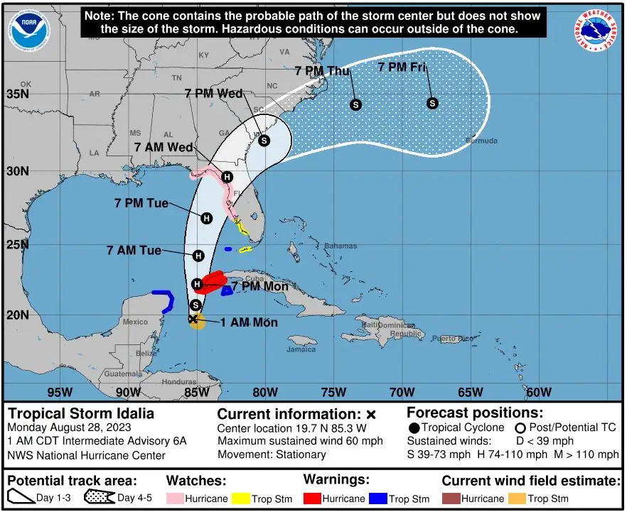
As of 06:00 UTC on August 28, a Hurricane Warning is in effect for Pinar del Rio, Cuba. A Tropical Storm Warning is in effect for the Yucatan Peninsula from Tulum to Rio Lagartos, including Cozumel, Isle of Youth, Cuba, and Dry Tortugas, Florida.
A Storm Surge Watch is in effect for Chokoloskee to Indian Pass, Florida, including Tampa Bay.
A Hurricane Watch is in effect for Englewood to Indian Pass Florida, including Tampa Bay and a Tropical Storm Watch is in effect for areas South of Englewood to Chokoloskee, Florida, and Lower Florida Keys west of the west end of the Seven Mile Bridge.
Hurricane conditions are expected within the hurricane warning area in western Cuba by late today. Winds are expected to first reach tropical storm strength by this morning, making outside preparations difficult or dangerous. Preparations to protect life and property should be rushed to completion.
Tropical storm conditions are expected over portions of the tropical storm warning area over the Yucatan Peninsula and the Isle of Youth in Cuba through today
Hurricane conditions are possible within the hurricane watch area by late Tuesday or Wednesday, with tropical storm conditions possible by Tuesday.
Tropical storm conditions are possible in the Dry Tortugas beginning late today and within the tropical storm watch area along the Florida Gulf coast on Tuesday.
The combination of a dangerous storm surge and the tide will cause normally dry areas near the coast to be flooded by rising waters moving inland from the shoreline.
The water could reach the following heights above ground somewhere in the indicated areas if the peak surge occurs at the time of high tide:
Aucilla River, FL to Chassahowitzka, FL: 2.1 – 3.4 m (7 – 11 feet)
Chassahowitzka, FL to Anclote River, FL: 1.8 – 2.7 m (6 – 9 feet)
Ochlockonee River, FL to Aucilla River, FL: 1.2 – 2.1 m (4 – 7 feet)
Anclote River, FL to Middle of Longboat Key, FL: 1.2 – 2.1 m (4 – 7 feet)
Tampa Bay: 1.2 – 2.1 m (4 – 7 feet)
Middle of Longboat Key, FL to Englewood, FL: 0.9 – 1.5 m (3- 5 feet)
Englewood, FL to Chokoloskee, FL: 0.6 – 1.2 m (2 – 4 feet)
Charlotte Harbor… 0.6 – 1.2 m (2 – 4 feet)
Indian Pass, FL to Ochlockonee River, FL: 0.6 – 1.2 m (2 – 4 feet)
Chokoloskee, FL to East Cape Sable, FL: 0.3 – 0.9 m (1 – 3 feet)
Florida Keys: 0.3 – 0.6 m (1 – 2 feet)
The deepest water will occur along the immediate coast in areas of onshore winds, where the surge will be accompanied by large and dangerous waves. Surge-related flooding depends on the relative timing of the surge and the tidal cycle and can vary greatly over short distances.
Storm surge will raise water levels by as much as 1.2 – 1.8 m (4 to 6 feet) above normal tide levels along the southern coast of Pinar del Rio, Cuba. Near the coast, the surge will be accompanied by large waves.
Idalia is expected to produce the following rainfall amounts:
Portions of the eastern Yucatan: 25 – 76 mm (1 to 3 inches), with isolated higher totals of 127 mm (5 inches). Western Cuba: 76 – 152 mm (3 to 6 inches), with isolated higher totals of 254 mm (10 inches). Portions of the west coast of Florida, the Florida Panhandle, and southern Georgia (from Tuesday into Wednesday): 76 – 152 mm (3 to 6 inches), with isolated higher totals of 254 mm (10 inches).
Heavy rainfall is also expected across portions of the Carolinas by Wednesday into Thursday.
Heavy rainfall from Tropical Storm “Idalia” is expected across portions of eastern Yucatan and western Cuba and may produce areas of flash and urban flooding as well as landslides across western Cuba.
Scattered flash and urban flooding is expected across portions of the west coast of Florida, the Florida Panhandle, and southern Georgia late Tuesday night through Wednesday. Heavy rainfall may lead to flash flooding across portions of the Carolinas Wednesday into Thursday.
References:
1 Tropical Storm Idalia – Intermediate Advisory Number 6A – NWS National Hurricane Center Miami FL AL102023 – 100 AM CDT Mon Aug 28 2023
The Watchers team and our contributors bring the latest on extreme weather, earthquakes, volcanic eruptions, space weather, and all things science. We're all about making sense of the natural world and keeping you informed on what’s happening. Got a tip or a question? Hit us up using the form at newstips!
Commenting rules and guidelines
We value the thoughts and opinions of our readers and welcome healthy discussions on our website. In order to maintain a respectful and positive community, we ask that all commenters follow these rules.