
Hurricane “Idalia” threatens parts of Florida with catastrophic storm surge, U.S.
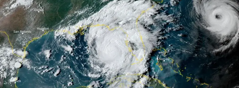
Featured image: Hurricane "Idalia" at 22:20 UTC on August 29, 2023. Credit: NOAA/GOES-East, RAMMB/CIRA, The Watchers
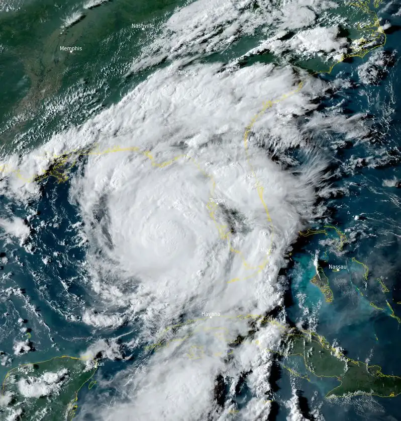
Idalia has strengthened into a Category 2 hurricane and is expected to become a major hurricane tonight before it reaches the Big Bend coast of Florida on August 30, 2023. It is likely to still be a hurricane while moving across southern Georgia, and possibly when it reaches the coast of Georgia or southern South Carolina on Wednesday.
- Catastrophic impacts from storm surge inundation of 3 to 4.5 m (10 to 15 feet) above ground level and destructive waves are expected somewhere between Aucilla River and Yankeetown, Florida. Life-threatening storm surge inundation is likely elsewhere along portions of the Florida Gulf Coast where a Storm Surge Warning is in effect. Residents in these areas should follow any advice given by local officials.
- There is the potential for destructive life-threatening winds where the core of Idalia moves onshore in the Big Bend region of Florida, with hurricane conditions expected elsewhere in portions of the Hurricane Warning area along the Florida Gulf Coast. Strong winds will also spread inland across portions of northern Florida and southern Georgia near the track of the center of Idalia where Hurricane Warnings are in effect. Residents in these areas should be prepared for long-duration power outages. Damaging hurricane-force winds are possible in portions of eastern Georgia and southeastern South Carolina where Hurricane Watches are in effect.
- Areas of flash, urban, and moderate river flooding, with locally considerable impacts, are expected across the Florida Big Bend, central Georgia and South Carolina, through eastern North Carolina later tonight into Thursday.
As of 17:00 EDT (21:00 UTC) on August 29, 2023, the center of Hurricane “Idalia” was located approximately 310 km (195 miles) southwest of Tampa and about 480 km (300 miles) south of Tallahassee, Florida. The hurricane had maximum sustained winds of 155 km/h (100 mph) and was moving northward at a speed of 26 km/h (16 mph). The storm’s minimum central pressure has been recorded at 972 hPa.
Hurricane-force winds extend outward up to 35 km (25 miles) from the center and tropical-storm-force winds extend outward up to 260 km (160 miles).
A northward to north-northeastward motion is expected through tonight, with Idalia’s center forecast to reach the Big Bend coast of Florida on Wednesday morning (LT), August 30. After landfall, the center of Idalia is forecast to turn toward the northeast and east, moving near or along the coasts of Georgia, South Carolina, and North Carolina late Wednesday and Thursday.
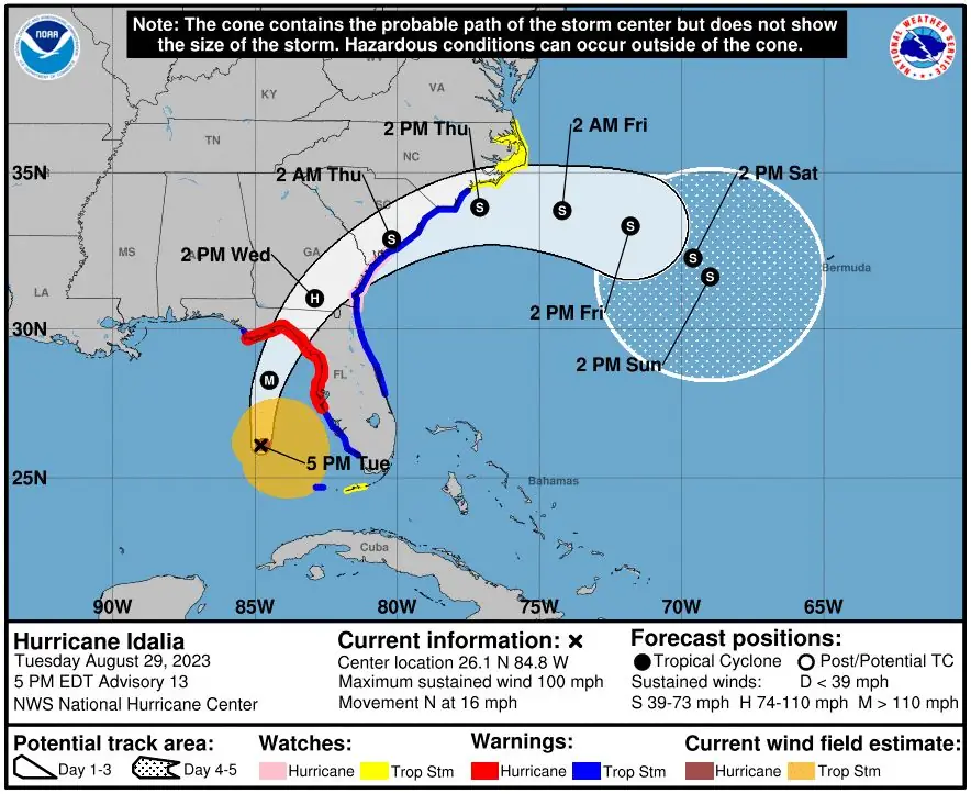
Additional strengthening is forecast, and Idalia is expected to become a major hurricane tonight before it reaches the Big Bend coast of Florida. Idalia is likely to still be a hurricane while moving across southern Georgia, and possibly when it reaches the coast of Georgia or southern South Carolina.
The combination of a dangerous storm surge and the tide will cause normally dry areas near the coast to be flooded by rising waters moving inland from the shoreline. The water could reach the following heights above ground somewhere in the indicated areas if the peak surge occurs at the time of high tide:
- Aucilla River, FL to Yankeetown, FL: 3.05 – 4.57 m (10 – 15 feet)
- Yankeetown to Chassahowitzka, FL: 2.13 – 3.35 m (7 – 11 feet)
- Ochlockonee River, FL to Aucilla River, FL: 2.13 – 3.35 m (7 – 11 feet)
- Chassahowitzka, FL to Anclote River, FL: 1.83 – 2.74 m (6 – 9 feet)
- Anclote River, FL to Middle of Longboat Key, FL: 1.22 – 1.83 m (4 – 6 feet)
- Tampa Bay: 1.22 – 1.83 m (4 – 6 feet)
- Carrabelle, FL to Ochlockonee River, FL: 1.22 – 2.13 m (4 – 7 feet)
- Middle of Longboat Key, FL to Englewood, FL: 0.91 – 1.52 m (3 – 5 feet)
- Englewood, FL to Bonita Beach, FL: 0.61 – 1.22 m (2 – 4 feet)
- Charlotte Harbor: 0.61 – 1.22 m (2 – 4 feet)
- Indian Pass, FL to Carrabelle, FL: 0.91 – 1.52 m (3 – 5 feet)
- Mouth of the St. Mary’s River to South Santee, SC: 0.61 – 1.22 m (2 – 4 feet)
- Beaufort Inlet to Drum Inlet, NC: 0.61 – 1.22 m (2 – 4 feet)
- Pamlico and Neuse Rivers: 0.61 – 1.22 m (2 – 4 feet)
- South of Bonita Beach to Chokoloskee, FL: 0.30 – 0.91 m (1 – 3 feet)
- South Santee, SC to Beaufort Inlet, NC: 0.30 – 0.91 m (1 – 3 feet)
- Drum Inlet to Duck, NC: 0.3 – 0.9 m (1 – 3 feet)
- Chokoloskee, FL to East Cape Sable, FL: 0.3 – 0.9 m (1 – 3 feet)
- Flagler/Volusia County Line, FL to Mouth of St. Mary’s River: 0.3 – 0.9 m (1 – 3 feet)
- Indian Pass to Mexico Beach: 0.3 to 0.9 m (1 to 3 feet)
- Florida Keys: 0.3 – 0.6 m (1 – 2 feet)
The deepest water will occur along the immediate coast in areas of onshore winds, where the surge will be accompanied by large and dangerous waves. Surge-related flooding depends on the relative timing of the surge and the tidal cycle, and can vary greatly over short distances.
Idalia is expected to produce the following rainfall amounts:
Western Cuba: 100 to 180 mm (4 to 7 inches), with isolated higher totals of 250 mm (10 inches).
Portions of the west coast of Florida, the Florida Panhandle, southeast Georgia, and the eastern Carolinas: 100 to 200 mm (4 to 8 inches) from Tuesday into Thursday. Isolated higher totals of 300 mm (12 inches) are possible, primarily near landfall in northern Florida.
This rainfall may lead to flash and urban flooding, and landslides across western Cuba.
Areas of flash and urban flooding, some of which may be locally significant, are expected across portions of the west coast of Florida, the Florida Panhandle, and southern Georgia Tuesday into Wednesday, spreading into portions of the eastern Carolinas Wednesday into Thursday.
Swells generated by Idalia are already affecting the southwestern coast of Florida and will spread northward and westward to the north-central Gulf coast through Wednesday. Swells affecting portions of the southern coast of Cuba will subside tonight. These swells are likely to cause life-threatening surf and rip current conditions. Please consult products from your local weather office.
A few tornadoes will be possible along the west central Florida coast through tonight. The tornado threat will also spread northward into the Florida Big Bend tonight, and toward southeast Georgia and the coastal Carolinas Wednesday.
This morning, Governor Ron DeSantis held a briefing about Hurricane “Idalia” at the State Emergency Operations Center. The storm prompted evacuation orders in 22 counties and the declaration of a state of emergency in 49 counties.
To offer accurate and up-to-date information during emergencies or disasters affecting Florida, the Florida Division of Emergency Management (FDEM) has introduced the State Assistance Information Line (SAIL), a toll-free hotline. Residents can call 1-800-342-3557 to access this resource for information.
References:
1 Hurricane Idalia Advisory Number 13 – Corrected NWS National Hurricane Center Miami FL AL102023 – 500 PM EDT Tue Aug 29 2023
2 Governor Ron DeSantis Issues Updates on Hurricane Idalia – Florida Government – August 29, 2023
I'm a dedicated researcher, journalist, and editor at The Watchers. With over 20 years of experience in the media industry, I specialize in hard science news, focusing on extreme weather, seismic and volcanic activity, space weather, and astronomy, including near-Earth objects and planetary defense strategies. You can reach me at teo /at/ watchers.news.
Commenting rules and guidelines
We value the thoughts and opinions of our readers and welcome healthy discussions on our website. In order to maintain a respectful and positive community, we ask that all commenters follow these rules.