
Category 3 Hurricane “Idalia” strikes Florida’s Big Bend with destructive winds and storm surge
Featured image: Hurricane "Idalia" at 20:30 UTC on August 30, 2023. Credit: NOAA/GOES, RAMMB/CIRA, The Watchers
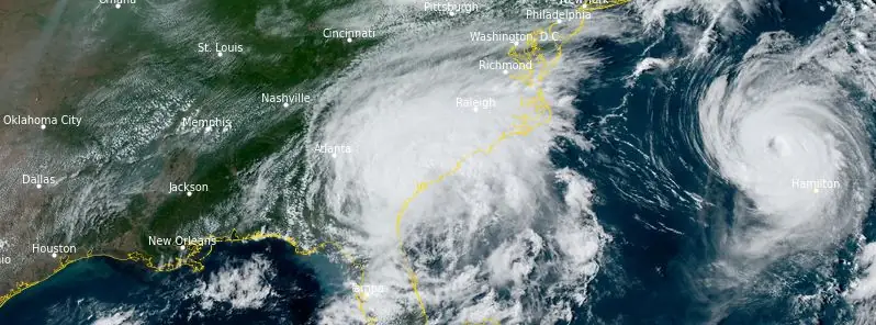
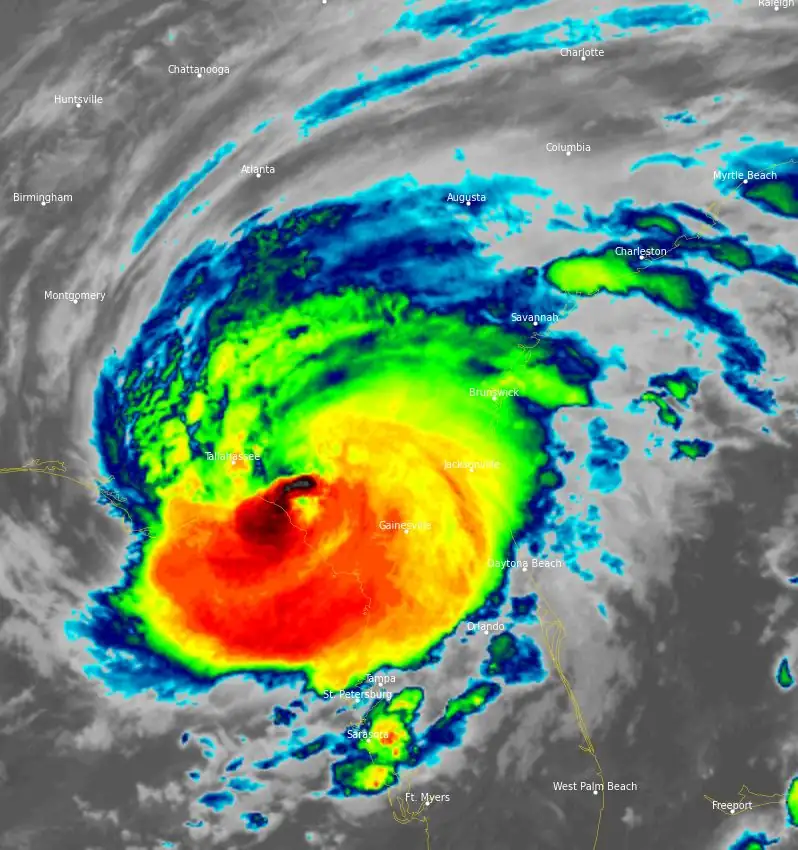
Hurricane “Idalia” intensified from Category 1 to Category 4 in just 24 hours and made landfall shortly before 08:00 EDT (12:00 UTC) on Wednesday, August 30, 2023, near Keaton Beach in Florida’s Big Bend. The hurricane officially hit as a Category 3 storm with winds reaching 200 km/h (125 mph).
Although Idalia reached category 4 intensity early this morning over the far northeastern Gulf of Mexico, Air Force Reserve Hurricane Hunter data just before landfall indicated that the peak winds had started to decrease and the minimum pressure had begun to rise. This was likely due to an eyewall replacement cycle and an increase in shear over the hurricane, NHC forecaster Berg noted.
Idalia made landfall near Keaton Beach, Florida, as a Category 3 hurricane around 11:45 UTC, and it has been weakening quickly since then over northern Florida.
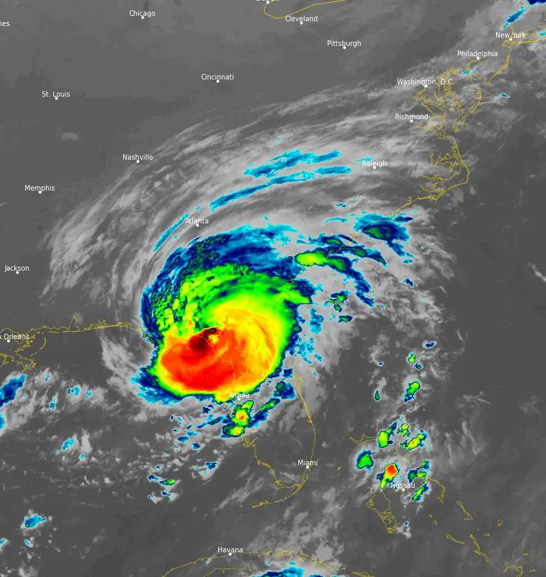
At 15:00 UTC, WSR-88D Doppler velocities suggested that the maximum winds weakened down to about 150 km/h (90 mph). Idalia was moving toward the north-northeast at 31 km/h (20 mph). It was located between a subtropical ridging near the Greater Antilles and a deep-layer trough over the eastern United States. This pattern is expected to cause Idalia to turn toward the northeast and then east during the next 36 hours, and the track guidance is very good agreement on the center moving near the coasts of Georgia, South Carolina, and North Carolina through Thursday, August 31.
“Model spread increases beyond 36 hours, although there is not as much uncertainty as yesterday. None of the models shows the circulation curving back toward the U.S. anymore, but the guidance is suggestive that Idalia will likely slow down as it approaches Bermuda on days 3 through 5. During that period, the NHC track forecast is a blend of the previous forecast with the current HCCA and TVCX consensus aids,” Berg said.
Relatively fast weakening is anticipated through the rest of the day. The intensity guidance is hovering right around the hurricane threshold at 12 hours, and the official forecast therefore conservatively shows a 75 km/h (85 mph) hurricane near the Georgia/South Carolina border this evening.
Idalia should become a tropical storm by tonight while moving near the coast of South Carolina. Beyond the next 36 hours, the guidance suggests that Idalia’s intensity is likely to hover between 85 – 93 km/h (50 – 55 mph) over the next 5 days.
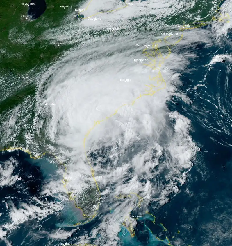
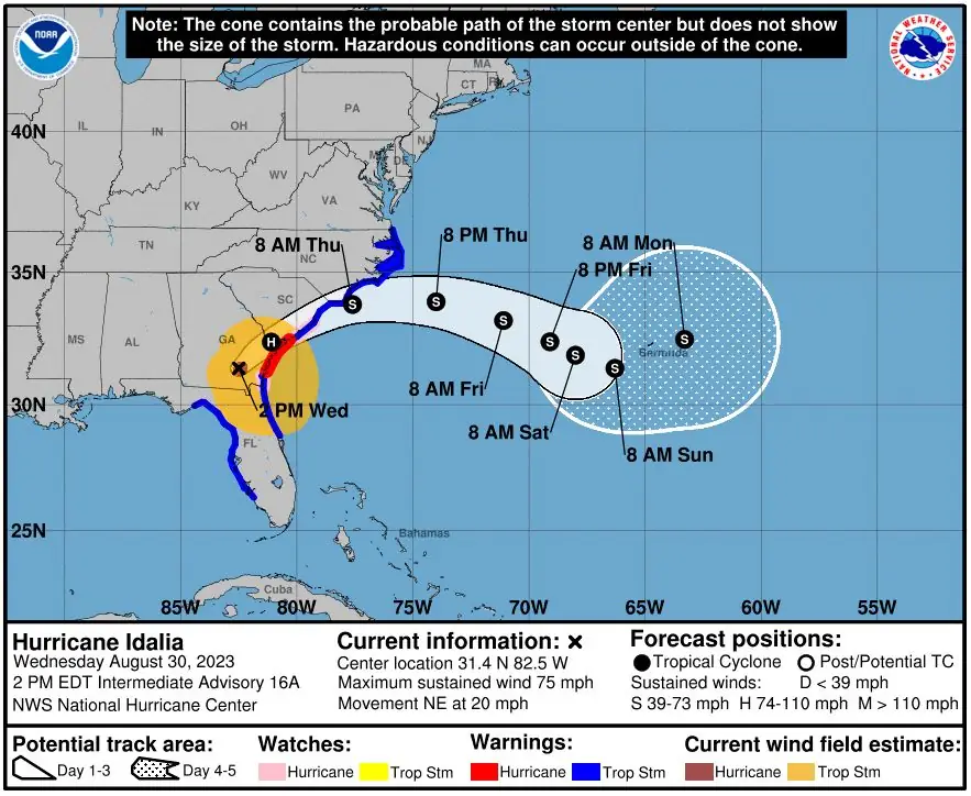
At 18:00 UTC on August 30, the center of Idalia was located about 20 km (12 miles) NNW of Waycross, Georgia, and about 160 km (100 miles) WSW of Savannah, Georgia.
It had maximum sustained winds of 120 km/h (75 km/h) and was moving NE at 31 km/h (20 mph). The minimum central pressure was 981 hPa.
Significant impacts from storm surge will continue along the Gulf coast of Florida within the Storm Surge Warning through this evening (LT, August 30). Dangerous storm surge is also expected along the southeastern U.S. coast within the Storm Surge Warning area tonight and Thursday. Residents in these areas should follow any advice given by local officials.
Damaging hurricane-force winds will occur where the core of Idalia moves across southern Georgia and southern South Carolina within the hurricane warning area through this evening. Residents in these areas should be prepared for long-duration power outages. Strong winds are also expected to spread northeastward across South Carolina and North Carolina through Thursday within the Tropical Storm Warning area.
Areas of flash, urban, and moderate river flooding, with considerable impacts, are expected from portions of North Florida through central Georgia and South Carolina, through eastern North Carolina into Thursday.
At 21:25 UTC, 460 000 customers, or about 1.15 million people, were without power, according to PowerOutage.
Two Florida men lost their lives in separate weather-related car accidents on Wednesday. The specifics of these incidents remain under investigation, but Florida Highway Patrol Sgt. Steve Gaskins has confirmed their unfortunate connection to the storm’s conditions.
According to Flight Aware, approximately 1 000 flights nationwide have been canceled and a further 2 000 faced delays. Most of these disruptions are concentrated in the Southeast, as airports in the region grapple with the storm’s repercussions, leading to significant travel inconveniences for passengers across the country.
References:
1 Tropical Storm Idalia – Advisory Number 17 – NWS National Hurricane Center Miami FL AL102023 – 500 PM EDT Wed Aug 30 2023
2 Hurricane Idalia – Discussion Number 16 Retransmitted – NWS National Hurricane Center Miami FL AL102023 – 1100 AM EDT Wed Aug 30 2023
I'm a dedicated researcher, journalist, and editor at The Watchers. With over 20 years of experience in the media industry, I specialize in hard science news, focusing on extreme weather, seismic and volcanic activity, space weather, and astronomy, including near-Earth objects and planetary defense strategies. You can reach me at teo /at/ watchers.news.
Commenting rules and guidelines
We value the thoughts and opinions of our readers and welcome healthy discussions on our website. In order to maintain a respectful and positive community, we ask that all commenters follow these rules.