
Hurricane “Larry” forecast to move over SE Newfoundland, Canada
Featured image: Hurricane "Olaf" at 10:40 UTC on September 10, 2021. Credit: NOAA/GOES-East, RAMMB/CIRA, TW
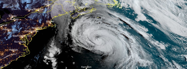
Hurricane "Larry" is expected to pass well southeast of Nova Scotia today, September 10, 2021, and then move over southeastern Newfoundland tonight, bringing hurricane-force winds, dangerous storm surge, and heavy rainfall.
- Larry is forecast to move over portions of southeastern Newfoundland tonight as it undergoes transition to a hurricane-force post-tropical cyclone. Hurricane conditions, a dangerous storm surge, and heavy rainfall are expected in portions of southeastern Newfoundland where a Hurricane Warning in effect.1
- Large swells generated by Larry will continue to affect the Bahamas, Bermuda, and the east coast of the United States and Atlantic Canada through Saturday. These swells will cause life-threatening surf and rip current conditions, and beachgoers and other interests along these coasts are urged to follow the guidance of lifeguards and local officials.
- A Hurricane Warning is in effect for southeastern Newfoundland from Arnold's Cove to Jones Harbour.
- A Tropical Storm Warning is in effect for southeastern Newfoundland from Francois to west of Arnold's Cove; and from north of Jones Harbor to Fogo Island.
At 09:00 UTC on September 10, the center of Hurricane "Larry" was located about 660 km (410 miles) NNE of Bermuda and 1 230 km (765 miles) SW of Cape Race, Newfoundland, Canada. The storm had maximum sustained winds of 140 km/h (85 mph) and minimum central pressure of 968 hPa.2
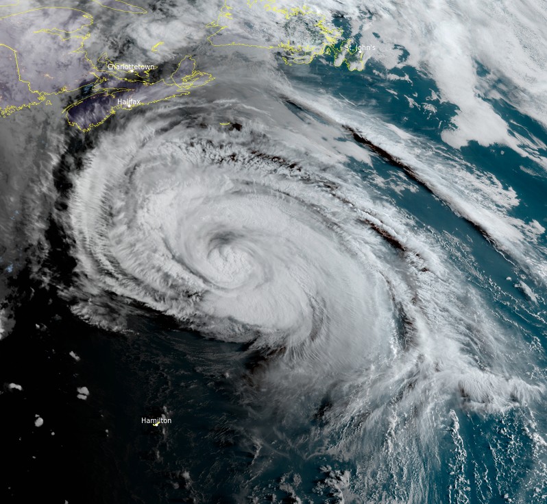
Hurricane "Larry" at 10:40 UTC on September 10, 2021. Credit: NOAA/GOES-East, RAMMB/CIRA, TW
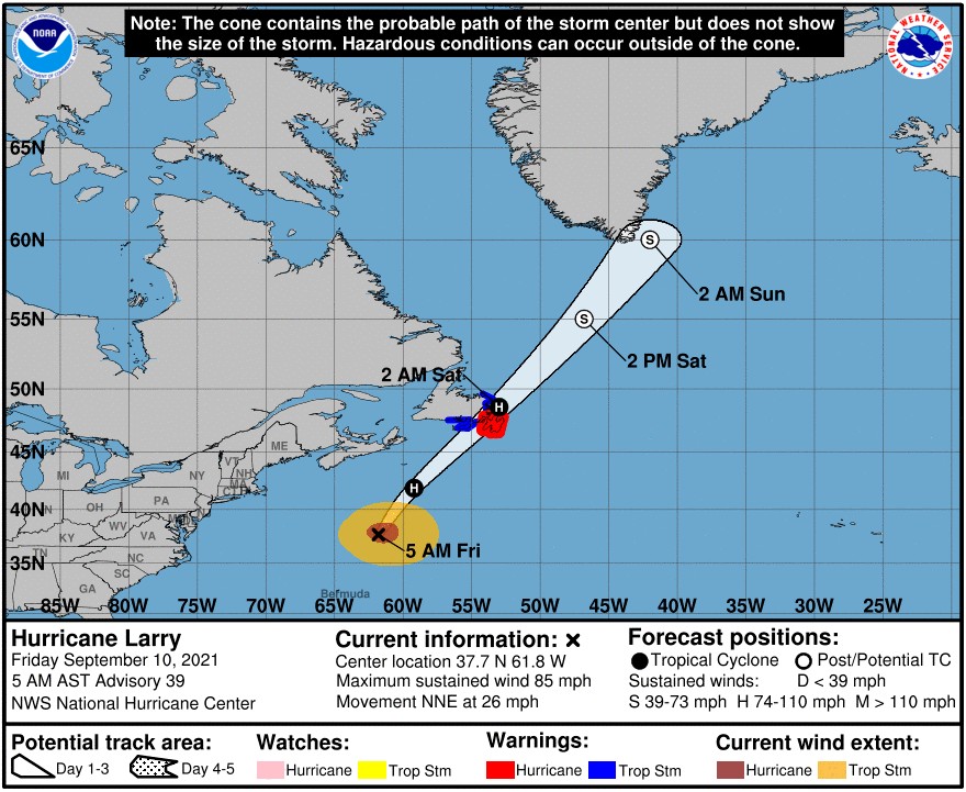
Larry is moving toward the north-northeast at a speed near 43 km/h (26 mph).
A turn to the northeast with a further increase in forward speed is expected today.
On the forecast track, the center of Larry will pass well southeast of Nova Scotia today, and move over southeastern Newfoundland tonight, NHC said.
Gradual weakening is forecast during the next day or so, but Larry is expected to remain a hurricane until it passes Newfoundland.
A dangerous storm surge is expected to produce coastal flooding within the warning areas in southeastern Newfoundland.
Swells generated by Larry will continue to affect the Bahamas today.
Significant swells from Larry will continue affecting Bermuda, the east coast of the United States, and Atlantic Canada through Saturday. These swells are likely to cause life-threatening surf and rip current conditions.
Heavy rains from Larry will move quickly across eastern Newfoundland tonight, producing 25 – 50 mm (1 to 2 inches) of rain.
Larry should become an extratropical cyclone on Saturday, and is now forecast to be absorbed by a larger extratropical low near Greenland by the end of the weekend.
Hurricane-force winds extend outward up to 150 km (90 miles) from the center and tropical-storm-force winds extend outward up to 390 km (240 miles).
References:
1 Hurricane Larry Discussion Number 39 – NWS National Hurricane Center Miami FL AL122021 – 500 AM AST Fri Sep 10 2021
2 BULLETIN – Hurricane Larry Advisory Number 39 – NWS National Hurricane Center Miami FL AL122021 – 500 AM AST Fri Sep 10 2021
I'm a dedicated researcher, journalist, and editor at The Watchers. With over 20 years of experience in the media industry, I specialize in hard science news, focusing on extreme weather, seismic and volcanic activity, space weather, and astronomy, including near-Earth objects and planetary defense strategies. You can reach me at teo /at/ watchers.news.
Commenting rules and guidelines
We value the thoughts and opinions of our readers and welcome healthy discussions on our website. In order to maintain a respectful and positive community, we ask that all commenters follow these rules.