
Very strong and shallow M7.0 earthquake hits near Acapulco, Mexico
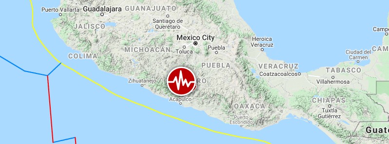
Image credit: TW/SAM, Google
A very strong and shallow earthquake registered by the USGS as M7.0 hit near Acapulco, Mexico at 01:47 UTC on September 8, 2021 (20:47 CDT, September 7). The agency is reporting a depth of 20 km (12.4 miles). EMSC is reporting M7.0 at a depth of 10 km (6.2 miles), National Seismic Service of Mexico M7.1.
The epicenter was located 2 km (1.2 miles) SSE of Kilometro 30 (population 6 301), 21 km (13 miles) NE of Acapulco de Juares (population 673479) and 67 km (43 miles) SSW of Chilpancingo (population 187 251), Guerrero, Mexico.
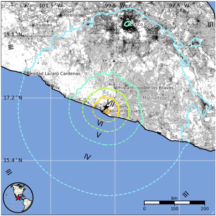
There are about 920 000 people living within 100 km (62 miles).
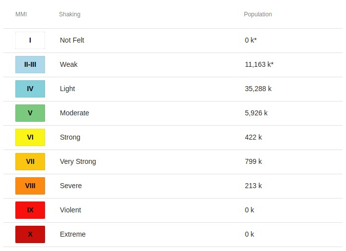
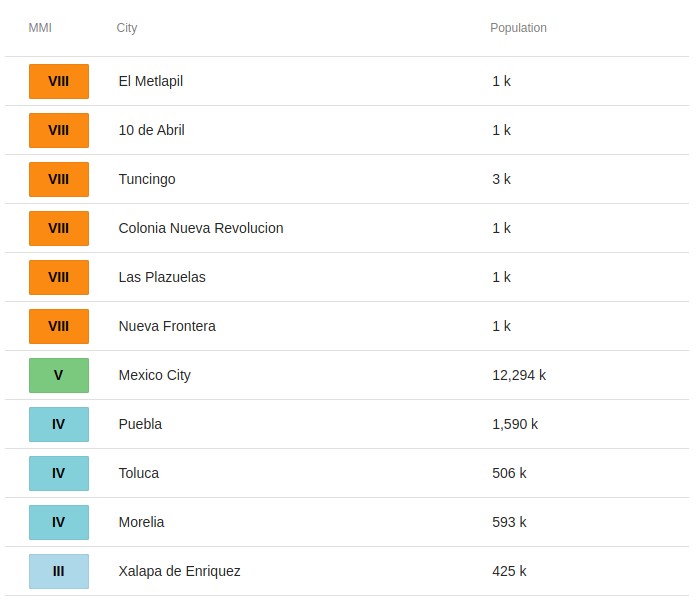
213 000 people are estimated to have felt severe shaking, 799 000 very strong, 422 000 strong and 35 288 light. Moderate shaking was felt in Mexico City.
The USGS issued an Orange alert for shaking-related, indicating significant casualties are likely.
A Red alert was issued for economic losses – extensive damage is probable and the disaster is likely widespread. Estimated economic losses are less than 1% of GDP of Mexico. Past events with this alert level have required a national or international level response.
Overall, the population in this region resides in structures that are a mix of vulnerable and earthquake-resistant construction. The predominant vulnerable building types are mud wall and adobe block with concrete bond beam construction.
Recent earthquakes in this area have caused secondary hazards such as tsunamis and landslides that might have contributed to losses.
The Civil Protection of Guerrero State reports evacuated people in Chilpancingo City.
A 50 cm (20 inches) high tsunami wave was recorded over the coast of Acapulco City.
The quake damaged hospitals, homes, shops and hotels, and caused power outages.
One person was killed by a falling post in the town of Coyuca de Benitez near Acapulco.
The government offices in Guerrero suffered structural damage and broken windows, along with other public and private buildings, the state's governor, Hector Astudillo, said.
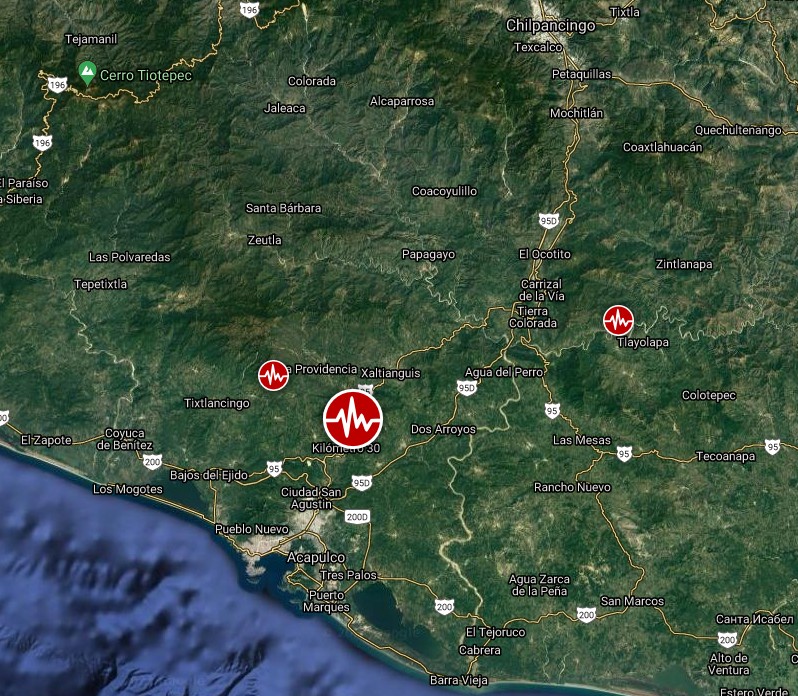
Image credit: TW/SAM, Google
Landslides and liquefaction triggered by this event are estimated to be limited in severity and/or spatial extent, according to the USGS. The number of people living near areas that could have produced landslides and liquefaction in this earthquake is significant.
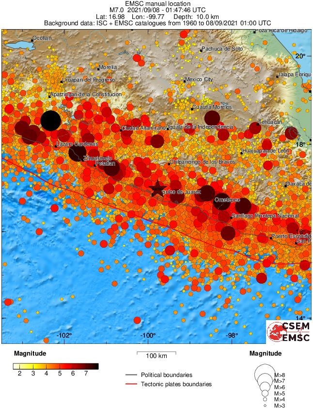
The earthquake resulted from thrust faulting on the subduction zone where the Cocos plate dives down into the mantle beneath the North America plate and Central America, USGS said.
Large earthquakes in the region are common, it added.
This earthquake occurred along a segment of the Middle America subduction zone that is thought capable of producing magnitude 8 or greater earthquakes, and that has not hosted an event larger than magnitude 7 since 1911.
Estimated population exposure to earthquake shaking
Selected cities exposed
Regional seismicity
I'm a dedicated researcher, journalist, and editor at The Watchers. With over 20 years of experience in the media industry, I specialize in hard science news, focusing on extreme weather, seismic and volcanic activity, space weather, and astronomy, including near-Earth objects and planetary defense strategies. You can reach me at teo /at/ watchers.news.
Commenting rules and guidelines
We value the thoughts and opinions of our readers and welcome healthy discussions on our website. In order to maintain a respectful and positive community, we ask that all commenters follow these rules.