
Henri continues dumping heavy rain after making landfall near Westerly, Rhode Island, U.S.
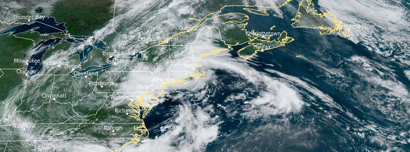
Featured image: Tropical Storm "Henri" at 16:20 UTC on August 22, 2021. Credit: NOAA/GOES-East, RAMMB/CIRA, TW
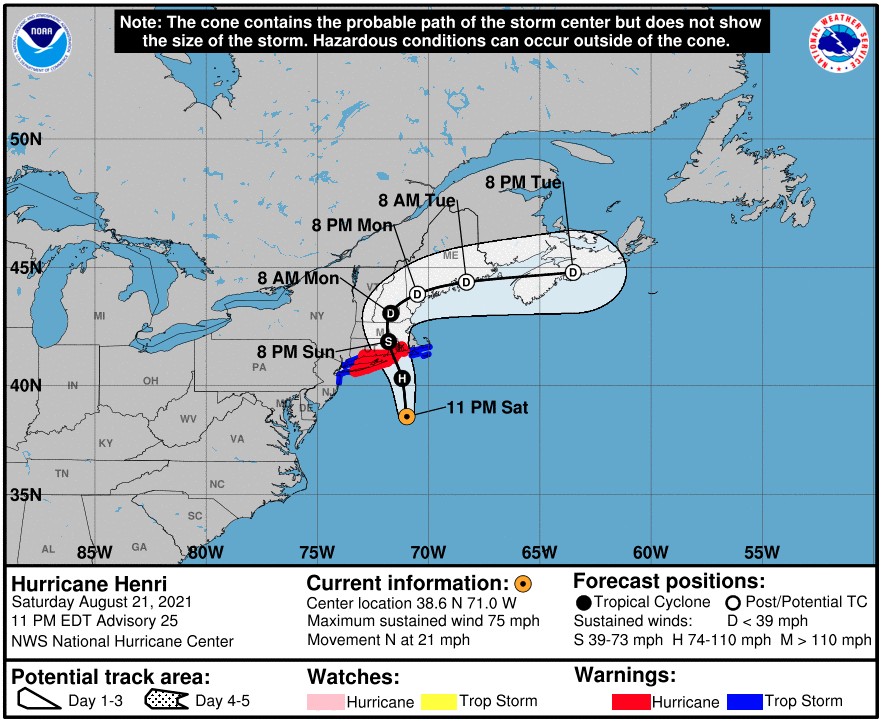
Tropical Storm "Henri" made landfall near Westerly, Rhode Island, U.S. at approximately 16:15 UTC (12:15 EDT) on Sunday, August 22, 2021. At the time of landfall, it had maximum sustained winds of 95 km/h (60 mph) and a minimum central pressure of 989 hPa. Henri slowed down after landfall, weakened into a tropical depression and continued dumping heavy rainfall into Monday, August 23.
At 18:00 UTC on August 22, Henri's center was located about 10 km (6 miles) E of Westerly and 65 km (40 miles) SSW of Providence, Rhode Island. Maximum sustained winds were 80 km/h (50 mph) and the system was moving NW at 15 km/h (9 mph).
By 21:00 UTC, its maximum sustained winds dropped to 65 km/h (40 mph) and to 55 km/h (35 mph) at 00:00 on August 23 — tropical depression.1
At 09:00 UTC on August 23, the center of TD Henri was located about 95 km (60 miles) NNW of New York City and 145 km (90 miles) W of Hartford, Connecticut. The system was moving E at a speed of 2 km/h (1 mph).
More than 140 000 customers lost power at the height of the storm, while heavy rainfall swamped roads and closed bridges.
Most of the rain produced by Henri focused on the western side of the system, 'dousing New Jersey, Pennsylvania, and New York while leaving some areas east of landfall, such as Massachusetts's areas of Cape Cod, Martha's Vineyard and Nantucket.'2
Henri produced 80 to 150 mm (3 to 6 inches) of rainfall over many areas on Sunday, August 22, with parts of central New Jersey receiving as much as 200 mm (8 inches) of rain by midday Sunday. In Jamesburg, television video footage showed flooded downtown streets and cars almost completely submerged. In Newark, Public Safety Director Brian O’Hara said police and firefighters rescued 86 people in 11 incidents related to the storm.3
New England officials fretted that just a few more inches of precipitation would be a backbreaker following a summer of record rainfall, AP reported.
"The ground is so saturated that it can flood with just another inch of rain," Connecticut Gov. Ned Lamont warned late Sunday.3
As of 13:10 UTC on August 23, more than 60 000 customers were still without power — 44 562 in Rhode Island, 8 236 in Connecticut, 5 339 in New Jersey, and 5 174 in Pennsylvania.
Heavy rainfall is expected to continue across portions of southern New England and the northern Mid-Atlantic states through the rest of the day.
Flash Flood Warnings are in effect for parts of far northern New Jersey, central and far southeastern New York, and portions of eastern Pennsylvania Flood Warnings are in effect for portions of central and northern New Jersey, NWS WPC said at 03:00 UTC.4
A Flash Flood Watch is in effect for portions of central New York and northeastern Pennsylvania.
Flood Watches remain in effect for portions of New England, including parts of Massachusetts, New Hampshire, Vermont, and the entirety of Connecticut and Rhode Island.
Flood Watches are also in effect for portions of New Jersey, New York (including Long Island), and Pennsylvania.
Flood Advisories extend from south-central New York southeast through northeastern Pennsylvania and northern New Jersey.
Coastal Flood Advisories remain in effect for portions of the southeastern Massachusetts and New Jersey coastlines.
"Henri is expected to continue weakening today, while very slowly drifting back toward the east over southern New England," NWS forecaster Snell noted at 07:38 UTC on August 23.5
"The main hazard associated with Henri today will be the threat of flash, urban, and river flooding.
"Additional rainfall amounts of 25 – 75 mm (1 to 3 inches) may fall over regions that have already seen several inches of rain in the last 24 hours, leading to added flooding concerns.
"WPC has issued a Moderate Risk (level 3/4) of excessive rainfall between southeast New York and Rhode Island, including Long Island. Flash Flood Watches are also in effect. Henri and all associated hazards are expected to exit the region on Tuesday."
Hurricane Henri's full journey to the Northeast. pic.twitter.com/qdNLreNtU1
— Dakota Smith (@weatherdak) August 24, 2021
A look back on Hurricane Henri's time in the Atlantic Ocean and its trek to the Northeast U.S. pic.twitter.com/sDCMogUYCR
— CIRA (@CIRA_CSU) August 24, 2021
References:
1 Hurricane HENRI Advisory Archive – NOAA
2 Henri leaves its mark from mid-Atlantic to New England – AccuWeather
3 Henri hurls rain as system settles atop swamped Northeast – AP
4 Storm Summary Number 2 for Heavy Rainfall and Wind Associated with Tropical Depression Henri NWS Weather Prediction Center College Park MD 1100 PM EDT Sun Aug 22 2021 – NCEP
5 Short Range Forecast Discussion – NWS Weather Prediction Center College Park MD – 338 AM EDT Mon Aug 23 2021
I'm a dedicated researcher, journalist, and editor at The Watchers. With over 20 years of experience in the media industry, I specialize in hard science news, focusing on extreme weather, seismic and volcanic activity, space weather, and astronomy, including near-Earth objects and planetary defense strategies. You can reach me at teo /at/ watchers.news.
Commenting rules and guidelines
We value the thoughts and opinions of our readers and welcome healthy discussions on our website. In order to maintain a respectful and positive community, we ask that all commenters follow these rules.