
EF3 tornado damages homes near Washburn as five tornadoes hit central Illinois
An EF3 tornado struck the Washburn area of central Illinois on June 10, 2026. The tornado reached a maximum width of 777 m (2 550 feet) and produced winds of up to 249 km/h (155 mph). Three EF1 tornadoes were confirmed near Lincoln’s New Salem, Athens, and Springfield. An EF0 tornado was also reported near Ipava.
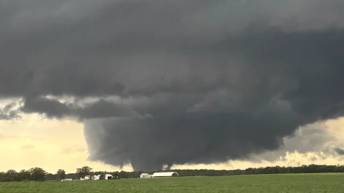
EF3 tornado near Washburn, Illinois on June 11, 2026. Credit: Ben Warren/NWS
At least five tornadoes touched down in central Illinois between June 10 and 11, including an EF3 that struck the Washburn area in Marshall County.
The EF3 developed east of the Illinois River at approximately 16:56 LT on June 10 and tracked northeast for 18.1 km (11.23 miles). It reached a maximum width of 777 m (2 550 feet) and produced peak winds of 250 km/h (155 mph), according to the National Weather Service (NWS).
The tornado intensified in the Columbia Road area, where roofs were blown off multiple homes. It reached EF3 strength northwest of Washburn in rural southern Marshall County. A log house was completely destroyed, while a nearby residence lost its roof and second floor. Survey teams also documented extensive tree damage and significant crop losses.
It continued eastward, damaging additional homes and outbuildings before weakening and dissipating in a farm field northeast of Washburn.
Four additional tornadoes were confirmed across central Illinois on June 11. Three EF1 tornadoes touched down between approximately 09:19 and 10:00 LT in Lincoln’s New Salem, Athens, and Springfield areas, while an EF0 tornado occurred near Ipava later in the day.
The first EF1 tornado developed about 4.8 km (3 miles) northeast of Tallula at 09:19 LT and tracked 7.7 km (4.8 miles) east-northeast before dissipating southwest of Tice at 09:25 LT.
The twister had estimated peak winds of 172 km/h (107 mph) and a maximum width of 137 m (450 feet). It damaged a grain bin and numerous trees near Reimer Avenue, removed shingles from a home along State Park Road, and caused additional tree damage near Lincoln’s New Salem State Historic Site and along Illinois Route 97.
A second EF1 tornado touched down west of Athens along Kent Street at 09:29 LT. The tornado tracked southeast for 4 km (2.5 miles) with peak winds of 169 km/h (105 mph) and a maximum width of 183 m (600 feet) before lifting four minutes later near Fitschen Road on the southern edge of the city. Numerous trees were snapped along its path.
The last EF1 that tracked from Springfield to near Mechanicsburg between 09:35 and 10:00 LT. The tornado remained on the ground for 32.5 km (20.2 miles), reached a maximum width of 229 m (750 feet), and produced peak winds of 177 km/h (110 mph).
It began near Abraham Lincoln Capital Airport, where it lofted 2 722 kg (6 000-lb) storage sheds and rolled an enclosed trailer. Some of the most significant damage occurred at the Animal Protective League shelter on Taintor Road. The tornado continued east-southeast through Camp Butler and Mechanicsburg, causing additional tree damage, structural damage, and power pole failures before dissipating.
Later that evening, an EF0 tornado touched down about 3.2 km (2 miles) southwest of Ipava at 17:17 LT. The weak tornado tracked 3.8 km (2.39 miles) northeast with estimated peak winds of 97 km/h (60 mph) and a maximum width of 27 m (90 feet).
Drone footage showed the tornado damaged several solar panels at a solar farm before moving through Ipava. It crossed Bernadotte Street just south of Main Street and dissipated near the intersection of Kinsey and Mechanic streets. No injuries or fatalities were reported from any of the tornadoes.
The tornadoes were part of a larger severe weather outbreak and derecho that struck communities in Illinois and Indiana on June 10/11.
At least one fatality was confirmed in Iowa as the storm caused widespread damage and left over 680 000 customers without power across 8 U.S. states during the early part of June 12.
Read more:
References:
1 June 10-11, 2026 Severe Weather – NWS – June 12, 2026

I am an Assistant Editor and Severe Weather & Science Journalist at The Watchers, specializing in real-time severe weather coverage, geophysical event reporting, and research-driven scientific analysis. You can reach me at rishav(at)watchers(.)news.

Commenting rules and guidelines
We value the thoughts and opinions of our readers and welcome healthy discussions on our website. In order to maintain a respectful and positive community, we ask that all commenters follow these rules.