
Tropical Storm “Delta” forms near Jamaica, expected to move near or over the Cayman Islands early Tuesday
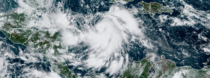
Featured image: Tropical Storm "Delta" at 14:40 UTC on October 5, 2020. Credit: NOAA/GOES-16, RAMMB/CIRA
Tropical Storm "Delta" formed south of Jamaica at 12:00 UTC on October 5, 2020, as the 25th named storm of the 2020 Atlantic hurricane season. The current NHC forecast track takes Delta away from Jamaica today, near or over the Cayman Islands early Tuesday, October 6, near western Cuba Tuesday afternoon and into the southeastern Gulf of Mexico Tuesday night. Delta is the earliest 25th named storm in the Atlantic on record. The previous record was held by Gamma – November 15, 2005.
A Hurricane Warning is in effect for the Cuban province of Pinar del Rio, a Hurricane Watch for Artemisa and Isle of Youth, a Tropical Storm Warning for the Cayman Islands including Little Cayman and Cayman Brac and the Isle of Youth, and a Tropical Storm Watch for the Cuban province of La Habana.
- Tropical storm conditions are expected in the Cayman Islands beginning late today (LT), NHC forecasters noted in their key messages for the system.
- Dangerous storm surge and hurricane conditions are possible in portions of western Cuba and the Isle of Youth by Tuesday afternoon.
- Heavy rainfall will affect portions of Jamaica, the Cayman Islands, and western Cuba during the next few days. This rainfall could lead to significant flash flooding and mudslides.
- The system is forecast to approach the northern Gulf Coast late this week as a hurricane.
- While there is large uncertainty in the track and intensity forecasts at these time ranges, there is a risk of dangerous storm surge, wind, and rainfall hazards along the coast from Louisiana to the western Florida Panhandle. Residents in these areas should monitor the progress of the system.
At 15:00 UTC on October 5, the center of Tropical Storm "Delta" was located about 215 km (135 miles) S of Negril Jamaica and 425 km (265 miles) SE of Grand Cayman.
Delta's maximum sustained winds were 75 km/h (45 mph) and minimum central pressure 1 002 Hpa.
The system was moving W at 11 km/h (7 mph), away from Jamaica, and is expected to turn toward WNW later today.
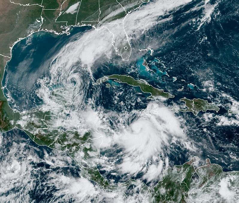
Tropical storms Gamma and Delta at 14:40 UTC on October 5, 2020. Credit: NOAA/GOES-16, RAMMB/CIRA
The current NHC forecast track takes Delta away from Jamaica today, near or over the Cayman Islands early Tuesday, October 6, near western Cuba Tuesday afternoon and into the southeastern Gulf of Mexico Tuesday night.
Additional strengthening is expected during the next few days, and Delta is expected to become a hurricane before it nears western Cuba on Tuesday, NHC said.
A dangerous storm surge will raise water levels by as much as 60 – 120 cm (2 to 4 feet) above normal tide levels along the south coast of western Cuba near and to right of where the center makes landfall. Near the coast, the surge will be accompanied by large and dangerous waves.
Through midweek, Delta is expected to produce 100 – 150 mm (4 to 6 inches) of rain with isolated maximum totals of 205 mm (8 inches) across Jamaica, the Cayman Islands, and western Cuba. This rainfall could lead to significant flash floods and mudslides, NHC warns.
I'm a dedicated researcher, journalist, and editor at The Watchers. With over 20 years of experience in the media industry, I specialize in hard science news, focusing on extreme weather, seismic and volcanic activity, space weather, and astronomy, including near-Earth objects and planetary defense strategies. You can reach me at teo /at/ watchers.news.
Commenting rules and guidelines
We value the thoughts and opinions of our readers and welcome healthy discussions on our website. In order to maintain a respectful and positive community, we ask that all commenters follow these rules.