
Tropical Storm “Sally” strengthening, hurricane and storm surge warnings issued for portions of the U.S. Gulf Coast
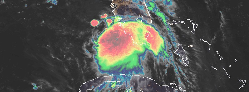
Featured image: Tropical Storm "Sally" at 06:50 UTC on September 13, 2020. Credit: NOAA/GOES-16, RAMMB/CIRA
Tropical Storm "Sally" formed at 18:00 UTC on September 12, 2020, as the earliest 18th named Atlantic storm, beating the previous record set by Stan on September 22, 2005. At the time it formed, Sally's center was located about 60 km (35 miles) SSE of Naples, Florida.
Before it was officially named, Sally was known as Tropical Depression 19 — TD19 made landfall at 06:00 UTC on September 12 just south of Miami, Florida with winds of 55 km/h (35 mph) and a pressure of 1 007 hPa.
- Life-threatening storm surge is possible along the Gulf Coast beginning on Monday, and a Storm Surge Watch is in effect for areas outside the southeastern Louisiana Hurricane and Storm Damage Risk Reduction System from the Mouth of the Mississippi River to the Alabama/Florida border. Residents in these areas should follow any advice given by local officials.
- Hurricane conditions are possible by early Tuesday from Grand Isle, Louisiana to the Alabama/Florida border, including Metropolitan New Orleans, with tropical storm conditions possible by Monday.
- Sally is expected to produce flash flooding across portions of southern Florida and prolong existing minor river flooding across central Florida through Sunday. Flash and urban flooding and minor to moderate river flooding are likely across portions of the central Gulf Coast from Sunday through the middle of next week.
- Tropical storm conditions are possible early next week in portions of the Florida Panhandle, where a Tropical Storm Watch is in effect. Wind gusts to tropical storm force could occur over portions of the lower Florida Keys overnight.
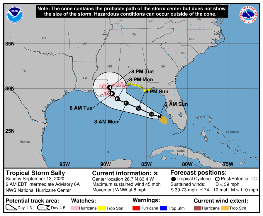
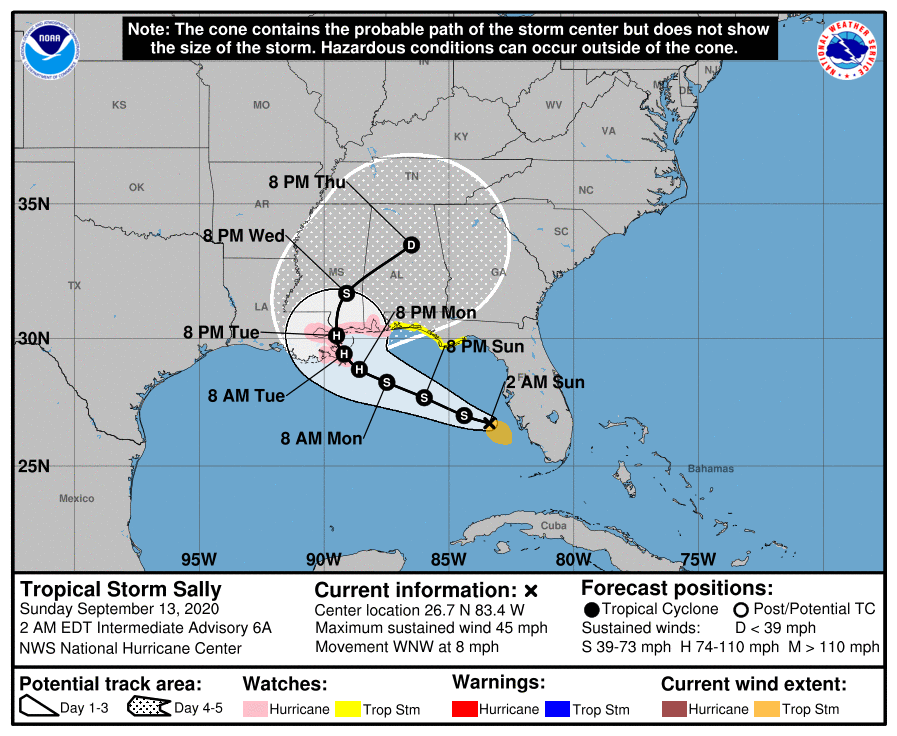
At 06:00 UTC on September 13 (02:00 EDT), the center of Tropical Storm "Sally" was located about 130 km (80 miles) WSW of Port Charlotte, Florida, and 620 km (385 miles) ESE of the Mouth of the Mississippi River.
The storm had maximum sustained winds of 75 km/h (45 mph) and minimum central pressure of 1 003 hPa. It was moving WNW at 13 km/h (8 mph).
Further strengthening is expected over the next couple of days, and Sally is forecast to become a hurricane on Monday, with some additional strengthening possible through early Tuesday.
A Storm Surge Watch is in effect for the Mouth of the Mississippi River to the Alabama/Florida Border, Lake Pontchartrain, Lake Maurepas, and Lake Borgne, Mobile Bay.
A Hurricane Watch is in effect for Grand Isle Louisiana to the Alabama/Florida border, Lake Pontchartrain, and Lake Maurepas including metropolitan New Orleans.
A Tropical Storm Watch is in effect for Alabama/Florida Border to Ochlockonee River Florida.
On the NHC forecast track, the center of Sally will move over the southeastern and eastern Gulf of Mexico today, September 13, move over the north-central Gulf of Mexico Sunday night and Monday, September 14 and approach the north-central Gulf Coast within the hurricane watch area late Monday and Tuesday.
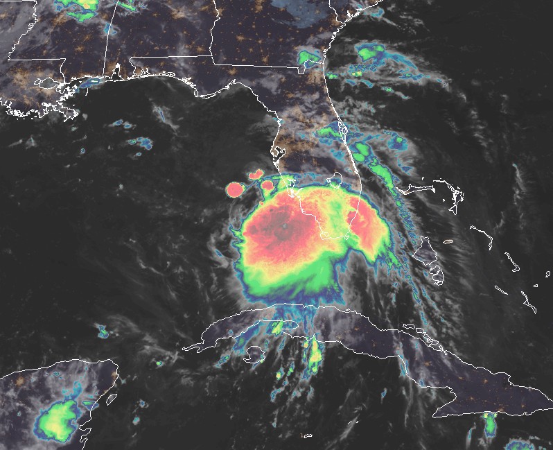
Tropical Storm "Sally" at 06:50 UTC on September 13, 2020. Credit: NOAA/GOES-16, RAMMB/CIRA
"Given the current structure, only gradual strengthening is expected in the short term. However, once the cyclone develops more of an inner core, it should be able to take advantage of warm sea surface temperatures and low shear over the Gulf of Mexico during the next couple of days," NHC forecaster Brennan noted at 03:00 UTC on September 13.
"Steady intensification to hurricane strength is forecast through 48 hours, with a leveling off of the intensity in 60 – 72 hours as the shear is expected to increase."
"Users are reminded to not focus on the exact details of the track or intensity forecasts, as the average NHC track error at 72 h is around 177 km (110 miles) and the average intensity error is around 24 km/h (15 mph). In addition, wind, storm surge, and rainfall hazards will extend far from the center. Unfortunately, confidence is increasing that Sally's expected slow forward speed near the Gulf Coast will exacerbate the storm surge and heavy rainfall threats."
The combination of a dangerous storm surge and the tide will cause normally dry areas near the coast to be flooded by rising waters moving inland from the shoreline, NHC forecasters warned.
The water could reach the following heights above ground somewhere in the indicated areas if the peak surge occurs at the time of high tide:
- Mouth of the Mississippi River to Ocean Springs, MS, including Lake Borgne: 1.8 – 2.7 m (6 – 9 feet).
- Ocean Springs, MS to MS/AL Border: 1.2 – 1.8 m (4 – 6 feet).
- MS/AL Border to AL/FL Border, including Mobile Bay: 0.6 – 1.8 m (2 – 4 feet).
- Lake Pontchartrain and Lake Maurepas: 0.6 – 1.8 m (2 – 4 feet).
- AL/FL Border to Chassahowitzka, FL, including Pensacola Bay, Choctawhatchee Bay, and Saint Andrew Bay: 0.3 – 0.9 m (1 – 3 feet).
The deepest water will occur along the immediate coast near and to the right of the landfall location, where the surge will be accompanied by large and damaging waves. Surge-related flooding depends on the relative timing of the surge and the tidal cycle, and can vary greatly over short distances.
Hurricane conditions are possible within the hurricane watch area by early Tuesday, with tropical storm conditions possible within the watch areas by Monday. Wind gusts to tropical storm force are possible across the lower Florida Keys overnight.
Sally is expected to produce additional rainfall amounts of 50 – 100 mm (2 to 4 inches) with locally higher amounts possible over southern Florida and the Florida Keys through today. Rainfall amounts of 50 – 100 mm (2 to 4 inches) with isolated amounts of 150 mm (6 inches) are expected along the west coast of Florida through today. This rainfall will produce flash and urban flooding across southern Florida and prolong high flows and ongoing minor flooding on rivers across central Florida. Sally is expected to produce rainfall amounts of 125 – 250 mm (5 to 10 inches) across the Florida Panhandle, and 150 – 300 mm (6 to 12 inches) with isolated amounts of 460 mm (18 inches) over the Central Gulf Coast from Sunday into the middle of next week, with 75 – 150 mm (3 to 6 inches) rainfall amounts possible over inland portions of Mississippi and Alabama.
Sally is expected to be a slow-moving system that will continue to produce heavy rainfall and considerable flooding near the central Gulf Coast through the middle of next week. Flash, urban, and rapid onset flooding along small streams and minor to moderate flooding on rivers are likely.
Swells will spread northward along the west-central coast of Florida and reach the Florida Panhandle and the northern Gulf Coast during the next couple of days. These swells are likely to cause life-threatening surf and rip current conditions.
A tornado is possible overnight along the south Florida Gulf Coast.
I'm a dedicated researcher, journalist, and editor at The Watchers. With over 20 years of experience in the media industry, I specialize in hard science news, focusing on extreme weather, seismic and volcanic activity, space weather, and astronomy, including near-Earth objects and planetary defense strategies. You can reach me at teo /at/ watchers.news.
Commenting rules and guidelines
We value the thoughts and opinions of our readers and welcome healthy discussions on our website. In order to maintain a respectful and positive community, we ask that all commenters follow these rules.