
Hurricane “Paulette” intensifying on its way toward Bermuda
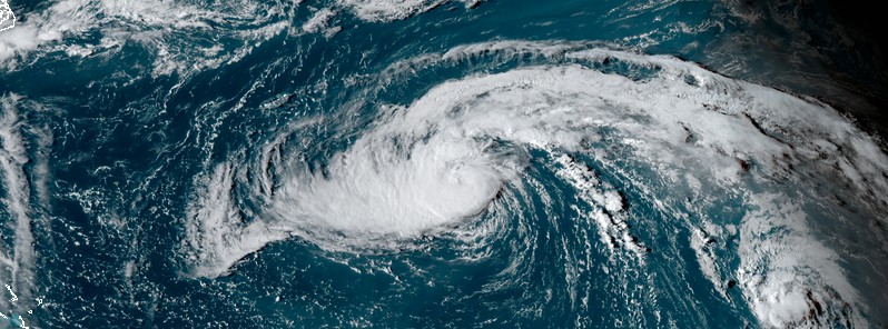
Featured image: Tropical Storm "Paulette" at 20:00 UTC on September 12, 2020. Credit: NOAA/GOES-16, RAMMB/CIRA
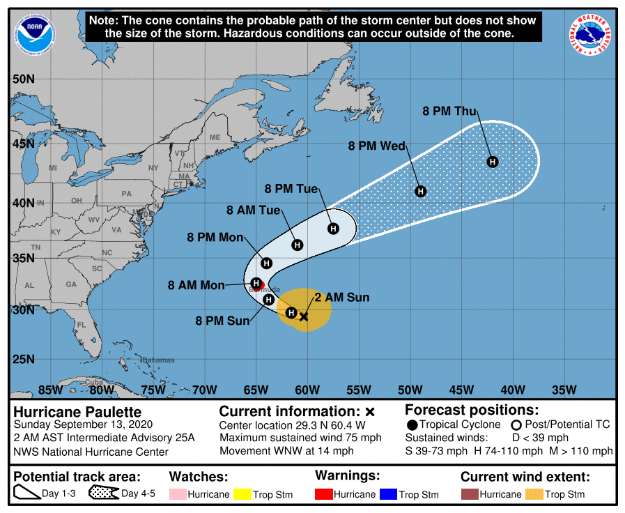
Tropical Storm "Paulette" formed at 15:00 UTC on September 7 as the earliest 16th named Atlantic storm, breaking the previous record set by Philippe on September 17, 2005. The storm intensified into a hurricane at 03:00 UTC on September 13 — the 6th of the 2020 Atlantic season to date. The average full Atlantic hurricane season has 6 hurricanes. A Hurricane Warning is in effect for Bermuda.
- Paulette is expected to approach Bermuda as a hurricane on Sunday, September 13, and be near the island Sunday night (LT) and Monday, NHC warns.
- A prolonged period of strong winds, storm surge, and heavy rainfall is expected on Bermuda beginning Sunday evening. Preparations to protect life and property should be rushed to completion.
- Swells produced by Paulette are affecting portions of the Leeward Islands, the Greater Antilles, the Bahamas, Bermuda, and the east coast of the United States. These swells could cause life-threatening surf and rip current conditions.
At 06:00 UTC today, the center of Hurricane "Paulette" was located 535 km (330 miles) SE of Bermuda, heading WNW at 22 km/h (14 mph). Its maximum sustained winds were 120 km/h (75 mph), making it a Category 1 hurricane. The storm's minimum central pressure was 981 hPa.
A turn toward the north with a decrease in forward speed is forecast on Monday, September 14, followed by a northeast motion Monday night (LT) and Tuesday.
The center of Paulette is expected to move near or over Bermuda Monday morning (LT), possibly as a Category 2 hurricane or even Category 3.
If Paulette makes landfall in Bermuda, it will be their first landfall since October 2014 hurricanes Fay and Gozalo.
"Despite Bermuda's strict building codes, property damage and power outages are likely even if Paulette brushes the islands, and more widespread damage and power outages are expected if the storm makes a direct hit as a Category 2 hurricane or higher," AccuWeather meteorologists said.
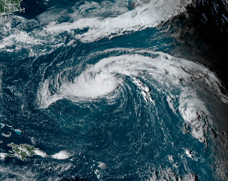
Tropical Storm "Paulette" at 20:00 UTC on September 12, 2020. Credit: NOAA/GOES-16, RAMMB/CIRA
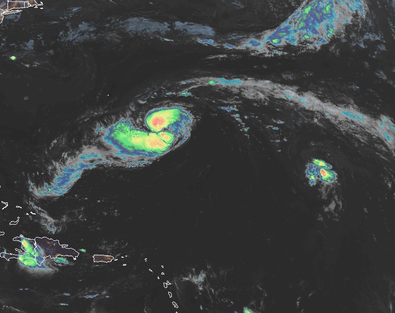
Hurricane "Paulette" at 06:50 UTC on September 13, 2020. Credit: NOAA/GOES-16, RAMMB/CIRA
"Paulette appears to be getting more vertically aligned as the shear that has affected the cyclone for the past several days slowly decreases," NHC forecaster Zelinsky noted.
"Further intensification appears likely through early Monday given the warm sea surface temperatures below Paulette and favorable upper-air environment that is expected to develop around the cyclone. Dry air in the surrounding environment could be a limiting factor, but all of the intensity guidance continues to indicate that Paulette will be a dangerous hurricane when it approaches Bermuda late Sunday and early Monday."
"Further intensification will then be possible for another day or so after the hurricane begins to move away from Bermuda and it could be near major hurricane strength by the middle of next week."
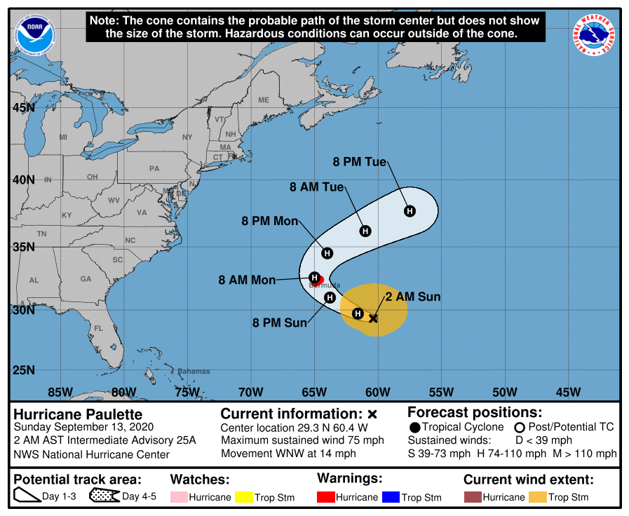
Hurricane conditions are expected to reach Bermuda by Sunday night or early Monday (AST). Winds are expected to first reach tropical storm strength this afternoon or evening, making outside preparations difficult or dangerous. Preparations to protect life and property should be rushed to completion, NHC said.
A dangerous storm surge is expected to produce significant coastal flooding on Bermuda in areas of onshore winds. Near the coast, the surge will be accompanied by large and destructive waves.
Paulette will likely bring periods of heavy rain to Bermuda today through Monday, with rainfall of 75 – 150 mm (3 to 6 inches) likely.
Swells generated by Paulette are affecting portions of the Leeward Islands, the Greater Antilles, the Bahamas, Bermuda, and the east coast of the United States. These swells are likely to cause life-threatening surf and rip current conditions.
I'm a dedicated researcher, journalist, and editor at The Watchers. With over 20 years of experience in the media industry, I specialize in hard science news, focusing on extreme weather, seismic and volcanic activity, space weather, and astronomy, including near-Earth objects and planetary defense strategies. You can reach me at teo /at/ watchers.news.
Hurricane Humberto hit us in Bermuda just last year almost to the day. Just FYI
Hurricane “Humberto” made a close encounter with Bermuda on Tuesday night, September 17, 2019, as a Category 3 hurricane. https://watchers.news/2019/09/21/hurricane-humberto-pounds-bermuda-remnants-to-reach-the-british-isles-early-next-week/