
Powerful storm kills 5 across the Southeast, heavy snow and freezing rain continues across the Northeast, U.S.
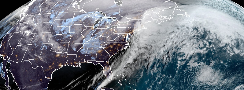
Image credit: NOAA/GOES-East, RAMMB/CIRA. Acquired: 12:40 UTC, February 7, 2020
A powerful winter storm hit the Southeast U.S. on Thursday, February 6, 2020, killing at least 5 people and wreaking havoc across the region. The storm will continue to bring heavy and snow and freezing rain for the interior Northeast on Friday, February 7, before drying out by Sunday, February 9, according to the National Weather Service (NWS).
Roughly 200 000 homes and businesses in the southeastern region were without power early Friday, February 7, with Florida bearing the brunt of the outages as 75 000 customers were affected in the state. The Carolinas, Georgia, and Virginia also reported outages.
As of 13:14 UTC on February 7, 127 718 customers were without power in North Carolina, 67 211 in Pennsylvania, 43 797 in Florida, 39 939 in South Carolina, and 22 912 in Virginia — total: 301 577.
SPC received 12 tornado reports on February 5, most of them from Mississippi and Alabama, and 11 on February 6, most of them from North Carolina (and one each in South Carolina and Florida).
Authorities reported that the storm left a trail of destruction, with mobile homes destroyed in Mississippi and Alabama; mudslides in Tennessee and Kentucky, and inundations across the Appalachian region.
Virginia was placed under a state of emergency on Thursday as over 500 people in the southwestern area were displaced.
Several schools had to cancel classes as the severe weather continued. In Tennessee, authorities warned people living near rivers and lakes to prepare for changing water levels.
At least four people died in Alabama, South Carolina, North Carolina, and Tennesee in storm-related incidents.
One person was killed while another was injured after strong winds ravaged two mobile homes near the town of Demopolis, Alabama. In addition, three people were killed in weather-related crashes.
In South Carolina, a driver died when a tree fell on an SUV near Fort Mill. In North Carolina, a person lost his life after his pickup truck overturned in a creek, according to the State Highway Patrol.
Lastly, an unidentified man was killed when a car hydroplaned in Knoxville, Tennesee, and collided with a truck.
The storm system that spawned the severe weather is also responsible for bringing record snowfall to parts of the central U.S.
"As this storm system targets the interior Northeast with heavy snowfall to end the week, colder, drier air will rush into the areas affected by severe weather in the South," AccuWeather Meteorologist Renee Duff said.
According to NWS, heavy snow and freezing rain will continue for the Northeast on Friday, February 7.
"A surface low-pressure system is expected to consolidate and strengthen rapidly in the Mid-Atlantic moving into the Northeast," the agency stated in its forecast.
"This low and the strong jet stream will lead to heavy snow of over a foot for northern New York and New England north and west of the low."
Moreover, an area of freezing rain is expected for portions of north-central Pennsylvania and central New York, with heavier ice amounts for southern Vermont, New Hampshire, and along the coast of Maine.
"Potentially record-setting above-average temperatures will keep precipitation in the form of rain closer to the Atlantic coast of New York and southern New England."
Widespread wind advisories were issued along the Eastern Seaboard as breezy winds behind the cold front are expected. NWS noted that this low is likely to set low-pressure records of February in parts of the northern Mid-Atlantic to the Northeast.
The low is forecast to move out of the country by Friday night. However, light snow may continue in the lower Great Lakes region and in the Central Appalachians, while a weaker low-pressure will spread light snows across the Midwest to Ohio Valley and Upper Great Lakes, and result in another possible round of light snow for the Appalachians and parts of the Mid-Atlantic into the weekend.
"In the West, a low-pressure system will move southeastward into British Columbia today and then into the Northern High Plains by Saturday morning. Another round of precipitation is expected with this frontal system, with rain in the lowest elevations and heavy snow in higher elevations."
The winter storm will rapidly strengthen Friday while lifting north across the Northeast. Heavy snow and blowing snow will make for dangerous travel from the E. Great Lakes into northern Maine. Freezing rain/wintry mix will create icy roads from Pennsylvania into southern Maine. pic.twitter.com/JBvyiGuJEf
— National Weather Service (@NWS) February 7, 2020
Commenting rules and guidelines
We value the thoughts and opinions of our readers and welcome healthy discussions on our website. In order to maintain a respectful and positive community, we ask that all commenters follow these rules.