
Recently returned residents flee after new eruption at Ulawun vlcano, Papua New Guinea
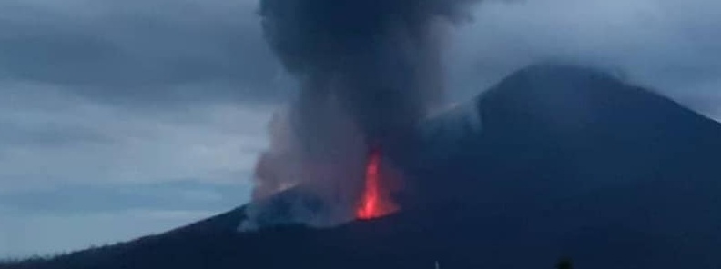
Image credit: Alfred Jules
Papua New Guinea's Ulawun volcano erupted early October 1, 2019, after a brief period of very high seismicity detected since September 30. The eruption forced recently returned residents to flee again.
The eruption ejected volcanic ash up to 6 km (20 000 feet) above sea level, according to the Darwin VAAC.
"Continuous plume is visible on latest satellite imagery extending SW. Weak volcanic ash signal in RGB imagery suggests plume is ash poor. A hotspot is visible on the SW flank of the volcano," the center said at 12:55 UTC.
Further eruptions to higher levels remain possible, it added.
Although most of the people affected by the previous eruptions are still at evacuation centers, some of them returned to tend to their homes and gardens at the base of the volcano. They were now forced to evacuate again, an official within the West New Britain Disaster Office told AFP.
#Ulawun volcano erupted on 1 Oct 2019 after an extremely high Real Time Seismic Amplitude Measurement was noted. Incandescent fountain surmounted by tall ash-laden plume was seen being spewed from the eruptive vent at the base of the cone- Chris Lagisa's Photo via Sherine France pic.twitter.com/LYh7HT4xXI
— jaime s. sincioco (@jaimessincioco) October 1, 2019
The volcano produced a series of powerful eruptions since June 26, forcing at least 15 000 people to evacuate. Major stratospheric eruption were recorded on June 26 and August 3, with volcanic ash up to 19.2 km (63 000 feet) above sea level.
That is just spectacular!… #Ulawun eruption! Photo credit: Eroli Tamarahttps://t.co/dCY6RZUmQW pic.twitter.com/K2kmJhKtFY
— Szabolcs Harangi (@szharangi) June 26, 2019
Geological summary
The symmetrical basaltic-to-andesitic Ulawun stratovolcano is the highest volcano of the Bismarck arc, and one of Papua New Guinea's most frequently active.
Ulawun volcano, also known as the Father, rises above the north coast of the island of New Britain across a low saddle NE of Bamus volcano, the South Son.
The upper 1 000 m (3 280 feet) of the 2334-m-high (7 657 feet) Ulawun volcano is unvegetated.
A prominent E-W-trending escarpment on the south may be the result of large-scale slumping. Satellitic cones occupy the NW and eastern flanks. A steep-walled valley cuts the NW side of Ulawun volcano, and a flank lava-flow complex lies to the south of this valley.
Historical eruptions date back to the beginning of the 18th century. Twentieth-century eruptions were mildly explosive until 1967, but after 1970 several larger eruptions produced lava flows and basaltic pyroclastic flows, greatly modifying the summit crater.
I'm a dedicated researcher, journalist, and editor at The Watchers. With over 20 years of experience in the media industry, I specialize in hard science news, focusing on extreme weather, seismic and volcanic activity, space weather, and astronomy, including near-Earth objects and planetary defense strategies. You can reach me at teo /at/ watchers.news.
Commenting rules and guidelines
We value the thoughts and opinions of our readers and welcome healthy discussions on our website. In order to maintain a respectful and positive community, we ask that all commenters follow these rules.