
Center of Hurricane “Florence” makes landfall near Wrightsville Beach, North Carolina
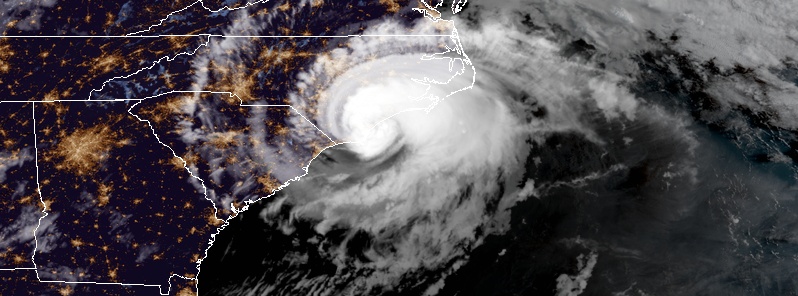
Featured image: Hurricane "Florence" at 11:45 UTC on September 14, 2018. Credit: NOAA/GOES-East
NOAA Doppler weather radar data and surface observations indicate that the center of the eye of Hurricane "Florence" made landfall along the coast of North Carolina at 07:15 EDT (11:15 UTC) on September 14, 2018 near 34.2N 77.8W, which is near Wrightsville Beach. Maximum sustained winds were estimated to be 150 km/h (90 mph), and the central pressure was estimated to be 958 hPa based on reports from the NOAA NOS observing station at Johnny Mercer Pier in Wrightsville Beach. This placed Florence on the upper edge of Category 1 hurricane on the Saffir-Simpson scale.
As of 12:00 UTC today, there are more than 437 000 customers across North and South Carolina without power and this number could grow to millions before the day ends. The hurricane is producing devastating storm surge, winds gusts, tornadoes and flash flooding throughout eastern North Carolina.
Florence has slowed down to a crawl as expected and has already dumped more than a 305 mm (1 foot) of rain at several locations.
About 70 people have been evacuated from the Triangle Motor Inn in Jacksonville, North Carolina, after hurricane-force winds compromised the hotel's structural integrity.
Storm surge caused the Neuse River in New Bern to overflow its banks, flooding roads, stranding residents and causing a local news station to evacuate its buildings while they were still on air. Two meteorologists stayed on-air to inform the public and were the last to leave. They left the set as a radar loop of Florence played in the background.
Our sister station, WCTI has been evacuated due to water rising around the building due to storm surge. Please keep them in your thoughts. pic.twitter.com/Et1ueYUCvc
— Ricky Matthews (@wxrjm) September 13, 2018
Eerie video as WCTI's meteorologists finally evacuate due to rising waters mid-broadcast, leaving just the radar of Florence's rain bands looping on repeat pic.twitter.com/9vxFqB8ZXl
— Brian L Kahn (@blkahn) September 14, 2018
Update: flood waters feet deep with debris floating in New Bern, NC in Johnson Street, blocks from the river. Tide coming up again #HurricaneFlorence @accuweather @breakingweather pic.twitter.com/H95gU2UfEZ
— Reed Timmer (@ReedTimmerAccu) September 14, 2018
Some 150 people in the city, home to about 30 000, are reportedly waiting to be rescued. The entire city is under mandatory evacuation.
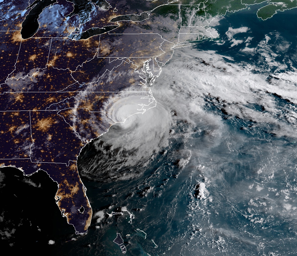
Hurricane "Florence" at 11:45 UTC on September 14, 2018. Credit: NOAA/GOES-East
Port city of Wilmington, NC has recorded a wind gust of 170 km/h (105 mph), its highest in 60 years and second highest ever after 217 km/h (135 mph) produced by Hurricane "Helene" on September 27, 1958.
At 12:00 UTC on September 14, the center of Florence was located 15 km (10 miles) south of Wilmington and 105 km (65 miles) southwest of Myrtle Beach, SC. The storm is moving W at 9 km/h (6 mph) with minimum central pressure of 958 hPa and maximum sustained winds of 150 km/h (90 mph).
A slow westward to west-southwestward motion is expected today through Saturday. On the forecast track, the center of Florence will move further inland across extreme southeastern North Carolina and extreme eastern South Carolina today and Saturday. Florence will then move generally northward across the western Carolinas and the central Appalachian Mountains early next week.
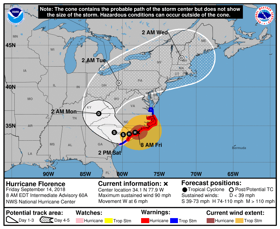
Gradual weakening is forecast later today and tonight. Significant weakening is expected over the weekend and into early next week while Florence moves farther inland.
Southeastern coastal North Carolina into far northeastern South Carolina is expected to receive an additional 508 to 635 mm (20 to 25 inches) of rainfall, with isolated storm totals of 762 to 1 067 mm (30 to 40 inches.)
This rainfall will produce catastrophic flash flooding and prolonged significant river flooding.
Update
September 17 at 09:00 UTC:
brought historic and record-breaking rainfall, left more than 1 million customers without power and claimed lives of at least 17 people. This event is still not over and in some parts of North Carolina, the worst is yet to come. Read more
I'm a dedicated researcher, journalist, and editor at The Watchers. With over 20 years of experience in the media industry, I specialize in hard science news, focusing on extreme weather, seismic and volcanic activity, space weather, and astronomy, including near-Earth objects and planetary defense strategies. You can reach me at teo /at/ watchers.news.
Jeremiah 4:13 Behold, he goes up like the whirlwind; His horses are swifter the eagles Who to us, for we are ruined!!!” Hoses 8:7 For they sow the wind and they reap the whirlwind The standing grain has no heads; it yields no grain. Should it yield, strangers would swallow it up. Indeed this is the fate for now on that will even await the hole world of mankind. Your harvest is being taken away,” and they know it!