
Models suggest significant windstorm is about to hit Ireland and UK
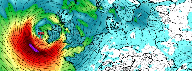
Featured image: Models suggest significant windstorm is about to hit Ireland and UK on October 21 and 22, 2017. Credit: TropicalTidbits.com
A new tropical depression may strengthen into a strong storm to hurricane force cyclone as it crosses the Atlantic and approaches Ireland and the United Kingdom over the next couple of days.
"GFS and ECMWF model guidance is currently in good agreement on the new tropical depression that may affect the British Isles and Ireland," meteorologists at the Severe Weather Europe report. "Invest 92L, as the depression is currently designated, may strengthen into a strong storm to hurricane force cyclone as it crosses the Atlantic and approaches Ireland and UK."
At this time, GFS model guidance indicates a very deep cyclone with central pressure approaching 960 hPa and peak wind gusts of 120 – 130 km/h (75 – 80 mph) around potential landfall. ECMWF indicates an only slightly weaker system at 970 hPa central pressure.
I'm a dedicated researcher, journalist, and editor at The Watchers. With over 20 years of experience in the media industry, I specialize in hard science news, focusing on extreme weather, seismic and volcanic activity, space weather, and astronomy, including near-Earth objects and planetary defense strategies. You can reach me at teo /at/ watchers.news.
Commenting rules and guidelines
We value the thoughts and opinions of our readers and welcome healthy discussions on our website. In order to maintain a respectful and positive community, we ask that all commenters follow these rules.