
Katia now dangerous Category 2 hurricane, crawling toward Mexico
Featured image: Hurricane "Katia" at 15:45 UTC on September 8, 2017 with forecast track. Credit: UW-CIMSS
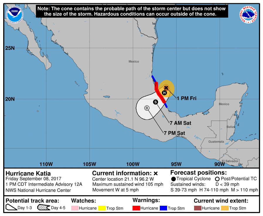
Category 2 Hurricane "Katia" is slowly moving toward the coast of eastern Mexico and is expected to make landfall near or at major hurricane strength early Saturday morning (CDT), September 9, 2017, somewhere between Nautla and Monte Gordo, Veracruz.
- A dangerous storm surge will raise water levels by as much as 1.5 and 2.1 m (5 to 7 feet) above normal tide levels near and to the north of where Katia makes landfall.
- Katia is expected to produce total rain accumulations of 254 to 381 mm (10 to 15 inches) over northern Veracruz, eastern Hidalgo, and Puebla. Total rain accumulations of 50.8 to 127 mm (2 to 5 inches) over southern Tamaulipas, eastern San Luis Potosi, western Hidalgo, eastern Queretaro, and southern Veracruz through Saturday evening. Isolated maximum amounts of 635 mm (25 inches) are possible in northern Veracruz, eastern Hidalgo, Puebla, and San Luis Potosi. This rainfall will likely cause life-threatening flash floods and mudslides, especially in areas of mountainous terrain.
- Swells generated by this hurricane will continue to affect portions of the coast of southeastern Mexico during the next couple of days.
Preparations to protect life and property should be rushed to completion.
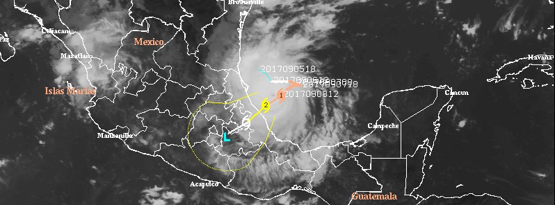
As of 18:00 UTC on September 8, 2017, the center of Hurricane "Katia" was located 220 km (135 miles) ESE of Tampico and 210 km (130 miles) NNE of Veracruz, Mexico.
The system has maximum sustained winds of 165 km/h (100 mph) and the minimum central pressure of 974 hPa. This places Katia on the upper edge of Category 2 hurricane on the Saffir-Simpson Hurricane Wind Scale.
Additional strengthening is forecast and Katia could be near or at major hurricane strength (Category 3) by the time of landfall. Category 3 hurricanes have maximum sustained winds between 178 – 208 km/h (111-129 mph).
Katia has a minimum central pressure of 974 hPa and is moving WSW at a speed 9 km/h (5 mph). This general motion is expected to continue through landfall area early Saturday (CDT), September 9.
A Hurricane Warning is in effect for:
- Cabo Rojo to Laguna Verde
A Hurricane Warning means that hurricane conditions are expected somewhere within the warning area, in this case within 12 to 24 hours. Preparations to protect life and property should be rushed to completion.
A Tropical Storm Warning is in effect for:
- North of Cabo Rojo to Rio Panuco
- South of Laguna Verde to Puerto Veracruz
A Tropical Storm Warning means that tropical storm conditions are expected somewhere within the warning area, in this case within 24 hours.
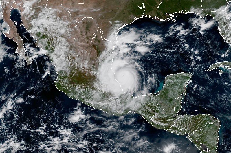
Hurricane "Katia" at 17:30 UTC on September 8, 2017. Credit: NOAA/GOES-16 (preliminary and non-operational)
Hazards affecting land
A dangerous storm surge will raise water levels by as much as 1.5 and 2.1 m (5 to 7 feet) above normal tide levels near and to the north of where Katia makes landfall. Near the coast, the surge will be accompanied by large and destructive waves.
Katia is expected to produce total rain accumulations of 254 to 381 mm (10 to 15 inches) over northern Veracruz, eastern Hidalgo, and Puebla. Total rain accumulations of 50.8 to 127 mm (2 to 5 inches) over southern Tamaulipas, eastern San Luis Potosi, western Hidalgo, eastern Queretaro, and southern Veracruz through Saturday evening. Isolated maximum amounts of 635 mm (25 inches) are possible in northern Veracruz, eastern Hidalgo, Puebla, and San Luis Potosi. This rainfall will likely cause life-threatening flash floods and mudslides, especially in areas of mountainous terrain.
Hurricane conditions are expected within portions of the hurricane warning area by tonight or early Saturday, with tropical storm conditions expected within the tropical storm warning areas by later today.
Swells generated by Katia will continue to affect portions of the coast of southeastern Mexico during the next couple of days. These swells are likely to cause life-threatening surf and rip current conditions.
I'm a dedicated researcher, journalist, and editor at The Watchers. With over 20 years of experience in the media industry, I specialize in hard science news, focusing on extreme weather, seismic and volcanic activity, space weather, and astronomy, including near-Earth objects and planetary defense strategies. You can reach me at teo /at/ watchers.news.
Commenting rules and guidelines
We value the thoughts and opinions of our readers and welcome healthy discussions on our website. In order to maintain a respectful and positive community, we ask that all commenters follow these rules.