
Harvey breaks record for most rainfall from tropical cyclone in the contiguous US
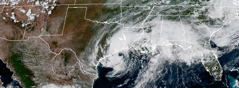
Featured image: Tropical Storm "Harvey" at 21:00 UTC on August 29, 2017. Credit: NOAA/GOES-16 (preliminary and non-operational)
Although it's still not over, Tropical Cyclone "Harvey" has now dumped more rain on the contiguous United States than any previous tropical cyclone since records began. The most rainfall produced by any tropical cyclone in the entire US was 1 320.8 mm (52 inches) in 1950. This record will most definitely be broken too, most likely by the end of the day.
"With 1 249.7 mm (49.29 inches) measured at Mary's Creek at Winding Road, Texas, the record for total rainfall from a tropical system in the contiguous US has been broken," NWS Houston said August 29, 2017. The station received this much rain between 17:00 UTC (12:00 CDT) on August 25 and 14:20 UTC (09:20 CDT) on August 29.
Just a couple of hours later, the office said that the Cedar Bayou gauge, east of Highlands, Texas, recorded 1 317.75 mm (51.88 inches) of rain as of 20:00 UTC (15:00 CDT) on August 29.
The previous contiguous US record was 1 219.2 mm (48 inches), measured at Medina, Texas, during Tropical Storm "Amelia" in 1978.
The record for total rainfall from a tropical system has been BROKEN! Mary's Creek at Winding Road recorded 49.20", previous record is 48". pic.twitter.com/yCjuUOR8p3
— NWS Houston (@NWSHouston) August 29, 2017
Update to the rainfall record: 51.88" has been reported at Cedar Bayou and FM-1942 as of 3:40 PM CDT today #houwx #glswx #bcswx #txwx pic.twitter.com/LJZsLJSqVm
— NWS Houston (@NWSHouston) August 29, 2017
The entire US record is 1 320.8 mm (52 inches), measured in 1950 in Hawaii during Hurricane "Hiki," over the course of 4 days. However, with more heavy rain in the forecast, Harvey will most definitely break that record, too.
For comparison, the most rainfall dumped by any tropical cyclone in the world is 6 433 mm (253.27 inches) in Commerson, La Reunion produced by Tropical Cyclone "Hyacinthe" in 1980. This very mountainous region is also holding the second highest tropical cyclone rainfall record of 5 512 mm (217.01 inches), produced by Tropical Cyclone "Gamede" in 2007, and world records for 12-hour, 24-hour, 48-hour, 72-hour, 96-hour and 10-day rainfall produced by a tropical cyclone.
Harvey is now crawling toward the coast again dumping more catastrophic rains over southeastern Texas and southwestern Louisiana.
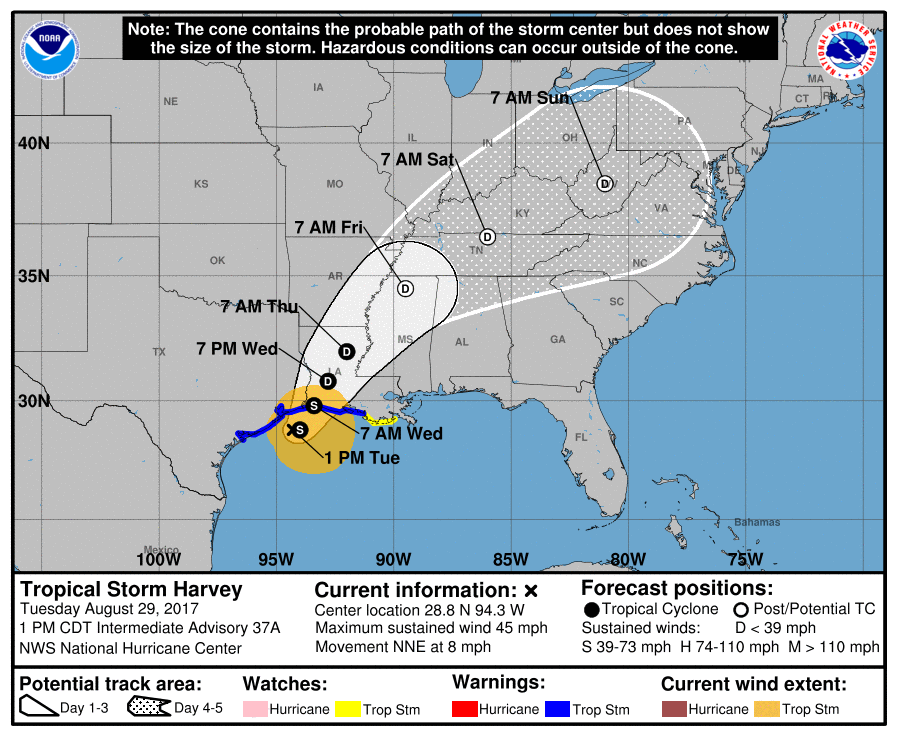
As of 21:00 UTC (16:00 CDT) on August 29, the center of Tropical Storm "Harvey" was located about 85 km (55 miles) SSW of Port Arthus, Texas and 115 km (75 miles) of Cameron, Louisiana. The system has maximum sustained winds of 85 km/h (50 mph) and is moving NNE at 9 km/h (6 mph) with an estimated minimum central pressure of 994 hPa.
This general motion is expected to continue tonight and tomorrow and the broad circulation of Harvey is expected to move inland over the northwestern Gulf Coast within the Tropical Storm Warning area by early Wednesday (local time), August 30.
A life-threatening Storm Surge Warning is in effect from Port Bolivar to west of Holly Beach and from Holly Beach to Morgan City. A Tropical Storm Warning is in effect from north of Port O'Connor to Morgan City. A Tropical Storm Watch is in effect for east of Morgan City to Grand Isle.
Tropical storm conditions are occurring over portions of the warning area along the coast and are likely to persist during the next day or so. Tropical storms conditions are possible within the watch area within the next 24 hours.
Harvey is expected to produce additional rainfall accumulations of 152.4 to 304.8 mm (6 to 12 inches) to the north and east of Houston from far east Texas into southwestern Louisiana. Isolated storm totals will reach 1 270 mm (50 inches) over the upper Texas coast, including the Houston/Galveston metropolitan area. These rains are currently producing catastrophic and life-threatening flooding over large portions of southeastern Texas and southwestern Louisiana.
Elsewhere, Harvey is expected to produce total rainfall amounts of 127 to 254 mm (5 to 10 inches) across portions of southern Louisiana into coastal Mississippi and Alabama. Rainfall associated with Harvey will spread north by mid to late week, with rainfall amounts of 101.6 to 203.2 mm (4 to 8 inches) spreading into portions of Arkansas and the Tennessee Valley.
The combination of a dangerous storm surge and the tide will cause normally dry areas near the coast to be flooded by rising waters moving inland from the shoreline. The water is expected to reach the following heights above ground if the peak surge occurs at the time of high tide:
Holly Beach to Morgan City: 61 – 122 cm (2 to 4 feet)
San Luis Pass to west of Holly Beach including Galveston Bay: 30 to 91 cm (1 to 3 feet)
The deepest water will occur along the immediate coast near the area of onshore winds. Surge-related flooding depends on the relative timing of the surge and the tidal cycle, and can vary greatly over short distances.
Swells generated by Harvey are still affecting the coasts of Texas and Louisiana. These swells are likely to cause life-threatening surf and rip current conditions.
A few tornadoes are possible today from extreme southeast Texas across parts of southern Louisiana, coastal Mississippi, and coastal Alabama.
I'm a dedicated researcher, journalist, and editor at The Watchers. With over 20 years of experience in the media industry, I specialize in hard science news, focusing on extreme weather, seismic and volcanic activity, space weather, and astronomy, including near-Earth objects and planetary defense strategies. You can reach me at teo /at/ watchers.news.
Commenting rules and guidelines
We value the thoughts and opinions of our readers and welcome healthy discussions on our website. In order to maintain a respectful and positive community, we ask that all commenters follow these rules.