
Powerful hailstorm hits Colorado, leaving widespread damage
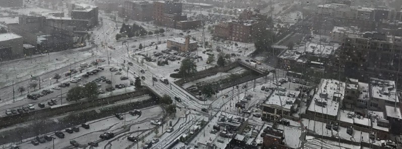
Featured image: Downtown Denver covered in a thick layer of ice. Credit: Jon Olafson
A severe thunderstorm hit Colorado on Monday, May 8, 2017, dumping hail as large as tennis balls. The storm blanketed the state in a thick layer of ice, leaving widespread damage and traffic delays. Hundreds if not thousands of vehicles and buildings were damaged.
Although most of the hailstones did not exceed the size of golfballs some of them were as big as tennis balls and there are even reports of hail larger than a pool ball.
A severe thunderstorm moved over Denver shortly after 15:00 MDT and was very slow-moving, AccuWeather Meteorologist Brian Edwards said. "Since the storm was barely moving, hail piled up several inches, causing widespread travel problems in the metro area."
Air traffic was also impacted as more than 150 flights at Denver international Airport had to be delayed.
Lime-sized hailstones are responsible for closing the Colorado Mills Mall in Lakewood until Wednesday. As many as three inches of water filled most of the mall, forcing security to close the mall and forcing stores to get new inventory, 9NEWS reported. Hundreds of cars in the mall’s parking lot were damaged as well. Baseball-sized holes in the rear windshield were commonplace, while dents were even more so.
There were no reports of injuries.
Ridiculous 30-sec VIS imagery from GOES-16 over the #Colorado severe storms this afternoon – data preliminary and non-operational #cowx pic.twitter.com/fEbt3kSNkk
— Dan Lindsey (@DanLindsey77) May 8, 2017
Meso circulation in Elbert, County, to funnel, to brief tornado, to hail covering I-70 near Agate #COwx pic.twitter.com/uIvGjxejjR
— Cory Reppenhagen (@CRepp7News) May 8, 2017
(Prelim/Non-oper) 30-second #GOES16 Visible & Infrared images w/SPC reports of hail size eastern #COwx https://t.co/4GavX9QvZg @NWSBoulder pic.twitter.com/N0UjqiO9gy
— Scott Bachmeier (@CIMSS_Satellite) May 9, 2017
Wow! Some intense hail in downtown Denver! #Cowx @9NEWS pic.twitter.com/7slSHqvA9r
— Jon Olafson (@JonnyOla) May 8, 2017
Funnel cloud in #Agate, CO Today. Tor warned storm produced destructive hail stones up to hen eggs. : @BrettNoble4, @WilliamScherer3 #COwx pic.twitter.com/hfuLkgQA86
— William Scherer (@WilliamScherer3) May 9, 2017
VIDEO: Here's a video of the #hail coming down hard over downtown #Denver just a few minutes ago. #COwx pic.twitter.com/78odO0WijK
— James Dougherty (@DoughertyKMGH) May 8, 2017
Homes damaged in Golden near 6th ave and I-70 from large hail. Photo: Bobbie Lee #cowx @DenverChannel pic.twitter.com/EUPkmrB89C
— Daryl Orr (@WxTrackerDaryl) May 8, 2017
Hail storm, meet the Pinpoint Weather Beast. (Thanks to Christa L Wagner Curtin for sharing this photo.) #SawTheBeast #COwx pic.twitter.com/Arr6Mftmiw
— Pinpoint Weather (@PinpointWX) May 9, 2017
Thunderstorms and areas of heavy rain are expected through midweek across the Central US where major flooding is ongoing, NWS said.
In the southwest, a slow moving system will continue to produce strong to severe thunderstorms and heavy rain across the High Plains through Tuesday.
On Wednesday, a broad area of heavy rains may bring a renewed potential for flash flooding in rain saturated areas.
I'm a dedicated researcher, journalist, and editor at The Watchers. With over 20 years of experience in the media industry, I specialize in hard science news, focusing on extreme weather, seismic and volcanic activity, space weather, and astronomy, including near-Earth objects and planetary defense strategies. You can reach me at teo /at/ watchers.news.
Commenting rules and guidelines
We value the thoughts and opinions of our readers and welcome healthy discussions on our website. In order to maintain a respectful and positive community, we ask that all commenters follow these rules.