
Eunice reaches Category 5 hurricane equivalent, South Indian Ocean
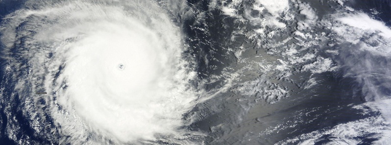
Featured image: Eunice on January 30, 2015. Image credit: NASA Terra/MODIS
Tropical Cyclone "Eunice" formed on January 28 over the open waters of South Indian Ocean and rapidly intensified. Eunice is a powerful storm, however, it is located far from any land.
According to JTWC warning issued 00:00 UTC today, Eunice had maximum sustained (1-minute) average wind speed of 259 km/h (161 mph) and wind gusts of 314 km/h (195 mph). On Saffir-Simpson Hurricane Wind Scale this would be a Category 5 hurricane, the strongest. Its maximum significant wave height at the time was 11.5 meters (38 feet).
At 03:00 UTC today, Eunice was located approximately 1126 km (699 miles) ENE of Port Louis, Mauritius and has tracked SSE at 14.8 km/h (9.2 mph) over the past six hours.

Eunice forecast track by JTWC on January 30, 2015
Animated enhanced infrared satellite imagery depicts deep symmetric central convection surrounding a well-defined 57 km (35 miles) eye.
JTWC expects Eunice to continue intensifying during the next 24 hours to a maximum intensity of 277.8 km/h (172.6 mph). It is expected to begin its extra-tropical transition within 5 days.

Eunice on January 30, 2015. Image credit: NASA Terra/MODIS
According to RSMC La Reunion Tropical Cyclone Warning issued 06:00 UTC today, Eunice had central pressure of 915 hPa, and a maximum average (10-minute) wind speed of 240 km/h (149 mph).
This makes Eunice a Very intense tropical cyclone on South-west Indian Ocean Tropical Cyclone intensity scale.
Meanwhile, what's left of once Moderate tropical storm "Diamondra" is tracking to the SE.
Between 00:00 and 06:00 UTC today, Diamondra has lost its purely tropical characteristics and became a post-tropical depression.

Eunice and Ex-Diamondra on January 30, 2015. Image credit: UW CIMSS
Diamondra is expected to complete its extra-tropical transition later this weekend.

Image credit: METEO France/RSMC La Reunion
Satellite animations
- Storm-Centered Infrared (Meteosat 7; CIMSS)
- Storm-Centered Enhanced Infrared (Meteosat 7; CIMSS)
- Storm-Centered Water Vapor (Meteosat 7; CIMSS)
- Storm-Centered Visible (Meteosat 7; CIMSS)
- Meteosat 7 Infrared (Meteosat 7; CIMSS)
- Meteosat 7 Infrared (Color Background) (Meteosat 7; CIMSS)
- Meteosat 7 Infrared (NHC Color Enhancement) (Meteosat 7; CIMSS)
- Meteosat 7 Water Vapor (Meteosat 7; CIMSS)
- Meteosat 7 Water Vapor (Color Background) (Meteosat 7; CIMSS)

Teo Blašković founded The Watchers in 2011 and edited it until 2026, covering seismic and volcanic activity, extreme weather, space weather and near-Earth objects. Articles on this page are his archive.
Published in the last 24 hours
- Strong El Niño reinforces above-normal winter precipitation outlook across southern and eastern U.S.
- Scientists directly observe how submarine landslides unfold in western Canada Epicenter
- Odisha evacuated 983,642 people before Phailin crossed near Gopalpur on 12 October 2013 with winds of 200-210 km/h gusting to 220, and 44 died, against 9,885 in the 1999 super cyclone. Cyclone Akvan crossed the same coast on 20 November 2026. Epicenter
- Lava fountains reached 1,900 feet (580 m) at Kīlauea Iki in 1959, the highest ever recorded at Kīlauea, as USGS forecasts episode 57 fountaining at Halemaʻumaʻu for November 22-26. Epicenter



