
B.C. earthquakes could be foreshocks leading to a large one, Canada
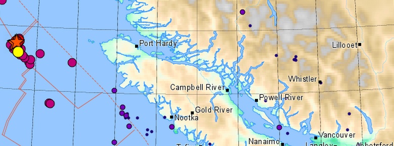
Image credit: Earthquake Canada
A swarm of earthquakes that started in December 2014 along the border of the Juan de Fuca and North American plates, northwest of Vancouver Island, British Columbia – Canada, continued into 2015 with two moderately strong earthquakes measuring M4.5 and 5.2 on the Richter scale.
According to John Clague, a Simon Fraser University professor, a larger earthquake off Vancouver Island’s shore could be around the corner.
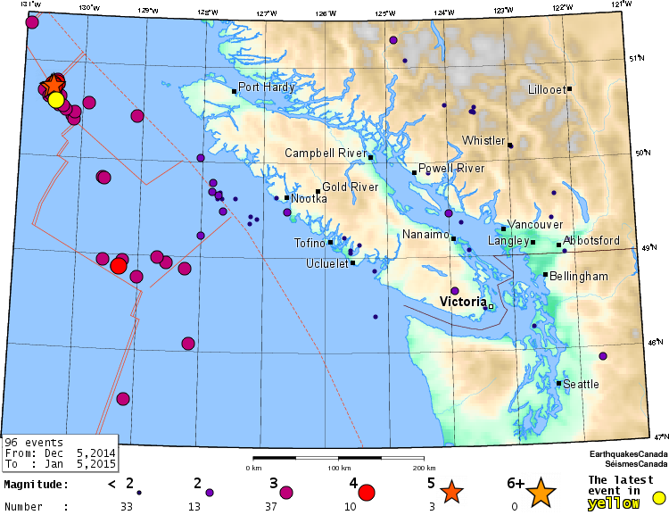
The swarm started on December 17, 2014 with M3.8 at a depth of 10 km, 195 km west of Port Hardy, according to data collected by Earthquake Canada.
By January 5, 2015 they registered a total of 39 moderate to strong earthquakes in the same region, with the strongest one being 10-km deep, M5.4 on January 2, 2015. See the map and a complete list of quakes below.
“It is an earthquake-prone territory, but this is a fairly large number of earthquakes to have in such a short period. It’s possible we won’t know until time passes that these could be foreshocks of a larger earthquake in the same area, something in the magnitude six or seven range,” Clague said.
Although the slew of tremors have been frequent, there’s no direct link for it to trigger the “big one” further south on the Juan de Fuca plate and the Cascadia Subduction Zone, he explained and added that while it is normal for a cluster of earthquakes to hit along the border of the Juan de Fuca and North American plates, it’s unlikely any damage will result from a seven-magnitude quake, as long as it remains offshore.

There is good evidence that the Juan de Fuca and North America plates are currently locked together, causing strain to build up in the earth's crust. It is this squeezing of the crust that causes the 300 or so small earthquakes that are located in southwestern British Columbia each year, and the less-frequent, once per decade, on average, damaging crustal earthquakes (e.g., a magnitude 7.3 earthquake on central Vancouver Island in 1946).
At some time in the future, these plates will snap loose, generating a huge offshore "subduction" earthquake – one similar to the 1964 M=9.2 Alaska earthquake, or the 1960 M=9.5 Chile earthquake. Current crustal deformation measurements in this area provide evidence for this model. Geological evidence also indicates that huge subduction earthquakes have struck this coast every 300 – 800 years. (Earthquakes Canada)
| Date | Time (UTC) | Depth | Mag | Region |
|---|---|---|---|---|
| 2015/01/04 | 01:49:55 | 10.0 | 4.5 | 214 km W of Pt. Hardy,BC |
| 2015/01/02 | 15:00:29 | 10.0 | 3.4 | 213 km W of Pt. Hardy,BC |
| 2015/01/02 | 14:56:55 | 10.0 | 3.4 | 217 km W of Pt. Hardy,BC |
| 2015/01/02 | 14:37:55 | 10.0 | 3.1 | 215 km W of Pt. Hardy,BC |
| 2015/01/02 | 10:15:33 | 10.0 | 5.4 | 217 km W of Pt. Hardy,BC |
| 2014/12/31 | 05:38:51 | 10.0 | 2.7 | 217 km W of Pt. Hardy,BC |
| 2014/12/31 | 04:35:31 | 10.0 | 2.8 | 218 km W of Pt. Hardy,BC |
| 2014/12/30 | 19:28:11 | 39.5 | 2.0 | 105 km SSW of Pt. Hardy,BC |
| 2014/12/26 | 01:13:22 | 10.0 | 2.5 | 118 km SSW of Pt. Hardy,BC |
| 2014/12/25 | 01:26:46 | 10.0 | 3.3 | 213 km W of Pt. Hardy,BC |
| 2014/12/24 | 13:07:39 | 10.0 | 3.9 | 215 km W of Pt. Hardy,BC |
| 2014/12/23 | 23:49:59 | 10.0 | 3.7 | 220 km W of Pt. Hardy,BC |
| 2014/12/23 | 23:42:15 | 10.0 | 3.7 | 222 km W of Pt. Hardy,BC |
| 2014/12/23 | 18:20:37 | 3.7 | 2.1 | 85 km SW of Pt. Hardy,BC |
| 2014/12/23 | 06:58:21 | 10.0 | 3.5 | 211 km W of Pt. Hardy,BC |
| 2014/12/23 | 03:00:03 | 10.0 | 3.6 | 215 km W of Pt. Hardy,BC |
| 2014/12/23 | 01:17:53 | 10.0 | 3.8 | 216 km W of Pt. Hardy,BC |
| 2014/12/23 | 01:16:21 | 10.0 | 3.4 | 221 km W of Pt. Hardy,BC |
| 2014/12/22 | 21:01:03 | 10.0 | 4.4 | 217 km W of Pt. Hardy,BC |
| 2014/12/22 | 06:51:37 | 10.0 | 4.5 | 219 km W of Pt. Hardy,BC |
| 2014/12/21 | 10:45:44 | 10.0 | 4.6 | 213 km W of Pt. Hardy,BC |
| 2014/12/21 | 10:19:45 | 10.0 | 4.3 | 217 km W of Pt. Hardy,BC |
| 2014/12/21 | 09:40:45 | 10.0 | 5.1 | 220 km W of Pt. Hardy,BC |
| 2014/12/21 | 07:35:48 | 10.0 | 4.0 | 216 km W of Pt. Hardy,BC |
| 2014/12/21 | 05:19:40 | 10.0 | 4.1 | 216 km W of Pt. Hardy,BC |
| 2014/12/21 | 03:59:50 | 10.0 | 3.8 | 215 km W of Pt. Hardy,BC |
| 2014/12/21 | 02:57:35 | 10.0 | 5.0 | 219 km W of Pt. Hardy,BC |
| 2014/12/20 | 22:54:28 | 10.0 | 4.6 | 216 km W of Pt. Hardy,BC |
| 2014/12/20 | 21:36:32 | 10.0 | 4.2 | 216 km W of Pt. Hardy,BC |
| 2014/12/20 | 17:45:23 | 10.0 | 3.7 | 213 km W of Pt. Hardy,BC |
| 2014/12/19 | 03:17:53 | 10.0 | 3.9 | 206 km W of Pt. Hardy,BC |
| 2014/12/19 | 02:25:33 | 10.0 | 3.6 | 211 km W of Pt. Hardy,BC |
| 2014/12/19 | 00:36:24 | 10.0 | 3.6 | 203 km W of Pt. Hardy,BC |
| 2014/12/18 | 22:31:59 | 10.0 | 3.7 | 228 km W of Pt. Hardy,BC |
| 2014/12/18 | 10:46:15 | 10.0 | 3.4 | 193 km W of Pt. Hardy,BC |
| 2014/12/18 | 08:34:01 | 10.0 | 3.5 | 209 km W of Pt. Hardy,BC |
| 2014/12/17 | 07:44:43 | 10.0 | 3.2 | 185 km WSW of Pt. Hardy,BC |
| 2014/12/17 | 06:33:24 | 10.0 | 3.3 | 186 km WSW of Pt. Hardy,BC |
| 2014/12/17 | 01:27:14 | 10.0 | 3.8 | 195 km W of Pt. Hardy,BC |
Data by Earthquake Canada. Last updated: 09:30 UTC on Monday, January 5, 2015.
- See the most recent 30-day earthquake list for southwestern British Columbia here.
- UNDERSTANDING WHY THE BIG EARTHQUAKE IS PREDICTED FOR VANCOUVER – By Kate Potter
I'm a dedicated researcher, journalist, and editor at The Watchers. With over 20 years of experience in the media industry, I specialize in hard science news, focusing on extreme weather, seismic and volcanic activity, space weather, and astronomy, including near-Earth objects and planetary defense strategies. You can reach me at teo /at/ watchers.news.
Commenting rules and guidelines
We value the thoughts and opinions of our readers and welcome healthy discussions on our website. In order to maintain a respectful and positive community, we ask that all commenters follow these rules.