
Multiple landfalling atmospheric rivers aim U.S. West Coast
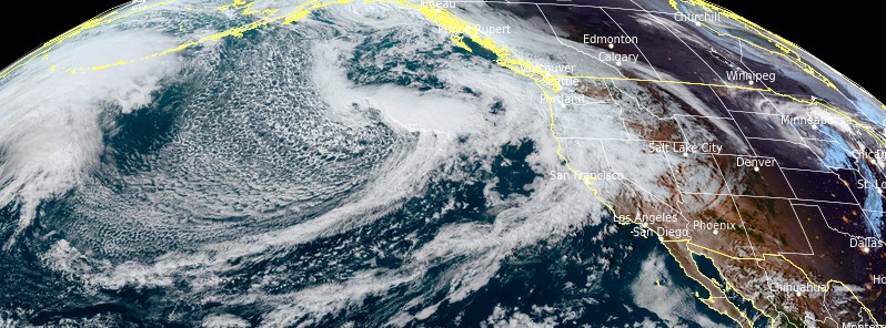
Image credit: NOAA/GOES-West, RAMMB/CIRA, TW
A series of landfalling atmospheric rivers (ARs) will impact the western United States, and British Columbia, this week into early next week, bringing excessive rainfall, strong winds, and mountain snow. This could lead to flash floods and dangerous debris flows in regions devastated by recent wildfires.
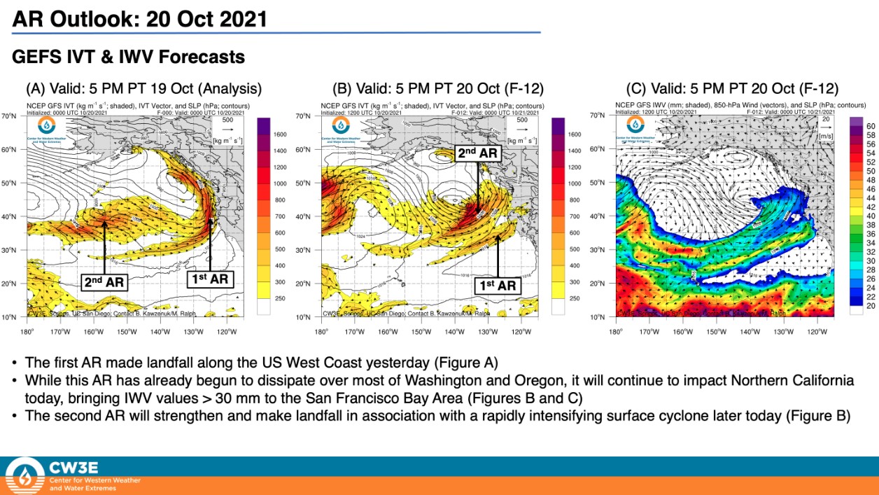
- AR 4/AR 5 conditions (based on the Ralph et al. 2019 AR Scale) are expected in coastal southern Oregon in association with the first and second ARs through Friday, October 22.1
- The strongest AR is forecasted to make landfall across Central and Northern California on Saturday, October 23 potentially bringing AR 4/AR 5 conditions to the San Francisco Bay Area.
- Inland penetration of this AR may bring AR 2/AR 3 conditions to portions of the interior western US.
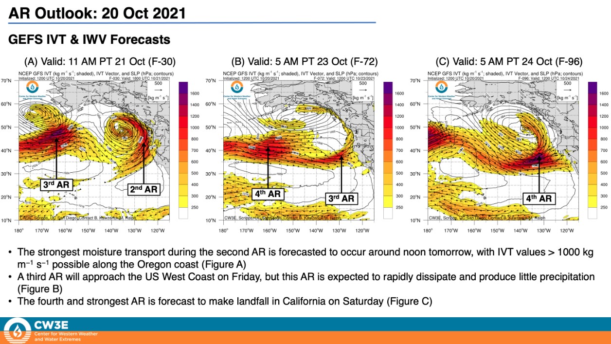
- Another landfalling AR is forecasted to impact the US West Coast on October 26 – 27.
- The first two ARs are forecasted to produce 50 to 100 mm (2 – 5 inches) of rainfall in portions of Northern California and southern Oregon.
- The fourth AR is forecasted to bring widespread precipitation to much of the western US, with the heaviest precipitation amounts in Northern California.
- Significant snowfall accumulations are also possible in the Sierra Nevada in association with the fourth AR.
- Portions of Northern California may receive more than 250 mm (10 inches) of total precipitation over the next 7 days.
A rapidly deepening cyclone in the northeast Pacific responsible for the development of an atmospheric river aimed at the West Coast and coastal British Columbia is set to produce unsettled weather that will arrive in the Pacific Northwest later today, NWS forecaster Mullinax noted.2
The bouts of rain are a sight for sore eyes in the drought-stricken areas of the Northwest with beneficial rainfall totals ranging between 50 – 100 mm (2 to 5 inches) in the higher elevations of Northern California and southwestern Oregon.
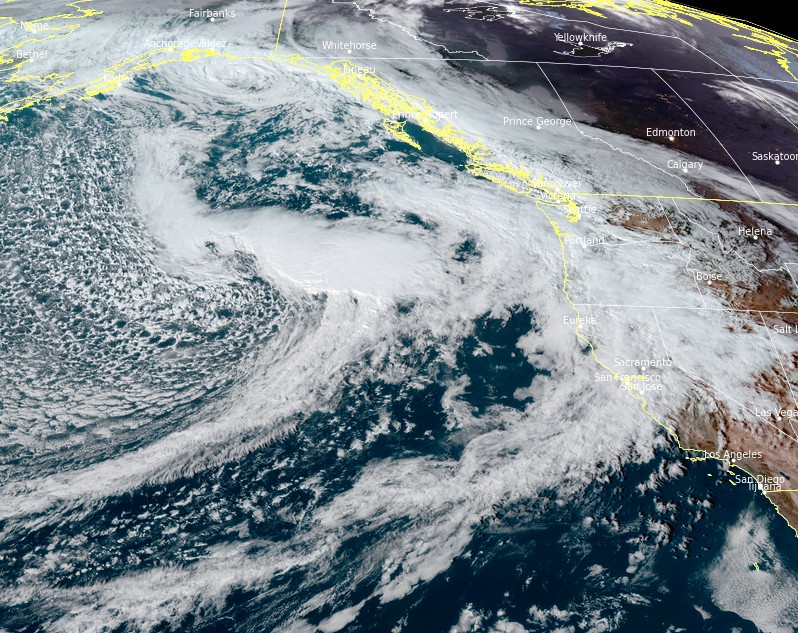
Image credit: NOAA/GOES-West, RAMMB/CIRA, TW. Acquired 23:20 UTC, October 21, 2021
However, locally heavy rainfall rates atop burn-scarred areas could lead to flash flooding, rapid runoff, and debris flows in these locations.
Slight Risks for Excessive Rainfall have been issued for a handful of areas in Northern California and far southwestern Oregon along with Flash Flood Watches in parts of the northern Sierra Nevada.
As the upper low associated with this Pacific storm moves ashore Thursday night, snow levels will drop throughout the night and into Friday as it also aids in pushing precipitation farther inland.
Despite the falling snow levels, snow totals will generally be light with the lone exceptions being the highest peaks of mountain ranges that include the northern Sierra Nevada, the Shastas, and the Cascades.
As the storm system pushes into the northern Rockies and gradually weakens, the next Pacific low pressure system is hot on its heels as it ushers in more unsettled weather into the Pacific Northwest on Saturday.
References:
1 CW3E AR Update: 20 October 2021 Outlook – CW3E
2 Short Range Forecast Discussion – NWS Weather Prediction Center College Park MD – 404 AM EDT Thu Oct 21 2021
I'm a dedicated researcher, journalist, and editor at The Watchers. With over 20 years of experience in the media industry, I specialize in hard science news, focusing on extreme weather, seismic and volcanic activity, space weather, and astronomy, including near-Earth objects and planetary defense strategies. You can reach me at teo /at/ watchers.news.
Commenting rules and guidelines
We value the thoughts and opinions of our readers and welcome healthy discussions on our website. In order to maintain a respectful and positive community, we ask that all commenters follow these rules.