
El Hierro volcano helps to improve algorithms used by satellites

Image credit: TW
Information provided by satellites on the amount of chlorophyll-A and the roughness of the sea following the eruption of the underwater volcano off the island of El Hierro (Spain) did not coincide with the actual data collected in situ by vessels carrying out oceanographic studies. The models have been corrected by researchers at the University of Las Palmas de Gran Canaria, who have for the first time processed very high resolution images of this kind of natural phenomenon captured from space.
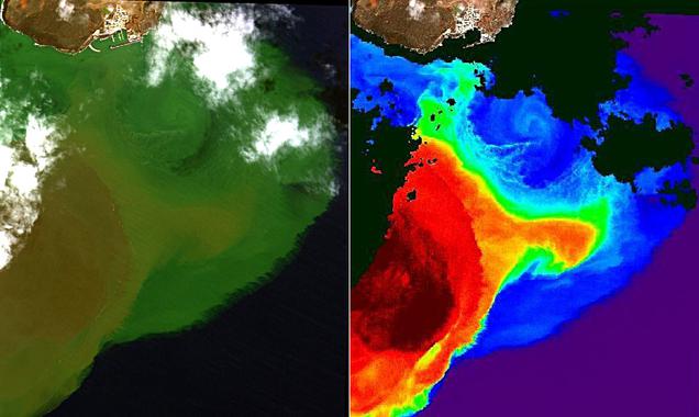
Image taken by the satellite WorldView-2 in October 2011. The bright green waters indicate high concentrations of volcanic material flowing from the brown zone, which is where the volcano is located. On the right, the ‘diffuse attenuation coefficient’ has been applied – this is an indicator of the water roughness level. The areas shaded in black are clouds. / Institute of Oceanography and Global Change (ULPGC).
The image of the Canary Islands which won the prize this year of NASA’s Earth Observatory was captured by one it its satellites, ‘Terra’, with the Moderate Resolution Imaging Spectro-radiometer (MODIS) instrument. This sensor also travels in the US space agency’s satellite ‘Aqua’ as well as alongside the Medium Resolution Imaging Spectrometer (MERIS) in the European Space Agency’s satellite Envisat, and they have helped to understand the evolution of the underwater volcano which emerged in 2011 beneath the waters surrounding the island El Hierro, in the Canary Islands.
However, the information supplied by MODIS and MERIS was incorrect with regard to certain marine parameters, according to measurements taken in situ by oceanographic research vessels of the Spanish Institute of Oceanography (IEO). This has now been confirmed by researchers of the University of Las Palmas de Gran Canaria (ULPGC) in a study published by the ‘International Journal of Applied Earth Observation and Geoinformation’.
“The algorithms used with the data from the NASA and ESA satellites made mistakes when determining the concentration of chlorophyll-A (a variable that indicates the biological productivity in marine ecosystems) as it showed concentrations that were greater than actual ones as measured by the research ships,” explained Francisco Eugenio, co-author of the study and researcher at the Institute of Oceanography and Global Change at the ULPGC, to SINC.
Members of this institute have developed new mathematical algorithms that correct the incongruities detected with chlorophyll-A as well as what is known as the ‘diffuse attenuation coefficient’ – an indicator of the sea turbulence in terms of dissolved material. This parameter had also been over-estimated when applied to the data from the satellites.
“In any case, the images processed from these remote sensors have proven to be a very powerful tool for monitoring effects associated with underwater volcanic activity, such as the change of colour of the water, the presence of floating matter and volcanic plumes,” Eugenio underlined.
The researcher also pointed out that, for the first time, very high resolution images have been obtained to follow this kind of geological phenomenon. These are the images obtained from the private satellite Worldview-2, which has a pan-chromatic resolution of 46 centimetres –in black and white– and 1.85 metres in 8 multi-spectral bands. New algorithms have also been used with these.
In the case of these images, as with the low-resolution images obtained from MODIS and MERIS, the researchers have been able to work out the chronology of the atmospheric, oceanographic and biological parameters in the ocean since the volcano erupted three years ago at a depth of 300 metres below the ocean surface.
This data has been supplemented with the samples retrieved from all round the island in the project called ‘Vulcano’, which was most recently conducted last March. For its part, the IEO’s underwater robot Lirupos 2000 has also captured the growth of the underwater volcano’s structure and the rapid rate at which the marine ecosystem is recolonizing the area.
“Currently, the volcano’s main crater is at the same depth as it was in October 2013, which is 88 metres below the ocean surface,” explains Eugenio, who goes on to confirm: “The waters around El Hierro are fine, and, with the exception of a small area within a 200-metre radius around the main crater, no physical or chemical anomalies have been detected at any point around the periphery of the island, from the ocean surface to depths of 1,200 metres.”
Source: SINC
References:
- F. Eugenio, J. Martin, J. Marcello, E. Fraile-Nuez. “Environmental monitoring of El Hierro Island submarine volcano, by combining low and high resolution satellite imagery”. International Journal of Applied Earth Observation and Geoinformation 29:53-66, 2014. – DOI: 10.1016/j.jag.2013.12.009
The Watchers team and our contributors bring the latest on extreme weather, earthquakes, volcanic eruptions, space weather, and all things science. We're all about making sense of the natural world and keeping you informed on what’s happening. Got a tip or a question? Hit us up using the form at newstips!
Commenting rules and guidelines
We value the thoughts and opinions of our readers and welcome healthy discussions on our website. In order to maintain a respectful and positive community, we ask that all commenters follow these rules.