
Shaking, cracks and dangerous rockfalls from strong M 5.4 quake near El Hierro, Canary Islands
Image credit: USGS
A strong earthquake registered as M 5.4 by USGS (mb 5.4 EMSC / mbLg 5.1 local IGN) struck 31 km northwest of La Frontera (El Hierro / Canary Islands) on December 27, 2013 at 17:46 UTC. IGN measured shallow depth of 11 km.
The epicenter was some 30 km NW from the relative location of most recent earthquake swarm and current inflation at El Hierro.
Shaking, cracks and dangerous rockfalls were reported throughout the island (see the videos below). La Frontera mayor has ordered and confirmed the closure of the road from Los Llanillos to Sabinosa.
This is the strongest earthquake the El Hierro witnessed since the start of the activity in July 2011, and the origin is most likely volcanic. Many aftershocks followed, all with depths of 11 – 15/20 km.
The scientific group of PEVOLCA has met this morning (Involcan, IGN, CSIC, universities and representatives of national, regional and island authorities in El Hierro) and concluded that the seismic series recorded on the island of El Hierro during the last days corresponds to a new process of magmatic intrusion.
Parts of El Hierro have swelled nearly 7 centimeters (3 inches) in the past week, with the growth centered between El Pinar and La Restinga.
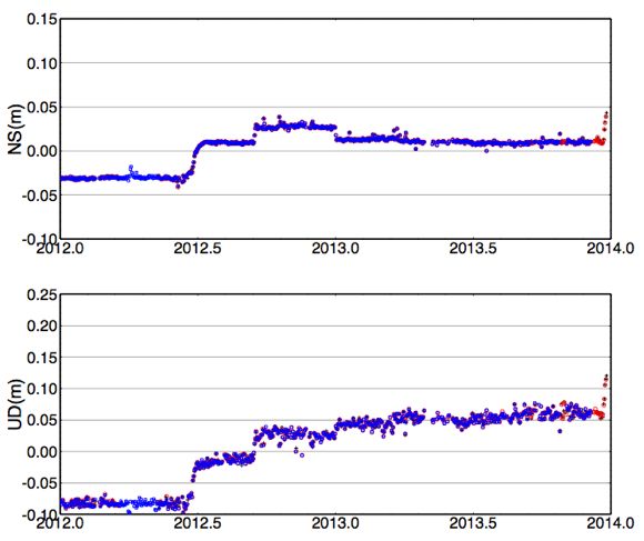
Involcan / Uni of Nagoya deformation at the El Pinar station earlier today (Ultra Rapid GPS data)
Couple of hours before the M 5.1 earthquake today volcanic eruption risk was set on "yellow" (activity is increasing at the volcano, but no eruption is imminent).
At 22:47 UTC, IGN recorded an M 3.6 earthquake at the same location but at depth of 20 km. See the complete earthquake list from IGN for December 27, 2013 below.
Video recorded on December 27, 2013. Courtesy Victor R. Rodriguez
Video recorded on December 27, 2013. Courtesy Volcanes de Canarias
List of earthquakes reported by IGN on December 27, 2013 (latest list is here):
| Evento | Fecha | Hora(GMT)* | Latitud | Longitud | Prof. (km) | Int. Máx. | Mag. | Tipo Mag. (**) | Localización |
| 1252115 | 27/12/2013 | 22:47:05 | 27.7447 | -18.3465 | 20 | 3.7 | mbLg | W FRONTERA.IHI | |
| 1252114 | 27/12/2013 | 22:17:30 | 27.7603 | -18.3206 | 12 | 2.6 | mbLg | W FRONTERA.IHI | |
| 1252112 | 27/12/2013 | 20:11:04 | 27.7821 | -18.2882 | 12 | 1.6 | mbLg | W FRONTERA.IHI | |
| 1252111 | 27/12/2013 | 19:33:12 | 27.7594 | -18.2875 | 12 | 2.0 | mbLg | W FRONTERA.IHI | |
| 1252110 | 27/12/2013 | 19:20:04 | 27.7215 | -18.2746 | 11 | 1.7 | mbLg | W FRONTERA.IHI | |
| 1252107 | 27/12/2013 | 18:36:47 | 27.7637 | -18.2964 | 12 | 1.8 | mbLg | W FRONTERA.IHI | |
| 1252106 | 27/12/2013 | 18:08:15 | 27.7447 | -18.2367 | 11 | 2.1 | mbLg | W FRONTERA.IHI | |
| 1252105 | 27/12/2013 | 18:02:18 | 27.7678 | -18.2713 | 11 | 2.0 | mbLg | W FRONTERA.IHI | |
| 1252102 | 27/12/2013 | 17:51:56 | 27.7729 | -18.2764 | 11 | 2.9 | mbLg | W FRONTERA.IHI | |
| 1252104 | 27/12/2013 | 17:51:02 | 27.7683 | -18.3038 | 15 | 2.7 | mbLg | W FRONTERA.IHI | |
| 1252096 | 27/12/2013 | 17:46:03 | 27.7825 | -18.2760 | 11 | V | 5.1 | mbLg | W FRONTERA.IHI |
| 1252103 | 27/12/2013 | 17:40:46 | 27.7797 | -18.3223 | 14 | 2.0 | mbLg | W FRONTERA.IHI | |
| 1252064 | 27/12/2013 | 12:53:50 | 27.6853 | -17.9688 | 16 | 1.9 | mbLg | SE EL PINAR.IHI | |
| 1252041 | 27/12/2013 | 09:37:33 | 27.6796 | -17.9623 | 17 | 1.9 | mbLg | SE EL PINAR.IHI | |
| 1252044 | 27/12/2013 | 01:36:20 | 27.7113 | -17.9626 | 14 | 1.7 | mbLg | E EL PINAR.IHI | |
| 1252042 | 27/12/2013 | 00:20:49 | 27.7064 | -17.9726 | 13 | 1.6 | mbLg | SE EL PINAR.IHI |
Earthquakes in the past 15 days at El Hierro:
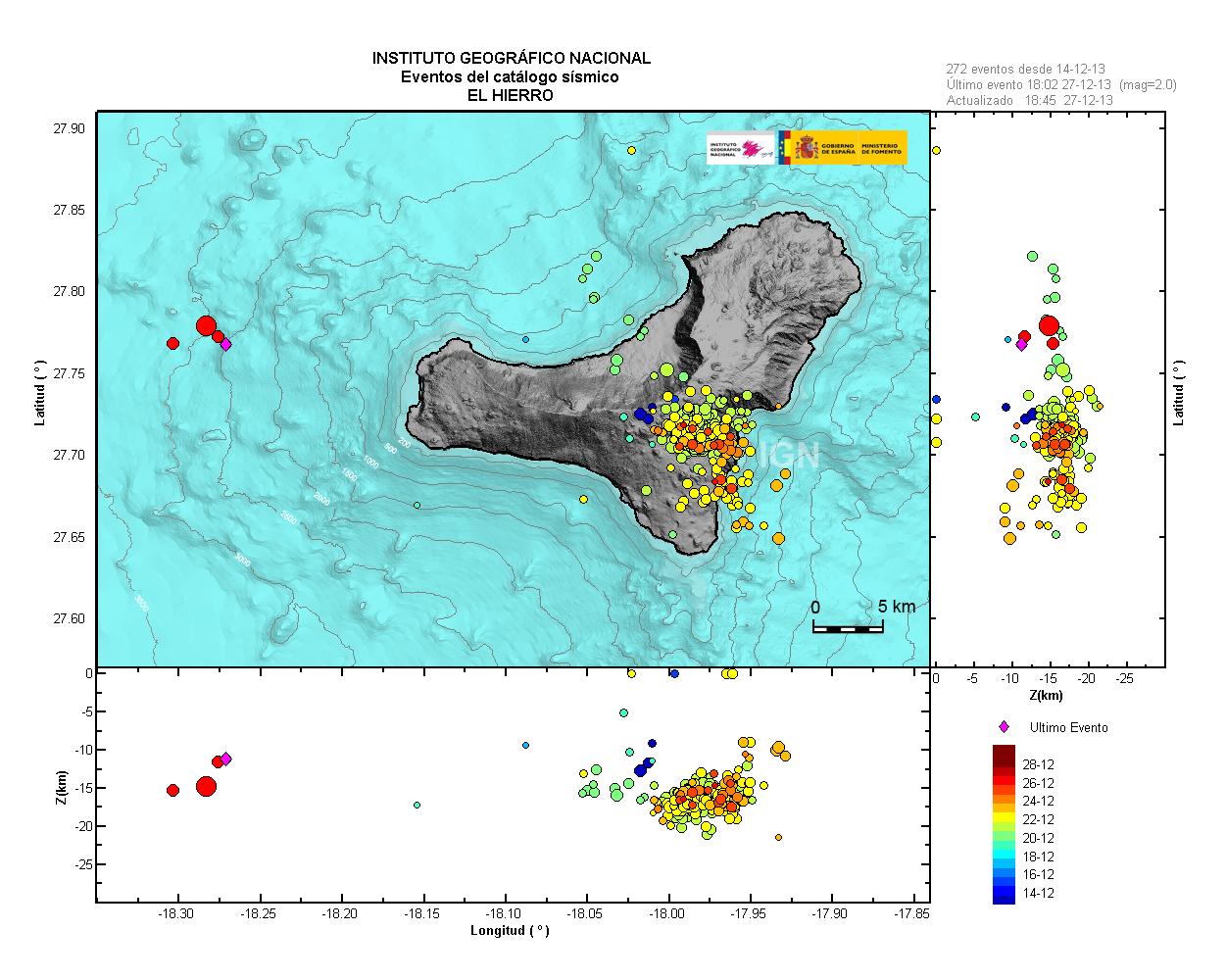
Image credit: National Geographic Institute (NGI)
Earthquakes since the start of activity (July 19, 2011):

Image credit: National Geographic Institute (NGI)
More information will be available in the morning (El Hierro's time zone is GMT/UTC).
El Hierro was the site of a spectacular underwater volcanic eruption in 2011:
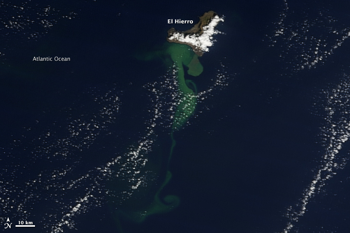
Image credit: NASA Terra / MODIS
Image above was captured on October 23, 2011. A milky green plume in the water stretches 25-30 kilometers at its widest and perhaps 100 kilometers long, from a large mass near the coast to thin tendrils as it spreads to the southwest.
The following image was acquired on November 2, 2011. The waters south of the island have been bubbling and fizzing with heat, sediment, bits of volcanic rock, and minerals for weeks, with the plume stretching tens of kilometers.
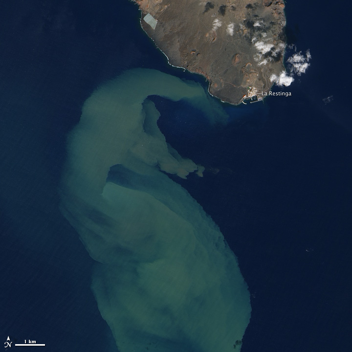
Image credit: NASA EO-1 / ALI
October 26, 2011 – Tremors were reported for the past several months from seismic stations on El Hierro, particularly in the northwest of the island. Then on October 12, 2011, the strength of the tremors significantly decreased while foaming, rock-strewn plumes appeared in the sea to the south of the island. The underwater plume of volcanic debris has persisted for nearly two weeks and has been mixed and dispersed by ocean surface currents. The eruption is occurring in water that is tens to a few hundred meters deep. (EO)
I'm a dedicated researcher, journalist, and editor at The Watchers. With over 20 years of experience in the media industry, I specialize in hard science news, focusing on extreme weather, seismic and volcanic activity, space weather, and astronomy, including near-Earth objects and planetary defense strategies. You can reach me at teo /at/ watchers.news.
booyaakaa……….
https://www.facebook.com/photo.php?v=239760539532765
East Coast of USA watch out if this volcano decides to blow.
Yes indeed.