
Impacts of El Niño and La Niña on the hurricane season
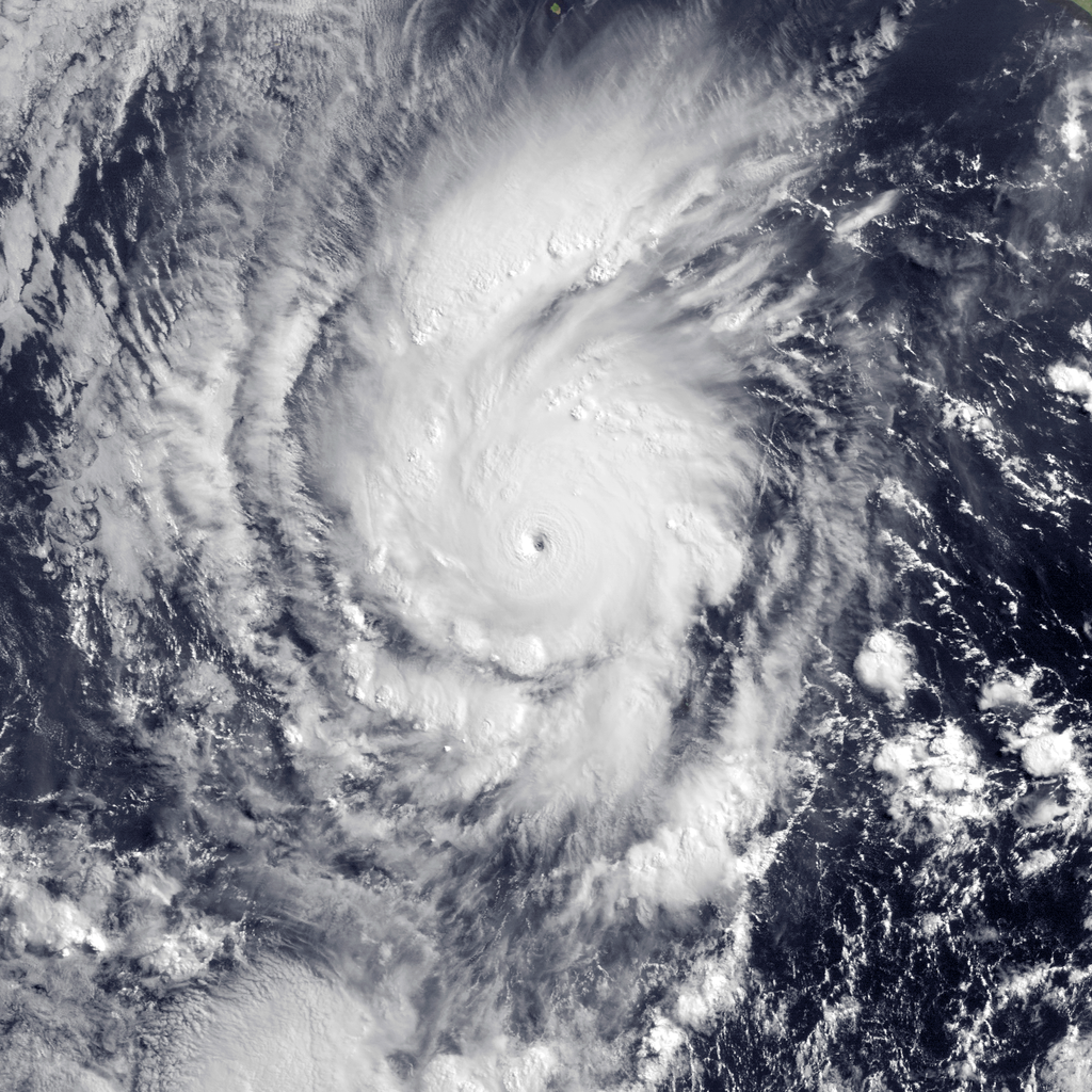
Featured image: Category 4 Hurricane Amanda seen by MODIS Aqua satellite at 14:45 UTC on May 24, 2014. (Credit: NOAA/LANCE Rapid Response/NRL Monterey Marine Meteorology Division)
Researchers have found that instances of Atlantic tropical storms and hurricanes are usually reduced during an El Niño year. 2014 hurricane season just started and there is a strong potential for El Niño to develop during the next few months.
El Niño is a phenomenon where ocean surface temperatures become warmer than normal in the equatorial Pacific. Warm El Niño events are characterized by more tropical storms and hurricanes in the eastern Pacific and a decrease in the Atlantic, Gulf of Mexico and the Caribbean Sea.
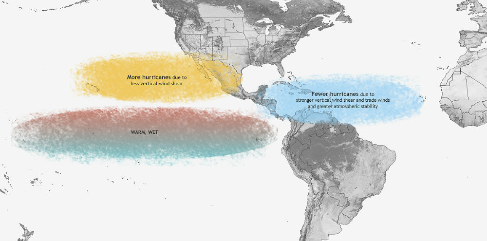
Typical influence of El Niño on Pacific and Atlantic seasonal hurricane activity. (Map by NOAA Climate.gov, based on originals by Gerry Bell.)
El Niño favors stronger hurricane activity in the central and eastern Pacific basins, and suppresses it in the Atlantic basin, while La Niña suppresses hurricane activity in the central and eastern Pacific basins, and enhances it in the Atlantic basin.
Hurricane activity in the Atlantic basin is affected by 'El Niño– Southern Oscillation' (ENSO) remotely through changes in the Atlantic atmospheric circulation, largely through the vertical wind shear, which refers to the change in wind speed and direction between roughly 1 500 – 10 600 m (5 000 -35 000 ft) above the ground.
During El Niño period, the wind patterns are aligned in such a way that the vertical wind shear is increased over the Caribbean and Atlantic, preventing tropical disturbances from developing into hurricanes. In addition to enhanced vertical wind shear, El Niño suppresses Atlantic hurricane activity by increasing the amount of sinking motion and increasing the atmospheric stability.
In the eastern Pacific, the wind patterns are altered in such a way to reduce the wind shear in the atmosphere, contributing to more storms.
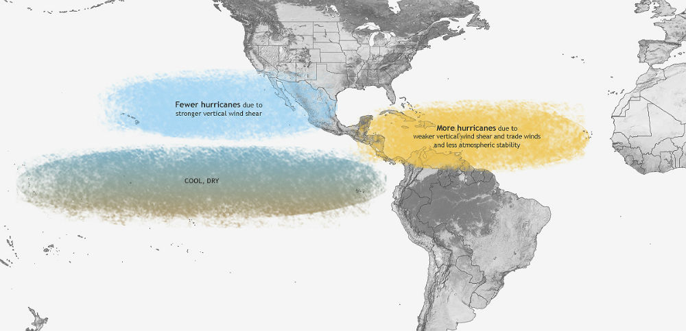
Typical influence of La Niña on Pacific and Atlantic seasonal hurricane activity. Map by NOAA Climate.gov, based on originals by Gerry Bell.
La Niña has opposite impacts across the Pacific and Atlantic basins. Over the central and eastern subtropical Pacific, the enhanced trough is associated with stronger upper-level winds and stronger vertical wind shear, which suppress hurricane activity. Over the Atlantic basin, the anomalous upper-level ridge is associated with weaker upper- and lower- level winds, both of which reduce the vertical wind shear and increased hurricane activity. La Niña also favors increased Atlantic hurricane activity by decreasing the amount of sinking motion and decreasing the atmospheric stability.
Other climate patterns that influence hurricanes
Besides southern oscillation, another climate factor that influence Atlantic hurricane activity is the Atlantic Multi-Decadal Oscillation (AMO). The warm phase of the AMO is associated with high-activity eras for Atlantic hurricanes, such as has been in place since 1995, while the cold phase of the AMO is associated with low-activity eras.
The warm phase of the AMO reflects warmer sea surface temperatures across the Atlantic hurricane Main Development Region (MDR). A key atmospheric feature of this pattern is a stronger West African monsoon, which produces a westward extension of the upper-level easterly winds, along with weaker easterly trade winds in the lower atmosphere.
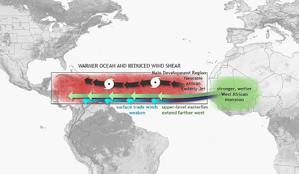
Climate patterns associated with the warm phase of the Atlantic Multi-decadal Oscillation (AMO). (Map by NOAA Climate.gov, based on originals by Gerry Bell)
This wind pattern is very conducive to increased Atlantic hurricane activity, partly because it results in weaker vertical wind shear. The weaker trade winds are also favoring hurricane development from tropical cloud systems moving westward from Africa. At the same time, these wind patterns are associated with a more northward push into the MDR of deep tropical moisture and unstable air, which favors stronger hurricanes.
During an Atlantic high-activity era, El Niño typically results in a near-normal season, and La Niña produces an above-normal season. During an Atlantic low-activity era, El Niño typically results in a below-normal season and La Niña results in a near-normal season.
The combination of a low-activity era and El Niño often produces a near-normal season for the central and eastern Pacific basins, while La Niña produces a below-normal season. For a Pacific high-activity era, El Niño often produces an above-normal season, while La Niña produces a near-normal season.
This year the expectation that El Niño will develop, combined with the multi-decadal climate signals results in a forecast for a near- or below-normal season in the Atlantic, and a near- or above-normal season in both the central and eastern Pacific.
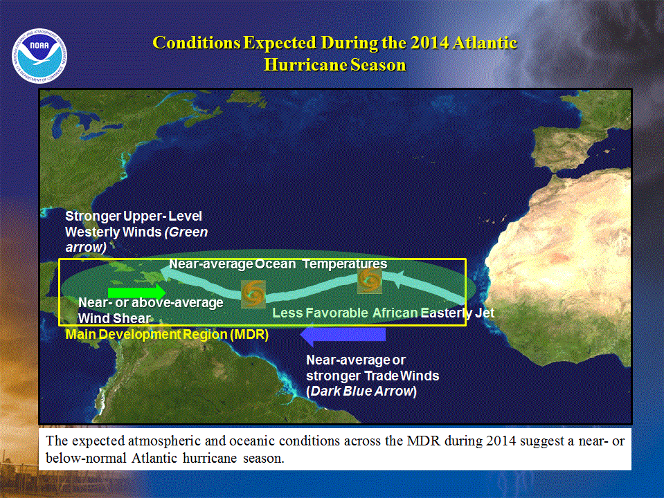
The predicted oceanic and atmospheric conditions across the MDR typify a near- or below-normal Atlantic hurricane season, and contrast with those seen throughout the current high activity era for Atlantic hurricanes that began in 1995. (Credit: NOAA/Climate.gov)
NOAA’s 2014 Atlantic Hurricane Season Outlook indicates that a near-normal or below-normal hurricane season is likely this year. The outlook calls for a 50% chance of a below-normal season, a 40% chance of a near-normal season, and only a 10% chance of an above-normal season. The expected conditions for 2014 reflect the likely development of El Niño during the summer or early fall, along with model predictions for near-average or below-average sea-surface temperatures (SSTs) in the Atlantic hurricane Main Development Region (MDR).
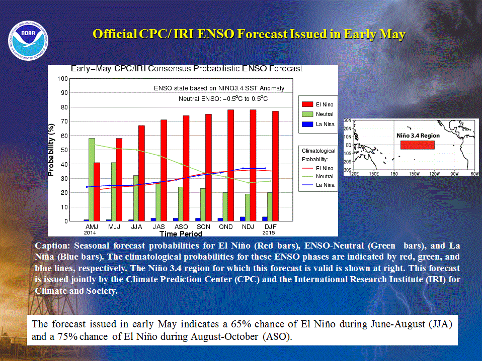
Official ENSO forecast issued in early May (Credit: NOAA/CPC/IRI)
However, during El Niño period, strong hurricanes in Atlantic are still possible. NOAA predicts a total of 8 to 13 named storms, with 3 to 6 developing into hurricanes and one to two intensifying into major hurricanes of Category 3 or higher. The seasonal averages are 12 named storms, 6 hurricanes and 3 major hurricanes. The first name to be used this season will be Arthur.
The Climate Prediction Center (CPC) predicts 14 to 20 named storms, 7 to 11 hurricanes and 3 to 6 major hurricanes. The Pacific season's first named storm, Amanda, developed on May 23, 2014. The next day, Amanda intensified into a category 4 hurricane.
Eastern Pacific hurricane season begins on May 15th and Atlantic hurricane season on June 1st. Both seasons officialy end on November 30th.
Commenting rules and guidelines
We value the thoughts and opinions of our readers and welcome healthy discussions on our website. In order to maintain a respectful and positive community, we ask that all commenters follow these rules.