
La Niña ENSO phase declared at the peak of hurricane season
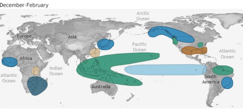
Image credit: NOAA
The National Oceanic and Atmospheric Administration (NOAA) has officially declared this year's La Niña phase on Thursday, September 10, 2020. The announcement comes at the peak of the hurricane season. This weather pattern occurs over the eastern Pacific, but has a worldwide impact, particularly for the Atlantic Basin.
According to the advisory issued by NOAA's Climate Prediction Center, there is a 75 percent chance that La Niña conditions will continue through the Northern Hemisphere Winter, from December 2020 to February 2021.
"La Niña can contribute to an increase in Atlantic hurricane activity by weakening the wind shear over the Caribbean Sea and tropical Atlantic Basin, which enables storms to develop and intensify," said NOAA's Climate Prediction Center deputy director, Mike Halpert.
"The potential for La Niña development was factored into our updated Atlantic hurricane season outlook issued in August."
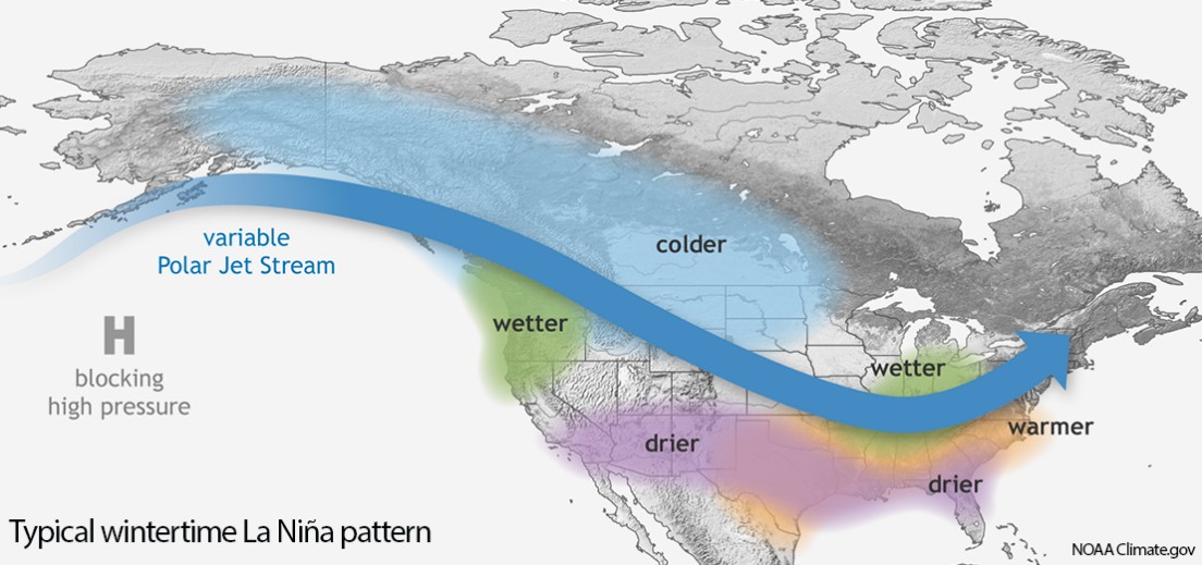
During the winter, La Niña usually brings above-average precipitation and colder-than-normal temperatures along the northern part of the U.S., along with below-average precipitation and above-average temperatures across the southern part.
"A region of concern this winter will be the Southwest, where a weak summer monsoon resulted in extreme drought," NOAA noted.
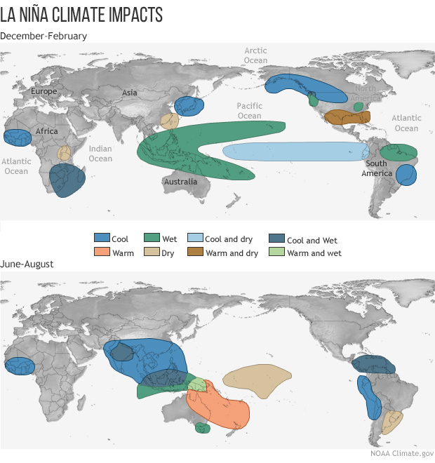
Image credit: NOAA
The previous La Niña emerged during the 2017/18 winter season, followed by an El Niño in 2018/19. When neither climate pattern is present, the El Nino Southern Oscillation (ENSO) is neutral and does not influence global climate patterns, like we saw during the winter of 2019/20.
Although both phases are just parts of a very complex climate system, by studying past events, we know they influence the global climate and disrupt normal weather patterns.
In Africa, La Niña generally results in wetter-than-normal conditions in Southern Africa from December to February, and drier-than-normal conditions over equatorial East Africa over the same period.
During La Niña years in Asia, the formation of tropical cyclones, along with the subtropical ridge position, shifts westward across the western Pacific Ocean, which increases the landfall threat in China. In March 2008, La Niña caused a drop in sea surface temperatures over Southeast Asia by 2 °C (3.6 °F). It also caused heavy rains over Malaysia, the Philippines, and Indonesia.
In North America, La Niña causes mostly the opposite effects of El Niño, above-average precipitation across the northern Midwest, the northern Rockies, Northern California, and the Pacific Northwest's southern and eastern regions. Meanwhile, precipitation in the southwestern and southeastern states, as well as Southern California, tends to be below average. This also allows for the development of many stronger-than-average hurricanes in the Atlantic and fewer in the Pacific.
In Canada, La Niña generally causes a cooler, snowier winter, such as the near-record-breaking amounts of snow recorded in La Niña winter of 2007/08 in Eastern Canada.
Coastal regions of Peru and Chile usually experience drought conditions, while Brazil is usually wetter than normal from December to February.
Heavy rains across the central Andes can result in catastrophic flooding on the Llanos de Mojos of Beni Department, Bolivia. Such flooding is documented from 1853, 1865, 1872, 1873, 1886, 1895, 1896, 1907, 1921, 1928, 1929 and 1931.
For Australia, La Niña typically increases rainfall across much of the continent and chances of widespread flooding. Of the 18 La Niña events since 1900 (including multi-year events), 12 have resulted in floods for some parts of Australia, with the east coast experiencing twice as many severe floods during La Niña years than El Niño years. Typically, some areas of northern Australia will experience flooding during La Niña because of the increase in tropical cyclone numbers. It brings cooler daytime temperatures south of the tropics and warmer overnight temperatures in the north.
The cooler than average daytime temperatures during La Niña years is often associated with a decreased frequency of extreme daily high temperatures across the continent.
In the warmer half of the year, southern coastal locations such as Adelaide and Melbourne experience fewer individual daily heat extremes during La Niña years but an increased frequency of prolonged warm spells. Of the 32 Victorian heatwaves between 1989 and 2009, 17 occurred during La Niña years while only 6 occurred during El Niño. During La Niña, there are typically more tropical cyclones in the Australia region, with twice as many making landfall than during El Niño years on average.
The date of the monsoon onset in tropical Australia is generally two weeks earlier during La Niña years than in El Niño years.
We can shift from El Nino to La Nina. this is based on the temperature of the ocean next to Peru. The temperature of the Gulf of Mexico is important this year. the extra heat in the Gulf of Mexico will make the whole 2020 hurricane season terrible.