
La Niña continues as NOAA forecasts transition to ENSO-neutral in February-April 2026
La Niña persisted across the equatorial Pacific in January 2026, with below-average sea surface temperatures and atmospheric patterns remaining consistent with the phase, according to the Climate Prediction Center Diagnostic Discussion issued on February 12, 2026. A transition to ENSO-neutral is expected during February–April 2026 with a 60% probability, while ENSO-neutral conditions are likely to continue through the Northern Hemisphere summer.
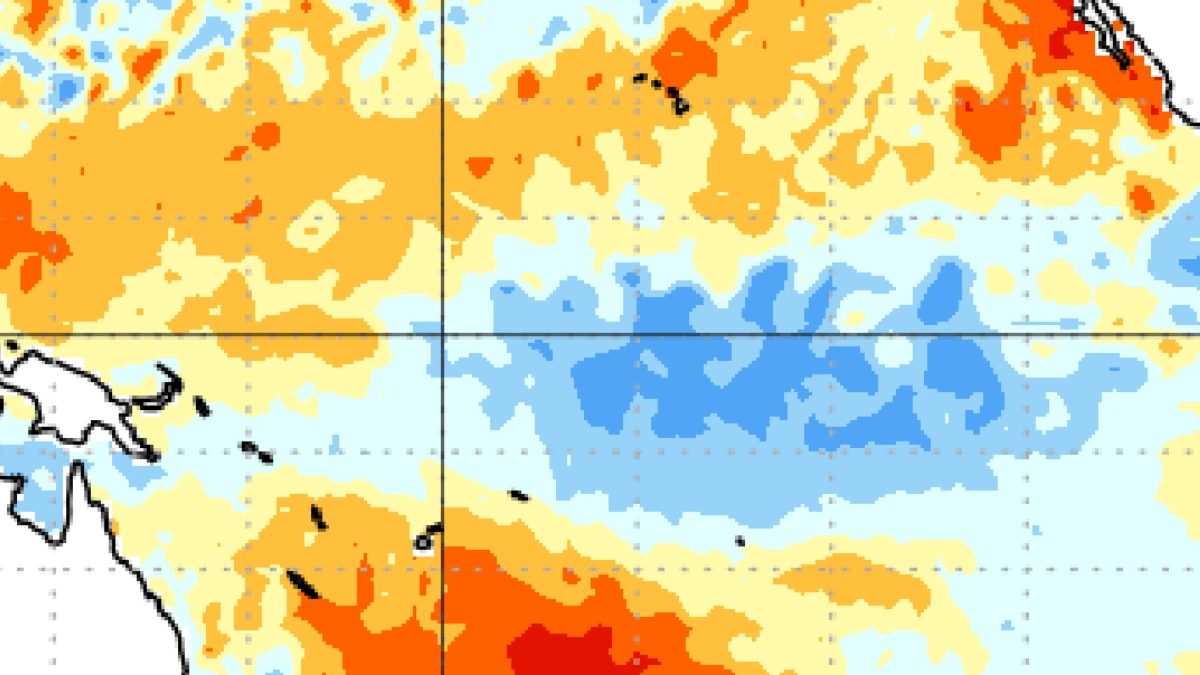
Image credit: NOAA/CPC
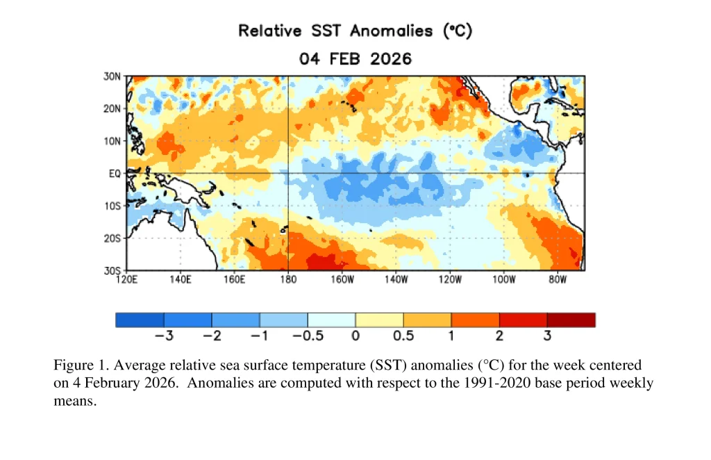
La Niña conditions continued across the equatorial Pacific during January 2026, with below-average sea surface temperatures (SSTs) observed in the east-central basin, according to the Climate Prediction Center’s (CPC) ENSO Diagnostic Discussion issued February 12.
The latest weekly Niño-3.4 index was −0.9°C (30.4°F). The Niño-4 index measured −0.4°C (31.3°F), while the Niño-1+2 index registered 0°C (32°F). These values reflect continued cooling in the central Pacific, consistent with La Niña thresholds.
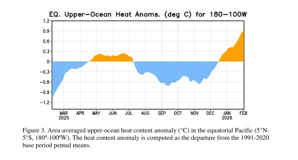
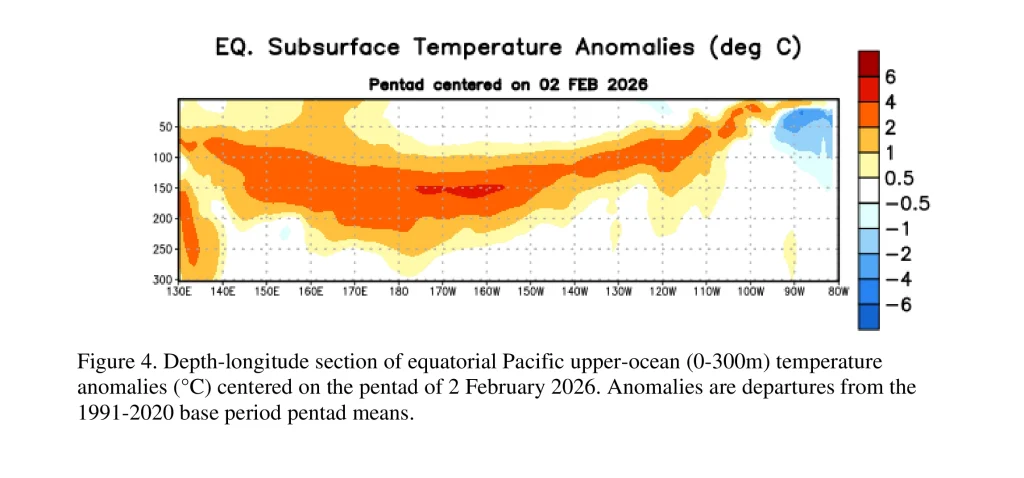
Subsurface ocean conditions shifted during January. The equatorial subsurface temperature index, averaged from 180° to 100°W, increased significantly as above-average temperatures strengthened and expanded beneath the surface across much of the Pacific basin. CPC reported that this subsurface warming signals weakening La Niña conditions.
Atmospheric indicators remained broadly consistent with La Niña, though anomalies weakened due to subseasonal variability.
Low-level westerly wind anomalies were present over the western equatorial Pacific, and upper-level westerly wind anomalies persisted across the east-central equatorial Pacific.
Suppressed convection was weak near the Date Line and across the equatorial Maritime Continent, with enhanced convection located off the equator. Both the traditional Southern Oscillation Index and the equatorial Southern Oscillation Index remained positive.
CPC reported that the coupled ocean–atmosphere system remained consistent with La Niña.
Model guidance favors a transition to ENSO-neutral during February–April 2026. The North American Multi-Model Ensemble (NMME), including the NCEP Climate Forecast System version 2 (CFSv2), supports this outlook. CPC assigns a 60% probability of ENSO-neutral development during this period.
ENSO-neutral conditions are likely to persist through the Northern Hemisphere summer, with a 56% probability during June–August 2026. Forecasters indicate a 50–60% chance of El Niño developing in late summer or later, though CPC notes that forecasts issued at this time of year typically have lower accuracy.
Global impacts of La Niña and El Niño
La Niña and El Niño represent the cold and warm phases of the El Niño–Southern Oscillation and are primary drivers of year-to-year climate variability. By shifting tropical convection and modifying the Walker circulation across the equatorial Pacific, both phases alter jet streams, storm tracks, and rainfall patterns worldwide.
During La Niña, strengthened trade winds and enhanced upwelling of cooler waters in the eastern Pacific favor wetter and cooler conditions across the Pacific Northwest and western Canada during boreal winter, while the southern United States often trends drier and warmer. Reduced vertical wind shear over the Atlantic basin can support increased tropical cyclone activity during the hurricane season.
La Niña is also associated with above-average rainfall in northern Brazil and parts of the Amazon Basin, increased precipitation in eastern Australia and portions of Southeast Asia, and enhanced flood risk in some regions of eastern Africa. Globally, La Niña years tend to be slightly cooler than El Niño years due to increased ocean heat uptake.
El Niño is characterized by anomalous warming of the central and eastern equatorial Pacific and a weakened Walker circulation. During boreal winter, this often enhances the subtropical jet stream across the southern United States, increasing the likelihood of wetter conditions from California to the Gulf Coast, while northern regions may experience warmer and drier conditions.
El Niño can suppress Atlantic hurricane activity due to increased vertical wind shear. It is commonly linked to heavy rainfall and flooding in coastal Peru and Ecuador, drier conditions in parts of northern South America, and elevated drought and wildfire risk in Australia and Indonesia.
Strong El Niño events are frequently associated with higher global mean surface temperatures, as reduced upwelling in the eastern Pacific limits ocean heat uptake.
The patterns described above are based on recurring links between ocean temperature anomalies in the tropical Pacific and shifts in global atmospheric circulation, relationships known in climate science as teleconnections. They reflect tendencies observed in the historical record rather than fixed outcomes.
The magnitude and geographic expression of impacts depend on event strength, duration, seasonal timing, and interactions with other climate modes and shorter-term atmospheric variability.
References:
1 EL NIÑO/SOUTHERN OSCILLATION (ENSO) DIAGNOSTIC DISCUSSION – Climate Prediction Center/NCEP/NWS – Issued February 12, 2026

I am an Assistant Editor and Severe Weather & Science Journalist at The Watchers, specializing in real-time severe weather coverage, geophysical event reporting, and research-driven scientific analysis. You can reach me at rishav(at)watchers(.)news.
Commenting rules and guidelines
We value the thoughts and opinions of our readers and welcome healthy discussions on our website. In order to maintain a respectful and positive community, we ask that all commenters follow these rules.