
Early wildfires season around Lake Baikal, Russia
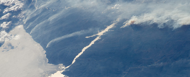
Image credit: Wildfires around Lake Baikal, Russia on April 22, 2014.
Temperatures around Russian Lake Baikal have skyrocketed in the past few weeks to 21 degrees Celsius (70 degrees F) prompting outbreaks of fire. Temperatures in this region are usually cooler until late July/early August when the bulk of the wildfires in this area normally erupt.
The Voice of Russia reports, "The Siberian Federal District reported 52 forest fires on an area of 53,644.1 hectares (132,557 acres) as of Thursday morning, the district department of the Federal Forestry Agency said. The wildfire rate is the highest in the Trans-Baikal territory – twelve fires burning on 48,150 (118,981 acres) hectares. There are 13 fires on 2,578.5 (6,370 acres) hectares in the Krasnoyarsk territory and four fires on 2,229 (5,507 acres) hectares in the Omsk region, the report runs."
This natural-color satellite image was collected by the Moderate Resolution Imaging Spectroradiometer (MODIS) aboard the Terra satellite on May 18, 2014.
Actively burning areas, detected by MODIS’s thermal bands, are outlined in red.

Image credit: NASA / Jeff Schmaltz, MODIS Rapid Response Team
Lake Baikal ("nature lake") is a rift lake in the south of the Russian region of Siberia, between the Irkutsk Oblast to the northwest and the Buryat Republic to the southeast, with greatest volume of fresh water in the world ~23,000 cubic km. It contains roughly 20% of the world's unfrozen surface fresh water. It is also among the clearest of all lakes, and thought to be the world's oldest lake at 25 million years.
It is usually still frozen over this time of year but it has already lost its ice coverage. Compare it to the image from April 22, 2014, (below) when ice was just starting to melt.
In this late afternoon shot, the crew aboard the International Space Station (ISS) looked back toward the setting Sun and captured the hook-shaped southern half of Lake Baikal in eastern Russia. Most of the lake is covered with dull gray ice. The brightest point in the image is the reflection of the Sun’s rays off a small zone of open water where the ice has begun to melt. Broken ice masses appear adjacent to the sunglint point. Sunlight also reflects off the water surface of the straight Angara River, the main outlet of the lake. (EO)

Image credit: NASA / ISS
Careless handling with fire and withered dry grass fires on the croplands reportedly were the main reasons for the fires. (NASA)

Teo Blašković founded The Watchers in 2011 and edited it until 2026, covering seismic and volcanic activity, extreme weather, space weather and near-Earth objects. Articles on this page are his archive.
Published in the last 24 hours
- High Risk of excessive rainfall covers Florida’s Space Coast as St. Johns River near Cocoa reaches 5.67 m
- Asteroid 2026 WJ to pass Earth at 1.7 lunar distances at 04:20 UTC on November 22, with 2026 WD following at 4.4 lunar distances on November 23
- Cyclone Akvan crossed the north Andhra Pradesh and south Odisha coasts close to Gopalpur on November 20 with 70-80 km/h winds gusting to 90, and has weakened into a deep depression
- A broad low over southeastern Florida and the northwestern Bahamas has a 30 percent chance of subtropical or tropical development within 48 hours and a 50 percent chance within 7 days, the National Hurricane Center says
