
Fire Weather Watches issued, SPC forecasts Critical conditions across parts of Nevada and Oregon
Critical fire weather conditions are forecast across a corridor from northwestern Nevada into southeastern Oregon on Monday afternoon, May 25, with sustained southwesterly winds of 32–40 km/h (20–25 mph), minimum RH of 10–15%, and recent fire activity showing fuels becoming more receptive to wildfire spread. NWS offices issued Fire Weather Watches for parts of northern Nevada, northeastern California, and the West Humboldt Basin for Monday afternoon and evening.

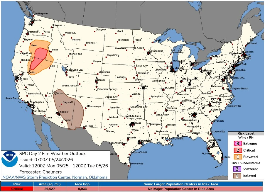
Critical Fire Weather valid 24 hours to 12:00 UTC on May 26, 2026. Credit: NWS/SPC
The Storm Prediction Center (SPC) placed about 68 960 km2 (26 627 mi2) under the Critical area, with 9 933 people inside the risk zone. The agency forecasts sustained southwesterly surface winds of 32–40 km/h (20–25 mph) across the main corridor from northwestern Nevada into southeastern Oregon, with adjacent Elevated fire weather conditions across parts of the Great Basin where sustained winds of 24–40 km/h (15–25 mph) overlap minimum RH values of 15–25%.
The fire weather setup is tied to a mid-level trough moving onshore over the Pacific Northwest and a cold front advancing eastward across the region with a deepening surface low. SPC said the strengthening surface pressure gradient ahead of the front will support the Critical corridor on Monday afternoon, while recent fire activity shows fuels in the region becoming more receptive to wildfire spread.
The National Weather Service (NWS) office in Elko issued a Fire Weather Watch for Fire Weather Zone 437, Humboldt County-Quinn, from 19:00 UTC on May 25 to 06:00 UTC on May 26. The watch calls for southwest winds of 32–48 km/h (20–30 mph) with gusts up to 72 km/h (45 mph) and relative humidity as low as 10%. The combination of gusty winds and low humidity will create critical fire weather conditions.
NWS Reno issued Fire Weather Watches for Surprise Valley, eastern Lassen County, northern Washoe County, and the West Humboldt Basin in Pershing County, including the Quartz Fire area. For Surprise Valley, eastern Lassen County, and northern Washoe County, the forecast includes west-southwest winds of 32–48 km/h (20–30 mph), gusts up to 72 km/h (45 mph), minimum RH of 10–15%, and a 3–7 hour critical window.
For the West Humboldt Basin, the watch calls for west-southwest winds of 32–48 km/h (20–30 mph), gusts up to 64 km/h (40 mph), minimum RH of 10–15%, and a 3–6 hour critical window.
NWS Boise forecasts elevated fire weather conditions in eastern Oregon on Monday as stronger south winds develop ahead of the Pacific cold front. Its Area Forecast Discussion calls for mostly dry conditions through Monday, temperatures about 6–8°C (10–15°F) above normal, isolated late-day and evening thunderstorms near the Idaho-Nevada border, gusty winds ahead of the front, and about 14°C (25°F) of cooling Tuesday.
For the Burns BLM zone in southeastern Oregon, NWS Boise forecasts Monday minimum RH of 11–17%, southwest valley and lower-slope winds of 26–35 km/h (16–22 mph), and afternoon gusts increasing to 55 km/h (34 mph). For Steens Mountain, the Monday forecast calls for minimum RH of 13–19%, southwest valley and lower-slope winds increasing to 24–34 km/h (15–21 mph), and gusts up to 55 km/h (34 mph) in the afternoon.
SPC maintains a 10% dry-thunderstorm probability across parts of northeastern Arizona and western New Mexico for Monday afternoon.
The National Interagency Fire Center (NIFC) Predictive Services described normal significant fire potential for most of the Great Basin in May, with brief increases possible for a burning period in standing dead carryover and dried brush on windy days in southern Idaho, northern Nevada, and northern Utah.
The May 23 NIFC Incident Management Situation Report had National Preparedness at Level 2, with 16 uncontained large fires nationwide, and 2 Great Basin active incidents covering 2 945 ha (7 279 acres).
References:
1 SPC Day 2 Fire Weather Outlook – NWS/SPC – May 24, 2026
I'm a dedicated researcher, journalist, and editor at The Watchers. With over 20 years of experience in the media industry, I specialize in hard science news, focusing on extreme weather, seismic and volcanic activity, space weather, and astronomy, including near-Earth objects and planetary defense strategies. You can reach me at teo /at/ watchers.news.
Commenting rules and guidelines
We value the thoughts and opinions of our readers and welcome healthy discussions on our website. In order to maintain a respectful and positive community, we ask that all commenters follow these rules.